Hwangmaesan Hiking Guide: Azalea Plateau and Summit
A practical guide to hiking Hwangmaesan — Korea's most accessible alpine plateau with one million pink royal azaleas in May and silver grass fields in October.

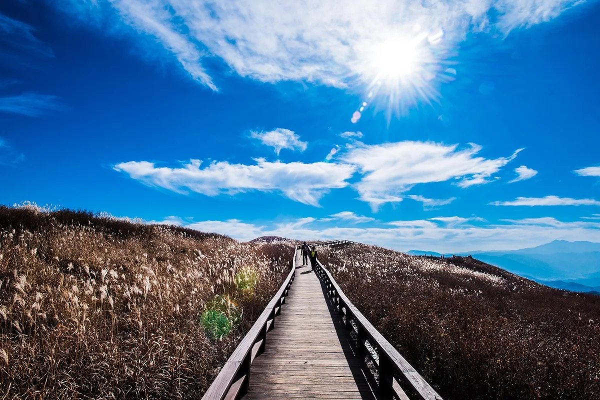
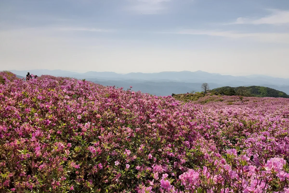
Hwangmaesan is the mountain that lets you skip most of the climb. Its highest point stands at 1,108 meters above sea level on the border of Hapcheon and Sancheong counties in South Gyeongsang Province, but the main trailhead parking sits at roughly 800 to 900 meters. That single fact — a paved road reaching nearly to the plateau — is what makes Hwangmaesan one of the most visited non-national-park mountains in Korea. In May, one million pink royal azaleas (철쭉) cover 30 hectares of the ridge. In October, a 60-hectare silver grass field takes over the same plateau. Both can be reached on foot in under an hour from the upper parking lot.
The mountain was designated a county park (군립공원) by Hapcheon County in 1983 — a tier below national park status, but with comparable infrastructure. It belongs to the Sobaek mountain range and is sometimes called "the Geumgangsan of Yeongnam" for the way exposed granite and diorite ridges rise above forested slopes. The bedrock is mostly diorite with minor gabbro and granite, and the signature landscape feature is the Hwangmaepyeongjeon (황매평전) — a high-elevation peneplain on the eastern slopes between 700 and 900 meters, which provides the gently rolling plateau surface that holds the azalea and silver grass fields.
The azalea season is the reason most international visitors come. The Hwangmaesan Royal Azalea Festival has run annually since 1997, typically the first two weeks of May, and draws more than 60,000 visitors over a ten-day window. The plants are wild mountain azaleas (Rhododendron yedoense var. poukhanense) — native Korean rhododendrons, not ornamental garden varieties — and they cover the plateau densely enough that photographs often show nothing but pink from foreground to horizon. The silver grass field at 60 hectares is roughly twice the size of the azalea field and peaks in mid-October with golden-to-silver wave patterns that bend with the wind.
Hwangmaesan also has a cinematic history. The 2003 Korean War film Taegukgi: The Brotherhood of War (태극기 휘날리며) was partly filmed on the mountain and in the adjacent Hapcheon Film Theme Park, and the area has since hosted around 300 Korean film and television productions. The main ridge and plateau have been visible in series ranging from Mr. Sunshine to a well-known BTS music video location at Byeolbicheon-eondeok (별빛언덕, "Star Hill"). Night sky photography is another draw: above 1,000 meters with minimal light pollution, Milky Way visibility is among the best in the southern half of the peninsula.
Quick Info
Quick summary for planning your Hwangmaesan hike at a glance.
- Location: Hapcheon-gun & Sancheong-gun, Gyeongsangnam-do (South Gyeongsang Province)
- Elevation: 1,108m
- Mountain Range: Sobaek
- Park Designation: Hapcheon County Park (1983)
- Signature Features: 30-hectare royal azalea field, 60-hectare silver grass plains, drive-up trailhead at ~900m
- Festivals: Royal Azalea Festival (early May), Silver Grass Festival (late October)
- Difficulty: Very Easy (plateau walk from parking) to Moderate (full summit and ridge traverse)
- Best Time to Visit: Early May (azalea peak), Mid-October (silver grass peak)
- Entrance Fee: FREE (county park)
- Parking: Free; ~300 spaces at main lot
- Travel Time from Seoul: ~4h by car; ~4.5h by express bus
- Travel Time from Busan: ~2h by car
Trail Overview
| Trail | Distance | Elevation Gain | Time | Difficulty | Best For |
|---|---|---|---|---|---|
| Course 1: Sincheon Village to Parking Lot 1 | 2.75km one-way | +~250m | ~1h | Easy | Shortest forest approach |
| Course 2: Jangbak Village to Neobaegi Rest | 4.09km | +~400m | ~2h | Easy–Moderate | Noru Rock landmark route |
| Course 3: Igyo Village via Buamsan | 9.20km | +~700m | 3–4h | Moderate | Full traverse with adjacent peak |
| Course 4: Sangbeop Village via Byeongbawi | 6.35km | +~600m | 2–3h | Moderate–Hard | Rock formation viewpoints |
| Plateau Walk from Upper Parking | 2–3km loop | +~150m | 1–2h | Very Easy | Azalea/silver grass sightseeing |
| Accessible Barrier-Free Trail | — | Minimal | Flexible | Wheelchair Accessible | All visitors, elderly, disabled |
Why Hwangmaesan Is Korea's Most Accessible Alpine Plateau
Most 1,100-meter Korean mountains require a serious climb. Jirisan's Cheonwangbong needs at least six hours. Seoraksan's Daecheongbong is a two-day commitment from most trailheads. Hwangmaesan's plateau — the part with the azaleas and silver grass — is 15 minutes of walking from a paved parking lot. That is the entire pitch.
The reason is the Hwangmaepyeongjeon, a geological peneplain formed over millions of years of differential erosion on the mountain's eastern flank. Harder diorite ridges remained standing while softer surrounding rock weathered down, leaving a gently rolling high-elevation surface between 700 and 900 meters. A county access road runs up this eastern side to Parking Lot 1 at approximately 900 meters elevation. From there, the plateau itself is a near-flat walk.
This accessibility shapes the visitor profile in ways no national park shares. Hwangmaesan draws wedding photographers, elderly bus tour groups, families with strollers, and amateur astronomers alongside serious hikers. The Hapcheon County Park authority has built a dedicated barrier-free trail section (무장애길) with wheelchair-graded surfaces specifically to serve visitors who cannot manage stairs or steep slopes. For a Korean alpine environment, this level of accessibility is unusual.
The azalea field itself has an interesting ecological history. The current plateau vegetation was not always this way. Starting in 1984, a government livestock promotion program established pastures on the Hwangmaepyeongjeon, and grazing cattle and sheep selectively ate grasses and palatable plants while avoiding the mildly toxic azalea leaves. Over decades, that selective grazing pressure produced the current near-monoculture of royal azalea and silver grass. The 30-hectare azalea field — roughly 60 football pitches — is the largest wild royal azalea colony in Korea.
For comparison, Sobaeksan and Jirisan also have significant royal azalea populations, but those are ridge-line distributions at higher altitude requiring multi-hour hikes to reach. Hwangmaesan puts roughly the same density of azaleas 20 minutes from a parking lot. That tradeoff — county park status for radical accessibility — is the core of Hwangmaesan's character.
Difficulty and Time Required
Hwangmaesan is exceptional in Korea for the range of fitness levels it serves on a single mountain. A family with young children can drive to the upper parking lot, walk 15 minutes onto the plateau, see the azaleas or silver grass, eat at a vendor stall, and drive back down in under two hours. A serious hiker can start from one of the valley villages and traverse the full ridge, summit included, in four to five hours.
The plateau walk from the upper parking area is the dominant route by visitor volume. From Parking Lot 1 (around 900 meters), a well-graded path leads onto the Hwangmaepyeongjeon and through the azalea or silver grass fields, with multiple observation decks and loop options. Roughly 2 to 3 kilometers total, 1 to 2 hours, minimal elevation. The summit — 1,108 meters — adds another 30 to 45 minutes of steeper walking above the plateau.
Course 1 (Sincheon Village to Parking Lot 1) is the shortest valley-based route at 2.75 kilometers and 1 hour. It climbs through forest before reaching the plateau approach. Course 2 (Jangbak Village via Noru Rock) is 4.09 kilometers and 2 hours with a scenic rock formation en route. Course 3 (Igyo Village via Buamsan) is the full traverse — 9.20 kilometers over 3 to 4 hours, linking the neighboring Buamsan peak with Hwangmaesan proper. Course 4 (Sangbeop Village via Byeongbawi) is the most rugged day-hike option at 6.35 kilometers over 2 to 3 hours with exposed rock formation views.
The summit section itself is steeper than the plateau but short. Expect some rock steps and a final exposed ridge. In good weather this is straightforward. In wind, rain, or ice, careful footing matters. There are no technical sections requiring scrambling gear.
Seasonally, the difficulty varies more than the distance. Early May is crowded — 10,000 daily visitors on festival weekends, parking filled by 7:00 AM. Mid-October silver grass peak brings similar crowds. Summer is hot and humid below 800 meters with afternoon thunderstorm risk. Winter is the quietest season but brings ice risk on exposed ridge sections, particularly north-facing slopes after snow.
Trail Options
Plateau Walk from Upper Parking — The 15-Minute Azalea Access
From Parking Lot 1 at approximately 900 meters, a wide paved-then-gravel path leads onto the plateau. In 15 to 20 minutes of flat walking you reach the central Hwangmaepyeongjeon — the actual azalea or silver grass field depending on season. Multiple loop options range from 2 to 3 kilometers total, with observation decks, the Byeolbicheon-eondeok (Star Hill) photo point, and the fire watch tower viewpoint all within easy reach.
The barrier-free trail (무장애길) branches off this main path with wheelchair-graded surfaces and graduated ramps. This section is maintained specifically for elderly visitors, wheelchair users, strollers, and anyone unable to manage stairs or rock steps.
Best for: All visitors, families with young children, elderly travelers, wheelchair users, sightseeing-first visits, azalea or silver grass photography without a mountain climb.
Course 1: Sincheon Village to Parking Lot 1 — The Shortest Forest Approach
From Sincheon (also called Mannam) village at the base, this is the shortest of the valley-based approaches — 2.75 kilometers one-way, approximately 1 hour of walking, 250 meters of cumulative elevation gain. The trail climbs through mixed pine and deciduous forest to join the plateau near the upper parking lot. Rated "easy" by Hapcheon County Park, suitable for hikers with moderate fitness who want a real uphill approach rather than driving to the top.
Best for: Day hikers skipping the upper parking crowds, shoulder-season visits, hikers who prefer a forest approach to the plateau, photographers wanting less-peopled starting conditions.
Course 2: Jangbak Village to Neobaegi Rest Area — Via Noru Rock
From Jangbak village, 4.09 kilometers to the Neobaegi rest area, approximately 2 hours at moderate pace. The route passes Noru Rock (노루바위), a signature granite formation partway up. Moderate elevation gain of around 400 meters. Rated "easy" by park classification but longer than Course 1, so budget extra time if linking to summit or plateau after arrival.
Best for: Hikers who want a named rock landmark mid-route, groups splitting pace across mixed fitness levels, photographers seeking Noru Rock composition.
Course 3: Igyo Village via Buamsan — The Full Traverse
From Igyo village, a 9.20-kilometer traverse over 3 to 4 hours, climbing neighboring Buamsan and continuing to Hwangmaesan's main plateau and summit. Approximately 700 meters of total gain. This is the longest of the standard courses and the most serious mountain day. Rated "moderate" by the park.
The route passes multiple summits, ridge sections with wide southern and western views, and eventually descends to the main plateau via the azalea/silver grass fields. Transport logistics require a pickup at the upper parking or at Sincheon village if you are not returning to Igyo.
Best for: Experienced day hikers, full-mountain traverses, peak-bagging combinations, photography across varied terrain.
Course 4: Sangbeop Village via Byeongbawi — The Rugged Alternative
From Sangbeop village, 6.35 kilometers over 2 to 3 hours, passing Byeongbawi (병바위, "Bottle Rock") and Tanggeonbawi rock formations. Rated "moderate to hard" by the park. Steeper terrain than Courses 1 and 2, with notable exposed rock sections and dramatic viewpoints over neighboring valleys.
Best for: Hikers who want the most rugged of the day routes, rock formation photography, alternative-angle summit approaches.
Best for Most Travelers
If you have two hours on a May or October weekend: drive to Parking Lot 1 and walk the plateau. Azaleas in May, silver grass in October, with minimal effort and maximum visual payoff.
If you have a half day: Course 1 uphill from Sincheon village plus the plateau loop. About 2.5 to 3 hours total, with a real forest approach earning the ridge views.
If you want a full mountain day: Course 3 from Igyo via Buamsan. Longer traverse, full summit experience, longer views.
If you are photographing the azaleas: arrive at Parking Lot 1 before 6:30 AM on a weekday during the May 1–15 peak. Golden hour light across the plateau without festival crowds.
If you are photographing silver grass: plan for the 4:00 to 6:30 PM window in mid-October for the golden-to-silver-to-bronze light transition and sunset over the plateau.
If you are with elderly travelers or have mobility limitations: the barrier-free trail section from the upper parking is genuinely accessible and delivers the core plateau experience.
Who Should Do This Hike
Hwangmaesan is one of the most inclusive mountains in Korea. Drive-up access to 900 meters, a barrier-free graded trail segment, and a short flat plateau walk mean that nearly any visitor can see the headline landscape. This makes it one of the rare Korean alpine environments that works for wheelchair users, young children, elderly travelers, and visitors with mobility limitations.
For photographers, Hwangmaesan rewards careful seasonal and time-of-day planning. The 30-hectare royal azalea field in early May is the single most dense and accessible wild azalea photography location in Korea — roughly one million plants across a continuous plateau, backed by views toward Hapcheon Reservoir. The 60-hectare silver grass field in October is one of Korea's premier autumn landscape sites, with wind-driven "silver wave" effects under low-angle sunset light. Cloud-sea conditions on clear dawns between May and October, when valley mist rises against overnight temperature inversions, give a third photographic window that compares well with Jirisan or Deogyusan.
Astronomy enthusiasts will appreciate the elevation-plus-darkness combination. Above 1,000 meters with minimal local light pollution, the Milky Way is visible on clear nights between April and October. Best viewing is typically 9:00 PM to midnight on new-moon nights, from the plateau observation decks.
Cinema and pop culture fans will find tangible filming-location draws. Taegukgi: The Brotherhood of War (2003) used the plateau for battle scenes. BTS filmed at Byeolbicheon-eondeok ("Star Hill"). The adjacent Hapcheon Film Theme Park has hosted around 300 productions including Mr. Sunshine and A Taxi Driver.
Serious multi-day hikers may find Hwangmaesan short. The full Buamsan–Hwangmaesan traverse caps at around 9 kilometers and 4 hours, without the technical or sustained elevation of Jirisan, Seoraksan, or Sobaeksan. Combine with nearby Hapcheon or Sancheong valley routes for a fuller day.
Tips Before You Go
- Festival crowds: Azalea Festival weekends (early May) and Silver Grass Festival weekends (late October) fill Parking Lot 1 by 6:30 to 7:00 AM. Arrive before 6:30 AM or visit on a weekday to avoid traffic backups on the access road.
- Weekday visits are substantially less crowded year-round. Even during peak azalea week, Tuesday through Thursday typically see fewer than half the weekend volume.
- The access road to Parking Lot 1 can briefly close during heavy rain, ice, or post-snow conditions. Check Hapcheon County Park's notices before the drive.
- Upper parking area facilities: free parking, restrooms, a seasonal convenience shop, weekend food vendor stalls, and picnic zones. No fuel. Fill up in Hapcheon town before the drive up.
- No entrance fee. Hwangmaesan is a county park, not a national park, and entry is free.
- Trail discipline during festival seasons: stay on marked paths. Both azaleas and silver grass are fragile and off-trail trampling during peak season can damage bloom areas for the following year. Trail rangers enforce this during festival periods.
- Insect risk: wasps and hornets can be common on the plateau in September and October. Carry an antihistamine if you are allergy-prone.
- Weather: summer afternoon thunderstorms develop between 2:00 and 4:00 PM, especially June and July. Start early and descend before peak heat and storm risk.
- Winter ice: exposed north-facing ridge sections can ice over from December through February. Microspikes or traction devices recommended for any ridge walk after snow.
- Night sky visits: bring a headlamp (red-filter preferred for astronomy), warm layers year-round (plateau temperatures drop 5 to 10°C after sunset), and be prepared for thin lighting at the parking lot.
- Nearest hospital: Hapcheon Medical Center (합천의료원). Emergency dispatch: 119.
- Local specialty: Hapcheon is known for dwaeji-gukbap (pork rice soup) and Sancheong for mountain-herb-based cuisine (산채정식).
How to Get There
By car (recommended): Seoul to Hwangmaesan via Gyeongbu Expressway and Daejeon-Tongyeong Expressway is approximately 4 hours. Busan to Hwangmaesan via Namhae Expressway is approximately 2 hours. Daegu to Hwangmaesan is approximately 1 hour 30 minutes. Use Hapcheon IC as the primary exit. GPS will route to Hwangmaesan County Park (황매산군립공원) — Parking Lot 1 is the main azalea and silver grass access.
By express bus: Seoul Express Bus Terminal to Hapcheon, approximately 3.5 to 4 hours. Busan Nopo Terminal to Hapcheon, approximately 1.5 hours. From Hapcheon Bus Terminal, taxi to Parking Lot 1 is approximately 15 to 20 minutes and around ₩15,000.
From Jinju: Local bus to Hapcheon town (45 minutes) plus taxi (15 minutes) to the upper parking lot. Total approximately 1 hour 30 minutes.
From Gimhae Airport (Busan): Approximately 2 hours by car, or taxi-plus-bus transfer via Hapcheon. Rental car is the most efficient option for international visitors.
Parking: Parking Lot 1 (main) holds approximately 300 vehicles and is free. Parking Lot 2 (at Sincheon village) serves Course 1 hikers. Dedicated barrier-free parking spaces are available at Parking Lot 1. During festival peaks, overflow parking is directed by traffic stewards.
Use Naver Maps or Kakao Map for real-time navigation.
Final Thoughts
Hwangmaesan is the mountain to visit when you want maximum visual impact for minimum physical effort. A paved road delivers you to 900 meters. A 15-minute flat walk puts you in the middle of either one million wild royal azaleas (May) or 60 hectares of silver grass (October). There is a barrier-free trail section so the core experience works for nearly any visitor, and there are real hikes up to the 1,108-meter summit for anyone who wants to earn the view the traditional way.
Pair the mountain with the Hapcheon Film Theme Park (15 minutes by road) if cinema locations interest you, or with nearby Haeinsa Temple on Gayasan (45 minutes) for a mountain-and-temple day. Early May and mid-October are the headline seasons. Weekdays and early starts avoid the festival crowds. For everything else, Hwangmaesan rewards visitors across virtually every fitness level.
For the best hikes reachable directly from Seoul by subway, see the full Seoul hiking guide.
Related Guides
Explore more hiking in Korea:
- Best hikes in Seoul — full overview of Seoul's mountains by subway
- Jirisan Hiking Guide — mainland Korea's highest summit and ridge traverse
- Seoraksan Hiking Guide — Korea's most famous hiking destination
- Hallasan Hiking Guide — Jeju Island's volcanic UNESCO triple-crown summit
- Naejangsan Hiking Guide — Korea's premier autumn foliage destination
- Wolchulsan Hiking Guide — Cloud Bridge and dramatic granite
- Taebaeksan Hiking Guide — sacred mountain, winter snow flowers, ancient yew grove
- Sobaeksan Hiking Guide — royal azalea ridge and UNESCO heritage academies
- Juwangsan Hiking Guide — UNESCO Geopark volcanic gorge and willow reflections
- Byeonsanbando Hiking Guide — Korea's only peninsula national park
FAQ
Is Hwangmaesan a national park? No. Hwangmaesan is a county park (군립공원), designated by Hapcheon County in 1983. It is administered at the county level rather than by the Korea National Park Service, but it offers comparable visitor facilities including parking, trails, restrooms, and a barrier-free accessible trail section. There is no entrance fee.
When is the best time to visit Hwangmaesan? Early May for the royal azalea peak (typically May 1 to May 15) and mid-October for the silver grass peak (typically October 10 to November 10). These are the two signature seasonal draws and the reason the mountain receives most of its annual visitors.
Can I drive up Hwangmaesan? Yes. A paved access road reaches Parking Lot 1 at approximately 900 meters elevation. From the upper parking lot, a flat 15 to 20-minute walk reaches the main azalea and silver grass plateau. A barrier-free trail section is also available for wheelchair users and visitors with mobility limitations.
How difficult is Hwangmaesan? Hwangmaesan serves an unusually wide range of fitness levels. The plateau walk from Parking Lot 1 is very easy — 15 to 20 minutes of flat walking to the main bloom fields. The summit (1,108m) adds 30 to 45 minutes of steeper climbing above the plateau. Full traverse routes from valley villages range from 2.75 to 9.20 kilometers and are rated easy to moderate.
Where are the BTS filming location and the Taegukgi set? The BTS filming location is at Byeolbicheon-eondeok (별빛언덕, "Star Hill") on the plateau, reached in 15 to 20 minutes from Parking Lot 1. Taegukgi: The Brotherhood of War (2003) was filmed on the plateau and at the adjacent Hapcheon Film Theme Park, which is a separate ticketed attraction about 15 minutes away by road.
Is Hwangmaesan good for families with children? Yes. Drive-up access to 900 meters, a flat plateau walk, a barrier-free trail section, parking-area food vendors during festival seasons, and minimal technical difficulty on the main routes make Hwangmaesan one of the most family-friendly alpine environments in Korea. Summit attempts are appropriate for older children with moderate fitness.
Continue exploring Korea's mountains
More routes, same honest field notes.
Related guides

Same region
HardGayasan Hiking Guide: Haeinsa and Tripitaka Koreana
A practical guide to hiking Gayasan National Park — the Haeinsa Temple route to Chilbulbong, the Manmulsang scramble, and UNESCO Tripitaka Koreana woodblocks.

Same region
ModerateGeumosan Hiking Guide: Cable Car and Confucian Heritage
A practical guide to hiking Geumosan Provincial Park — Korea's first provincial park (1970), with cable car, Daehye Waterfall, and cliffside Haeunsa Temple.

Same region
EasyJuwangsan Hiking Guide: Tuff Cliffs and Jusanji Pond
A practical guide to hiking Juwangsan National Park — a UNESCO Global Geopark with volcanic tuff cliffs, three valley waterfalls, and willow-lined Jusanji Pond.