Seoraksan Hiking Guide: Ulsanbawi and Daecheongbong
A practical guide to hiking Seoraksan National Park — Ulsanbawi, Daecheongbong summit at 1,708m, Dinosaur Ridge, Biryong Waterfall, and bus access from Seoul.

Seoraksan sits in Gangwon Province, spanning Sokcho, Yangyang, Inje, and Goseong counties — about three hours from Seoul by bus. At 1,708 meters, Daecheongbong is the highest point in the park and the third-highest peak in South Korea, after Hallasan and Jirisan. But most visitors come for Ulsanbawi — a cluster of six granite towers rising to 873 meters — and for the autumn foliage that turns the entire park orange and red in early October. Seoraksan is widely considered the best hiking destination in South Korea.
The mountain's name comes from its climate and geology: snow begins accumulating around the autumn harvest moon and does not fully melt until the summer solstice, hence "Snow Peak Mountain." The white granite bedrock — formed roughly 80 million years ago during the late Cretaceous — reinforces the visual impression, the bare rock faces appearing snow-covered even in summer. Seoraksan was Korea's first UNESCO Biosphere Reserve, designated in 1982, and the park's 398 square kilometers shelter approximately 1,123 plant species and over 1,500 animal species, including the endangered Manchurian goral (Natural Monument No. 217).
The geography divides into three distinct zones. Outer Seorak (Oe-Seorak) faces the East Sea from Sokcho and contains Ulsanbawi, Sinheungsa Temple, and the cable car. Inner Seorak (Nae-Seorak) extends into Inje County and holds Baekdamsa Temple — where the independence poet Manhae Han Yong-un wrote "The Silence of the Beloved." South Seorak (Nam-Seorak), centered on the Osaek area in Yangyang, provides the shortest and steepest route to Daecheongbong summit.
Quick Info
Quick summary for planning your Seoraksan hike at a glance.
- Location: Sokcho / Yangyang / Inje / Goseong, Gangwon Province, South Korea
- Highest Peak: Daecheongbong, 1,708m
- Park Area: ~398 km²
- UNESCO Status: Biosphere Reserve (1982), Natural Monument No. 171 (entire protection area)
- Signature Trail: Ulsanbawi, 7.6km round trip
- Difficulty: Easy (cable car) to Hard (Daecheongbong summit, Dinosaur Ridge)
- Best Time to Visit: Late September–early November (autumn foliage peak: early October)
- Entrance Fee: Free (temple admission fees abolished May 2024)
- Park Hours: 06:00–20:00 daily
- Cable Car: 09:00–18:00 / 16,000 KRW return (adults)
Trail Overview
| Trail | Distance | Elevation Gain | Time | Difficulty | Best For |
|---|---|---|---|---|---|
| Cable Car + Gwongeumseong | ~1km walk | minimal | 30–60 min | Easy | Families, limited mobility |
| Ulsanbawi | 7.6km RT | +560m | 3.5–4h | Medium | Best overall day hike |
| Biryong Waterfall | 2.8km one-way | varies | 1.5h one-way | Easy | Families, valley scenery |
| Bisondae–Yangpok Valley | varies | varies | 3–4h | Easy–Medium | Valley scenery, rock formations |
| Daecheongbong (Osaek) | 9.5km RT | +1,320m | 6–8h | Hard | Shortest summit route |
| Daecheongbong (classic) | 16.6km one-way | +1,320m | 8–10h | Hard | Classic traverse, dramatic descent |
| Dinosaur Ridge Loop | 18.2km | +1,200m | 10–14h | Hard | Expert ridge traverse |
Why Seoraksan Is Different from Seoul's Mountains
Bukhansan and Dobongsan are subway rides from central Seoul. Seoraksan requires a three-hour bus journey — and that distance is part of what makes it worth the trip. The scale here is different. The granite formations are larger, the trails longer, and the autumn color more dramatic than anything you will find within the city boundary.
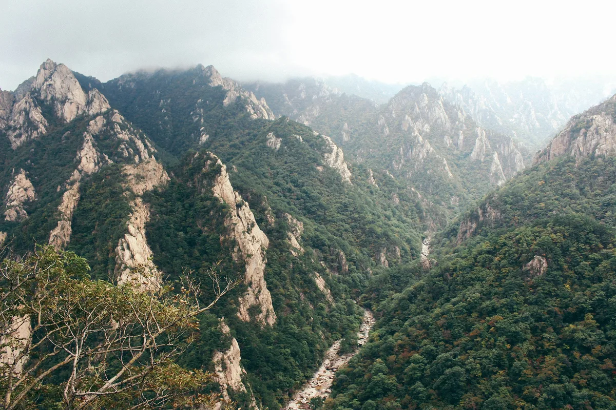
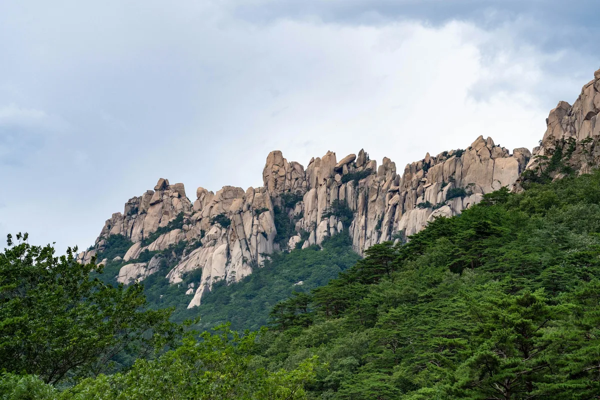
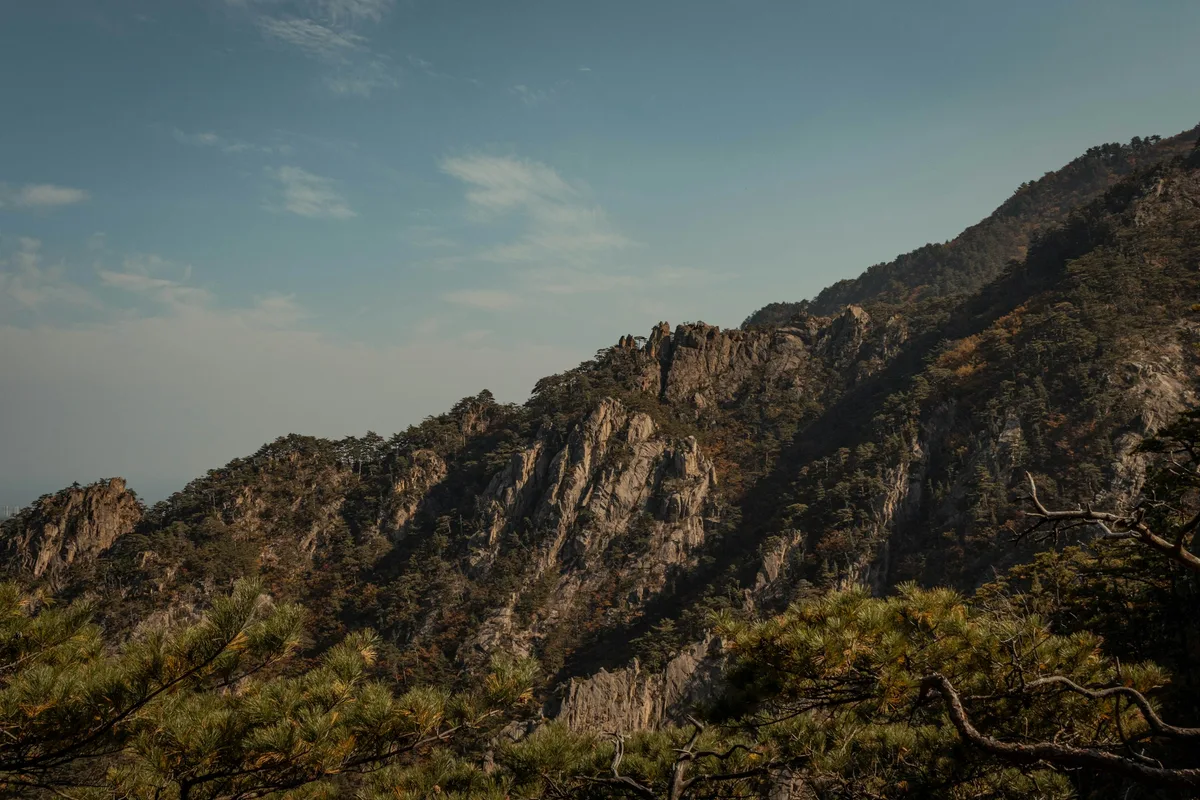
The geological foundation explains the scenery. Seoraksan's granite formed approximately 80 million years ago during the late Cretaceous — younger than Bukhansan's Jurassic-era Daebo Granite. Millions of years of differential erosion along dense joint systems carved the needle ridges, cliff valleys, and free-standing towers. Ulsanbawi is a massive single rock body sculpted by exfoliation and joint weathering. Dinosaur Ridge earned its name from the jagged sawtooth profile of its granite crest — a ridgeline formed by mechanical weathering of the granite body along closely spaced fracture planes.
The park also sits next to Sokcho, a coastal city on the East Sea. Combining a day in Seoraksan with fresh seafood in Sokcho is one of the better day-trip or overnight itineraries available from Seoul, and one that foreign visitors rarely find in generic travel guides.
The cultural layer runs deeper than most visitors expect. Sinheungsa Temple traces its origins to 652 CE, when the monk Jajang founded Hyangseonsa on the current site. The temple has been destroyed and rebuilt repeatedly, with the current incarnation dating to the Joseon period. Its Hyangseongsa Three-Story Stone Pagoda is a designated Treasure (No. 443). The 14.6-meter bronze Tongil Daebul at the entrance symbolizes reunification. Deeper in the park, Baekdamsa Temple — founded in 647 CE as Hangyesa — holds the memory of the poet-monk Manhae Han Yong-un, and Bongjeongam hermitage at 1,244 meters is one of Korea's five Jekmulbogung, enshrining Buddha's relics.
Compared to Bukhansan, where the trail is often crowded and the final rope section draws queues on weekends, Seoraksan's trail network is wider and more varied. The cable car option makes the lower viewpoints accessible to anyone, while the serious ridge routes like Dinosaur Ridge remain genuinely challenging. For Korea's highest summit, see Hallasan on Jeju Island.
Difficulty and Time Required
The gap between easy and hard at Seoraksan is significant. The cable car involves almost no physical effort. The Ulsanbawi trail is moderate overall but includes approximately 900 stairs in the final kilometer — more demanding than it sounds in warm weather. Daecheongbong is a serious mountain route: 1,320 meters of elevation gain on the shortest approach, with rangers enforcing departure time limits.
Dinosaur Ridge is in a different category entirely. The 18.2-kilometer loop from Sogongwon through the ridge and back via Cheonbuldong Valley takes 10 to 14 hours and involves sustained scrambling on exposed granite with rockfall risk. A helmet is recommended. The ridge is one of Korea's most challenging single-day routes.
The temperature at Daecheongbong is approximately 10 degrees Celsius colder than at the park entrance regardless of season. Weather changes rapidly at altitude — fog, lightning, and sudden wind are common from late morning onward.
If you are not sure which route suits you, start with Ulsanbawi. Most people in reasonable fitness complete it, and the summit view is the best available without committing to a full-day summit attempt.
Trail Options
Cable Car to Gwongeumseong — Easiest Option
The cable car runs from the main visitor area to approximately 700 meters elevation. From the upper station, a short walk leads to Gwongeumseong fortress ruins with panoramic views of the Cheonbuldong Valley, Ulsanbawi, and Sokcho city below. Total walking time is under 30 minutes from the cable car exit.
The cable car costs 16,000 KRW return for adults. On weekends and during the autumn foliage season, expect queues of two to three hours. Arriving before 9am or on a weekday significantly reduces wait time.
Best for: Families, visitors with limited mobility, anyone who wants the view without the climb.
Ulsanbawi Trail — Best Overall Route
The Ulsanbawi trail is 7.6 kilometers round trip with approximately 560 meters of elevation gain. Most people complete it in 3.5 to 4 hours. The route passes through Sinheungsa Temple, the Tongil Daebul bronze Buddha, and Heundeulbawi (a balancing boulder) before reaching the final staircase section.
Lower section — Sinheungsa to mid-mountain
The first 2.8 kilometers follow a river valley through shaded forest. The gradient is moderate and the path is well-paved. Families with children often turn back around this point. The Tongil Daebul — a 14.6-meter bronze Buddha against the mountain backdrop — is a notable landmark on this stretch. Gyejoam — a cave hermitage set into the cliff face — sits along this section and offers a glimpse of mountain Buddhism in practice.
Mid section — the staircase begins
From roughly the 2.8-kilometer mark, the trail becomes noticeably steeper. The path alternates between rocky steps and irregular stone, and on warm days the effort is considerable. A flat granite terrace about two-thirds of the way up offers space to rest and a clear view back down the valley.
Upper section — final 900 stairs
The last kilometer involves approximately 900 rock-carved steps ascending the granite wall. This section accounts for roughly half the total hiking time despite being a fraction of the distance. The effort is real, but the exposure is manageable and the handrails are continuous. From the summit, the view takes in surrounding peaks, Sokcho city, and the East Sea on clear days.
Best for: First-time visitors to Seoraksan, anyone wanting a proper hike without a full-day commitment.
Biryong Waterfall Trail — Best Easy Valley Hike
The Biryong Waterfall trail covers 2.8 kilometers one-way from the Sogongwon entrance along a valley floor through shaded forest. The gradient is gentle throughout, making it the best family-friendly option in the park after the cable car. The trail passes Yukdam Waterfall and a suspension bridge before reaching Biryong Falls at approximately 350 meters elevation — a 16-meter cascade with a 44-degree slope and a 16-meter-wide plunge pool at its base.
According to local legend, a dragon living in the pool behind the waterfall ascended to heaven after a maiden was offered as a sacrifice during a severe drought. The waterfall is at its most impressive in summer after heavy rain.
Allow approximately 3 hours round trip. The trail can be combined with the Ulsanbawi route for a longer day.
Best for: Families, visitors wanting a short valley walk, summer visitors seeking waterfall scenery.
Bisondae–Yangpok Valley — Cultural Valley Walk
From Sogongwon, this route follows the Cheonbuldong Valley upstream through some of the most historically layered terrain in the park. Bisondae — a broad granite slab where, according to legend, immortal beings descended to rest — bears calligraphic inscriptions by the master calligrapher Chusa Kim Jeong-hee. Waseondae, nearby, is where the immortals reclined. Further up the valley, Yangpok Waterfall and the series of deep pools and cascades known as Munjudam and Idanpokpo mark the lower section of the Cheonbuldong Valley — one of Korea's three great valleys, alongside Jirisan's Chilseon Valley and Hallasan's Tamra Valley.
The valley trail is well-maintained and mostly flat for the lower sections, becoming progressively steeper as it approaches the upper valley toward Huiungak Shelter. Most visitors do the lower section as a 3-to-4-hour round trip without attempting the full valley ascent.
Best for: Visitors interested in Seoraksan's mythology and cultural history, valley photography, hikers wanting a moderate alternative to Ulsanbawi.
Daecheongbong Summit — Serious Option
Daecheongbong at 1,708 meters is the park's highest point and one of the most demanding day hikes in Korea. The shortest approach is from Osaek (Route C), covering 9.5 kilometers round trip with 1,320 meters of elevation gain. Allow 6 to 8 hours. The gradient is extreme — a relentless staircase ascent that tests knees and stamina.
The classic route starts from Osaek, summits Daecheongbong, then descends through the dramatic Cheonbuldong Valley to the main park entrance — a 16.6-kilometer point-to-point trail that requires coordinating transportation from both ends. This is the definitive Seoraksan experience for summit hikers: sunrise from the eastern approach, the exposed summit plateau, and a dramatic descent through one of Korea's finest valley systems.
An alternative approach via Bongjeong Valley (Route D, 20+ kilometers) is quieter and passes through temple sites, offering a more solitary experience with unique viewpoints.
Rangers actively enforce departure time limits on summit routes. If you arrive at the trailhead too late in the day, you will be turned back. Start before 8am for the longer routes. The Jungcheong Shelter at 1,664 meters near the summit requires advance reservation and books out weeks ahead during autumn season.
Best for: Experienced hikers, those doing overnight stays at Jungcheong Shelter (reservation required well in advance).
Dinosaur Ridge Loop — Expert Ridge Traverse
Dinosaur Ridge (Gongyong Neungseon) is Seoraksan's most demanding trail and one of the most challenging day hikes in Korea. The 18.2-kilometer loop from Sogongwon follows the jagged granite ridgeline between Bisondae and Huiungak Shelter, with sustained scrambling on exposed rock at approximately 1,200 meters elevation.
The ridge earned its name from the sawtooth profile of the granite crest — a dramatic series of peaks and gaps carved by mechanical weathering along closely spaced fracture planes. The exposure is real: significant drops on both sides in multiple sections, loose rock on some passages, and no escape route once committed to the ridge.
The loop can be combined with the Osaek approach for a 21-kilometer point-to-point traverse: ascending from Osaek to Daecheongbong, then descending along the Dinosaur Ridge to Sogongwon. This combination has been called "the best full-day hike in Seoraksan" by experienced trail guides.
Allow 10 to 14 hours for the loop. A helmet is recommended due to rockfall risk. The ridge is not appropriate for hikers without previous scrambling experience on exposed terrain. Rangers may restrict access during high winds or wet conditions.
Best for: Experienced hikers with scrambling confidence, photographers seeking Seoraksan's most dramatic scenery, those combining with Daecheongbong for the ultimate traverse.
Best for Most Travelers
If you have one day in Seoraksan and moderate fitness: Ulsanbawi trail. The 7.6-kilometer round trip takes 3.5 to 4 hours, delivers the best summit view available without an overnight stay, and passes through Sinheungsa Temple and Heundeulbawi along the way. Start by 8am on weekends to avoid crowds on the final staircase.
If you want a gentler half-day: Biryong Waterfall trail combined with the lower Bisondae area. Both are accessible, scenic, and family-friendly. Add the cable car to Gwongeumseong for the aerial view without the climb.
If you are an experienced hiker with a full day and an early start: the Osaek to Daecheongbong summit route puts you on the third-highest peak in South Korea. The elevation gain is serious — 1,320 meters in under 5 kilometers — but the summit experience is unmatched on any mainland Korean mountain.
Who Should Do This Hike
Seoraksan suits a wider range of visitors than Bukhansan. The cable car makes the park accessible without any hiking at all. The Ulsanbawi trail is appropriate for anyone in moderate fitness with proper footwear. The Biryong Waterfall trail works for families with young children. The Daecheongbong routes and Dinosaur Ridge are for experienced hikers with full-day time and the right preparation.
The park is not suitable for casual footwear on anything beyond the cable car area. The granite stairs on Ulsanbawi become genuinely slippery after rain. Winter visits require crampons on the upper sections, and the temperature at Daecheongbong is approximately 10 degrees Celsius colder than at the park entrance regardless of season.
The Manchurian goral — a goat-antelope classified as Endangered Wildlife Grade I and Natural Monument No. 217 — inhabits the rocky upper elevations. Approximately 300 individuals lived in the Seoraksan range, though recent mass die-offs linked to ASF (African Swine Fever) fence barriers and severe winter conditions have significantly reduced the population. Stay on designated trails to minimize disturbance to their habitat.
Tips Before You Go
- Bring at least 2 liters of water. There are no vendors or water sources inside the park once you pass the entrance area. For Daecheongbong routes, carry 3 liters.
- Hiking boots are essential for the Ulsanbawi upper section. Trail runners work but add risk on wet granite.
- Gloves help on the final stair section of Ulsanbawi, particularly on the descent.
- In winter, crampons are strongly recommended. The Ulsanbawi stairs become ice-covered from December onward. Daecheongbong summit area temperatures can be 10 degrees Celsius colder than at the base — bring wind-resistant layers even in summer.
- Some trails close seasonally — fire prevention closures apply November 1 to December 15 and March 2 to May 15. Check the Korea National Park Service website before visiting.
- Shelter reservations (Jungcheong, Huiungak, Socheong, Yangpok) must be booked through the national park reservation system. Autumn foliage season books out at least one month in advance.
- Off-trail hiking carries a 500,000 KRW fine. The entire Seoraksan Natural Protection Area is Natural Monument No. 171. Stay on designated paths.
- Emergency location markers are installed every 500 meters in "n-n" format — call 119 and read out the marker number for precise rescue location. AEDs are available at all major shelters.
- Seoraksan National Park office: 033-801-0900. National Park hotline: 1670-9201.
How to Get There
From Seoul (bus — recommended): Take an express bus from Seoul Express Bus Terminal to Sokcho Bus Terminal. Buses run every 30 minutes, journey time approximately 2 hours 20 minutes. From Sokcho terminal, walk one minute to the nearby bus stop and take Bus 7-1 directly to Seoraksan National Park entrance. Total travel time from central Seoul is approximately 3 hours.
From Dong Seoul Terminal: Also available, but the Seoul Express Terminal offers more frequent departures and lower fares.
Osaek trailhead (for Daecheongbong): From Yangyang Bus Terminal or by car via the Osaek area in the park's southern section. Buses from Sokcho to Osaek run less frequently — confirm the schedule before planning.
By car: Approximately 190km from Seoul via expressway, 2 hours 20 minutes in normal traffic conditions. Parking is available at the Sogongwon entrance and at Osaek.
Use Naver Maps for real-time transit directions on the day — Bus 7-1 from Sokcho runs every 30 minutes.
Final Thoughts
If you are visiting Korea in autumn and have time for one overnight trip from Seoul, Seoraksan is the answer. The foliage peaks in early to mid-October, when the granite towers of Ulsanbawi rise above a canopy of red and orange maple. It is one of the more photographed landscapes in Korea for good reason.
For a full-day itinerary, combine the Ulsanbawi hike in the morning with a visit to Sokcho's Abai Village and the seafood market in the afternoon — the contrast between mountain trail and coastal town is one of the better combinations in Gangwon Province. For a multi-day trip, pair Seoraksan with Odaesan's fir forest in Pyeongchang or the coastal scenery of Gangneung.
For the best hikes reachable directly from Seoul, explore the full Seoul hiking guide — all mountains covered by subway.
Related Guides
Explore more hiking in Korea:
- Best hikes in Seoul — full overview of Seoul's mountains by subway
- Bukhansan Baegundae Hiking Guide — Seoul's highest summit
- Dobongsan Hiking Trail — granite ridge north of Seoul
- Odaesan Hiking Guide — fir forests and Buddhist heritage in Gangwon
- Chiaksan Hiking Guide — national park near Wonju, Gangwon Province
FAQ
How difficult is the Seoraksan hiking trail to Ulsanbawi? The Ulsanbawi route is rated medium difficulty. The lower 2.8 kilometers are moderate, but the final kilometer involves approximately 900 granite stairs. Most people in reasonable fitness complete the round trip in 3.5 to 4 hours.
What is the best time to visit Seoraksan National Park? Early to mid-October is peak season for autumn foliage, when the maple and deciduous forest turns orange and red against the granite peaks. Spring (April to June) is also excellent for clear skies and wildflowers. Avoid late July and August for the main trails due to heat and humidity.
How do I get to Seoraksan from Seoul? Take an express bus from Seoul Express Bus Terminal to Sokcho (approximately 2 hours 20 minutes), then Bus 7-1 from Sokcho terminal to the park entrance (30 minutes). Total journey time is around 3 hours.
Is the Seoraksan cable car worth it? Yes, particularly for visitors with limited time or fitness. The cable car reaches 700 meters elevation and provides panoramic views of the valley, Ulsanbawi, and Sokcho. On weekends and during autumn season, expect queues of 2 to 3 hours — arrive early.
Can I hike Seoraksan and Daecheongbong in one day? The shortest Daecheongbong route (Osaek, 9.5km round trip) is achievable in one long day with an early start. Rangers enforce departure time limits — start before 8am. The classic Osaek-to-Sogongwon traverse (16.6km) requires coordinating transport between trailheads.
What should I bring for Seoraksan hiking? Bring at least 2 liters of water, proper hiking footwear, a windbreaker, and snacks. In winter, crampons are essential. There are no food or water vendors inside the park. For Daecheongbong, bring 3 liters of water and a headlamp.
What is Dinosaur Ridge on Seoraksan? Dinosaur Ridge (Gongyong Neungseon) is an 18.2-kilometer loop traversing a jagged granite ridgeline at approximately 1,200 meters. It is one of Korea's most challenging day hikes, requiring scrambling experience and 10 to 14 hours. A helmet is recommended due to rockfall risk.
Continue exploring Korea's mountains
More routes, same honest field notes.
Related guides

Nearby hikes
HardChiaksan Hiking Guide: Birobong and Guryongsa Trail
A practical guide to hiking Chiaksan National Park near Wonju — the Guryongsa route to Birobong summit at 1,288m, Ladder Ridge scrambling, and Seoul access.

Nearby hikes
ModerateOdaesan Hiking Guide: Fir Forest and Birobong
A practical guide to hiking Odaesan National Park in Pyeongchang — the Birobong summit at 1,563m, Woljeongsa fir forest, Sogeumgang Gorge, and Seoul access.

Nearby hikes
ExpertTaebaeksan Hiking Guide: Cheonjedan Altar and Snow
A practical guide to hiking Taebaeksan National Park — Korea's sacred mountain with the Cheonjedan heaven altar, winter snow flowers, and yew grove trails.