Hiking in Seoul: Best Mountains, Trails, and Tips
A practical guide to hiking in Seoul — nine mountains from beginner-friendly peaks to serious granite scrambles, all reachable by subway from the city center.
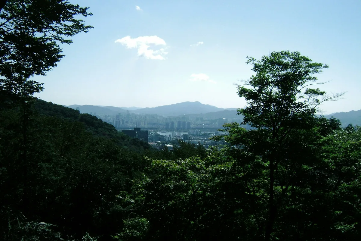
Seoul is one of the few cities in the world where a subway ride drops you at the base of a granite peak. Within 30 to 60 minutes from the city center, you can be standing on a ridge with the Han River below and the full Seoul skyline behind you. There are no entrance fees, the trail signs are bilingual, and the mountains are genuinely varied — from short sunset walks to full-day scrambles on exposed rock.
About 67% of Seoul's land area is hills and mountainous terrain, and the city's location was chosen in 1394 specifically because of this geography: four mountains surround the historic center, and the outer peaks form a natural defensive ring. Nine of those mountains are covered in this guide — each reachable by subway, each free to enter, and each offering a meaningfully different experience.
Quick Info
Quick summary for planning your Seoul hiking trip at a glance.
- Location: Seoul Metropolitan Area, South Korea
- Access: All major trails reachable by subway + short walk or bus
- Entrance Fee: Free (all mountains listed)
- Best Seasons: April–June (spring), October–November (autumn)
- Trail Signs: Korean and English throughout
- Emergency: 119 (mountain rescue), 112 (police)
Why Seoul Is Unusual for a Capital City
Most major capitals have parks. Seoul has mountains — real ones, with granite ridges, fixed rope sections, and 800-meter summits — sitting directly inside the city boundary. The four guardian mountains that surround the historic center were the reason this site was chosen as the capital in 1394, and the outer peaks beyond them form a natural defensive ring that shaped the city's military and spiritual identity for centuries.
What this means for hikers is unusual: you get the infrastructure of a world-class city and the access of a mountain town at the same time. Gear rental is available near major trailheads, cafes and restaurants cluster at the base of every trail, and the subway gets you within walking distance of most entry points. Compared to hiking near Tokyo or London, the raw access here is in a different league.
Best Mountains in Seoul
Bukhansan — Best Overall
At 836.5 meters, Bukhansan is the highest point in Seoul and the most visited national park by area in the world. The Baegundae route involves fixed metal ropes on exposed granite near the summit — not technically difficult, but physically demanding. The views from the top take in the full city in every direction.
Best for: Serious day hikers, summit experience, first-time visitors who want the full Seoul hiking experience.
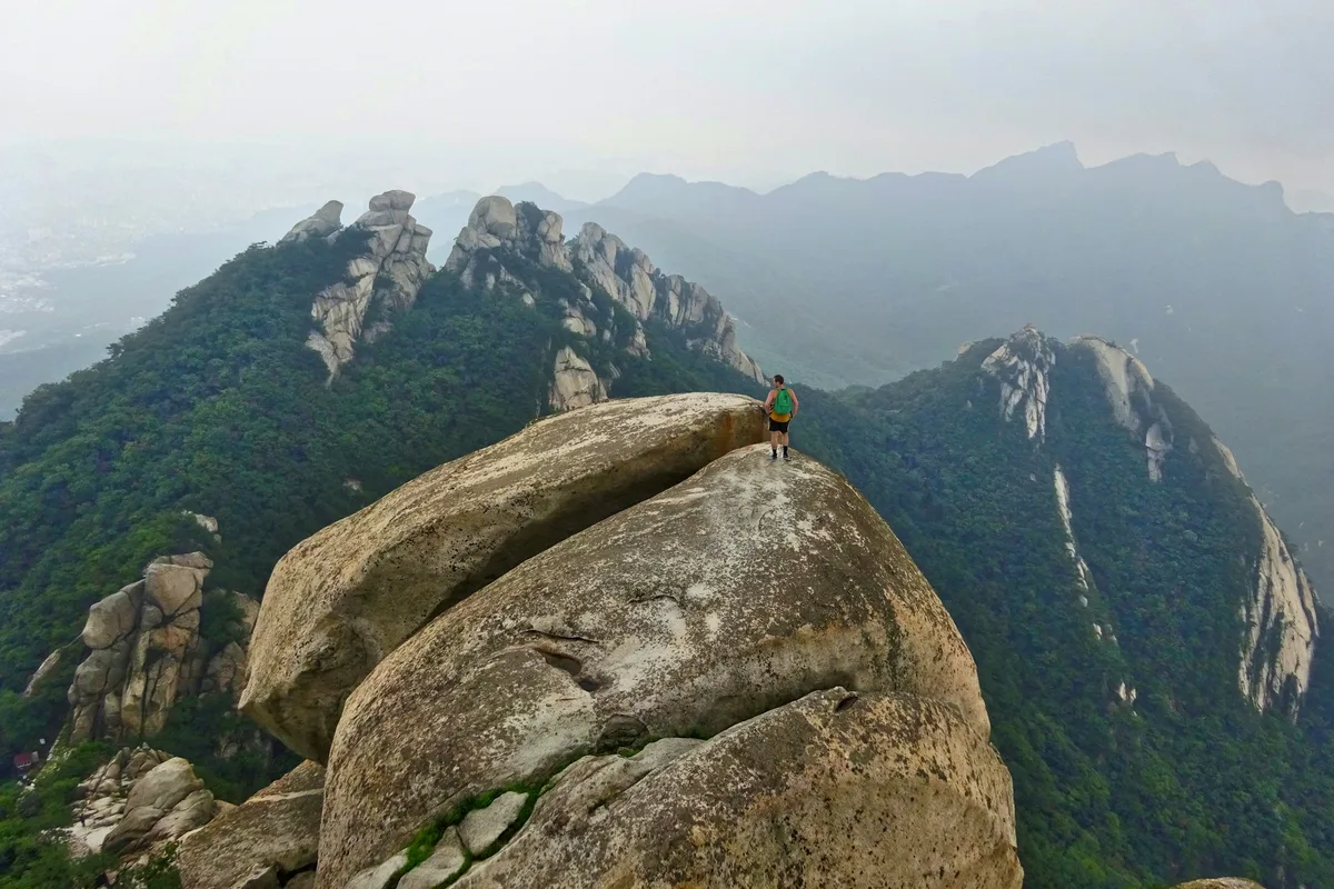
Dobongsan — Best for Ridge Scrambling
Dobongsan sits just north of Bukhansan and shares the same granite character, but with sharper towers and more exposed ridge sections. Crowds are noticeably lighter than Bukhansan on weekdays. The approach from Dobongsan Station is direct, and the upper sections feel like a proper mountain rather than a city trail.
Best for: Experienced hikers, those who want a serious ridge with fewer people.
Gwanaksan — Best Southern Option
At 632 meters, Gwanaksan anchors the southern edge of Seoul with steep stair sections, rocky viewpoints, and a cliffside temple halfway up. The Seoul National University Station approach is clean and direct. The summit view catches the southern skyline from an angle most visitors never see.
Best for: Hikers based in southern Seoul, those who want a challenging climb without going north.
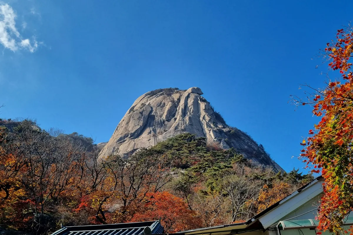
Inwangsan — Best for Sunset and Culture
Inwangsan is the shortest serious hike in this list at 338 meters, but it packs in more per kilometer than most — exposed granite boulders, sections of the 600-year-old Hanyang City Wall, and views that face directly toward Bukhansan and Namsan Tower. The trail is illuminated in the evening, making it the best option for a late-afternoon start.
Best for: First-time hikers, cultural interest, evening and night hiking.
Namsan — Best for Casual Visitors
Namsan is 262 meters and better known as the hill beneath N Seoul Tower. It is the most forgiving hike in the city and the easiest to combine with sightseeing. A cable car runs to the top if you prefer not to walk. The summit offers a 360-degree view of central Seoul.
Best for: Tourists, families, non-hikers who still want a view.
Achasan — Best for Han River Views
Achasan is a low ridge (287 meters) on the eastern edge of Seoul. The trail stays mostly flat once you are on the ridge, and the view directly down to the Han River is the clearest and most open in the city. Particularly good at sunset and after dark — the trail is well-lit and popular with evening walkers.
Best for: Sunset hikes, beginners, Han River views, night hiking.
Suraksan — Best for Technical Scrambling
Suraksan is 638 meters tall and sits at Seoul's northern edge. The defining feature is Gichabawi (Train Rock) — a 20-meter near-vertical granite wall with fixed ropes that makes this the most technically demanding mountain accessible by Seoul subway. The Jangam-to-Suraksan Station traverse covers 8 kilometers with genuine rock scrambling sections throughout.
Best for: Experienced hikers wanting technical terrain, anyone who has done Bukhansan and Dobongsan and wants more.
Bulamsan — Best for Azaleas and Northeast Seoul
Bulamsan is 510 meters on the boundary of Nowon-gu and Namyangju, connected to Suraksan via Deokneung Pass. The summit is a Jurassic granite dome with rope-assisted scrambling on the upper ridge. In late April and early May, roughly 100,000 azalea bushes bloom across the ridge — the most concentrated spring display on any Seoul mountain. The Sanggye route from Line 4 delivers a proper summit in under two hours.
Best for: Northeast Seoul access, spring azalea season, granite scrambling, Suraksan traverse connection.
Cheonggyesan — Best for Gangnam Access
Cheonggyesan is 618 meters and sits southeast of Seoul, accessible from Gangnam in 20 to 30 minutes by Shinbundang Line. The Wonteogol Valley route follows a stream through dense forest with natural mineral springs — a forested, quiet contrast to the granite northern peaks. The full ridge traverse visits multiple peaks with historical Joseon and Goryeo associations.
Best for: Gangnam-based visitors, families, forested valley hiking, moderate half-day commitment.
Trail Comparison Table
| Mountain | Height | Time | Difficulty | Best For |
|---|---|---|---|---|
| Bukhansan | 836m | 3.5–5h | Hard | Summit, full-day hike |
| Dobongsan | 740m | 4–6h | Hard | Ridge scrambling |
| Gwanaksan | 632m | 3–4.5h | Medium-Hard | Southern Seoul, temples |
| Inwangsan | 338m | 1.5–2.5h | Easy-Medium | Sunset, fortress walls |
| Achasan | 287m | 1–2h | Easy-Medium | Han River views |
| Suraksan | 638m | 5–5.5h | Hard | Technical scrambling |
| Bulamsan | 510m | 3–3.5h | Easy–Moderate to Moderate–Hard | Azaleas, granite scrambling |
| Cheonggyesan | 618m | 2.5–5h | Easy–Medium | Gangnam access, forested |
| Namsan | 262m | 1–2h | Easy | Tourists, casual walk |
How to Get to Seoul's Mountains
| Mountain | Nearest Station | Line |
|---|---|---|
| Bukhansan (east) | Bukhansan Ui Station | Ui-Sinseol Line |
| Bukhansan (west) | Gupabal Station + Bus 34/704 | Line 3 |
| Dobongsan | Dobongsan Station | Line 1 / Line 7 |
| Gwanaksan | Seoul Nat'l University Station | Line 2 |
| Inwangsan | Gyeongbokgung Station | Line 3 |
| Namsan | Myeongdong Station | Line 4 |
| Achasan | Achasan Station | Line 5 |
| Suraksan | Suraksan Station / Jangam Station | Line 7 |
| Bulamsan | Sanggye Station / Hagye Station | Line 4 / Line 7 |
| Cheonggyesan | Cheonggyesan-ipgu Station | Shinbundang Line |
Use Naver Maps or Google Maps for real-time routing on the day — transfer times vary depending on your starting point.
Tips Before You Go
- No food or water is available inside most parks. Bring at least 1.5 liters of water regardless of trail length.
- Start before 8am on weekends for Bukhansan and Dobongsan — crowds on the upper sections can be significant by 10am.
- Proper hiking shoes are required for anything above easy difficulty. The granite surfaces become dangerous when wet.
- In winter, crampons are strongly recommended for Bukhansan and Dobongsan. They are available for purchase near major trailheads.
- Trail closures and seasonal restrictions may apply. Check the Korea National Park Service website before visiting.
- Gear rental (boots, poles, crampons) is available free of charge at the Seoul Hiking Tourism Center near Bukhansan Ui Station.
Best Time to Hike in Seoul
Spring (April to June) brings clear skies, mild temperatures, and wildflowers along the lower trails. Autumn (October to November) is the most popular season — the granite peaks contrast sharply against red and orange foliage, and October is the peak month for color. Summer is hot and humid, though the valley sections of Bukhansan provide some relief. Winter hiking is possible with the right gear and offers the best photography conditions on snow-covered granite.
Final Thoughts
If you only have time for one hike in Seoul, Bukhansan Baegundae is the answer. But if you have more than a day, Inwangsan at sunset and Achasan in the evening give you a different side of the city — quieter, lower, and built around the view rather than the summit.
For visitors staying longer, the Hanyang City Wall trail connects four of the inner mountains in a single 18.6-kilometer circuit — one of the best urban hiking routes in Asia.
Related Guides
Explore individual trail guides:
- Bukhansan Baegundae Hiking Guide — Seoul's highest summit
- Dobongsan Hiking Trail — granite ridge with fewer crowds
- Gwanaksan Hiking Guide — rugged southern option
- Inwangsan Hiking Guide — city wall hike near Gyeongbokgung
- Namsan Hiking Guide — N Seoul Tower, central Seoul
- Achasan Hiking Guide — Han River views, sunrise
- Suraksan Hiking Guide — technical scrambling, Gichabawi
- Bulamsan Hiking Guide — azaleas and granite, northeast Seoul
- Cheonggyesan Hiking Guide — forested trails from Gangnam
FAQ
Is hiking in Seoul suitable for beginners? Yes. Mountains like Namsan, Achasan, and Inwangsan are accessible to most fitness levels with minimal gear. Bukhansan and Dobongsan require more preparation and proper footwear.
What is the best mountain to hike in Seoul? Bukhansan Baegundae is the most complete experience — highest summit, best views, and the most dramatic trail. For beginners, Inwangsan or Achasan are better starting points.
Do I need a guide to hike in Seoul? No. All major trails are well-marked in Korean and English, and navigation apps like Naver Maps and AllTrails cover the routes in detail.
When is the best time to go hiking in Seoul? April to June and October to November offer the best conditions. October is peak season for autumn foliage. Avoid typhoon season in late July and August if possible.
Can I hike in Seoul in winter? Yes, but bring crampons for icy sections on Bukhansan and Dobongsan. Winter mornings offer excellent visibility and far fewer crowds than weekends in autumn.
How do I get to hiking trails in Seoul without a car? Every major trail is reachable by subway. Most trailheads are within a 10–30 minute walk from the nearest station. Use Naver Maps for the most accurate transit directions.
Related guides

Nearby hikes
EasyAchasan Hiking Guide: Han River Views and Sunrise
A practical guide to hiking Achasan in Seoul — the main summit route, the Achasan-Yongmasan ridge traverse, Han River sunrise views, and subway directions.

Nearby hikes
HardBukhansan Hiking Guide: Baegundae Summit in Seoul
A practical guide to hiking Bukhansan National Park in Seoul — Baegundae summit routes, Bukhansanseong Fortress, Insubong rock climbing, and subway access.

Nearby hikes
ModerateBulamsan Hiking Guide: Granite Ridge and Azaleas
A practical guide to hiking Bulamsan in northeast Seoul — the Sanggye route, Hwangangdae technical scramble, spring azaleas, and how to get there by subway.