Wolchulsan Hiking Guide: Cloud Bridge and Summit
A practical guide to hiking Wolchulsan National Park — Korea's smallest national park, the iconic 52-meter Cloud Bridge, and the Cheonhwangbong summit route.

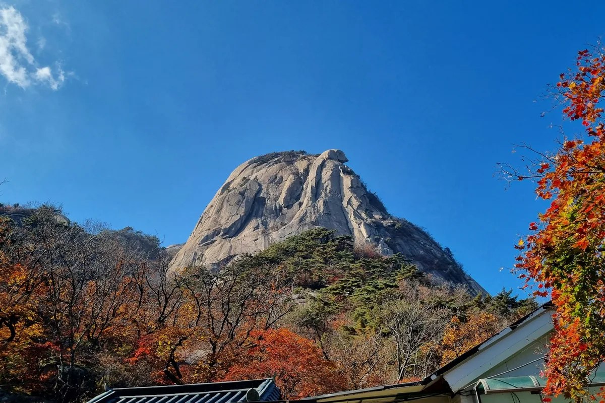
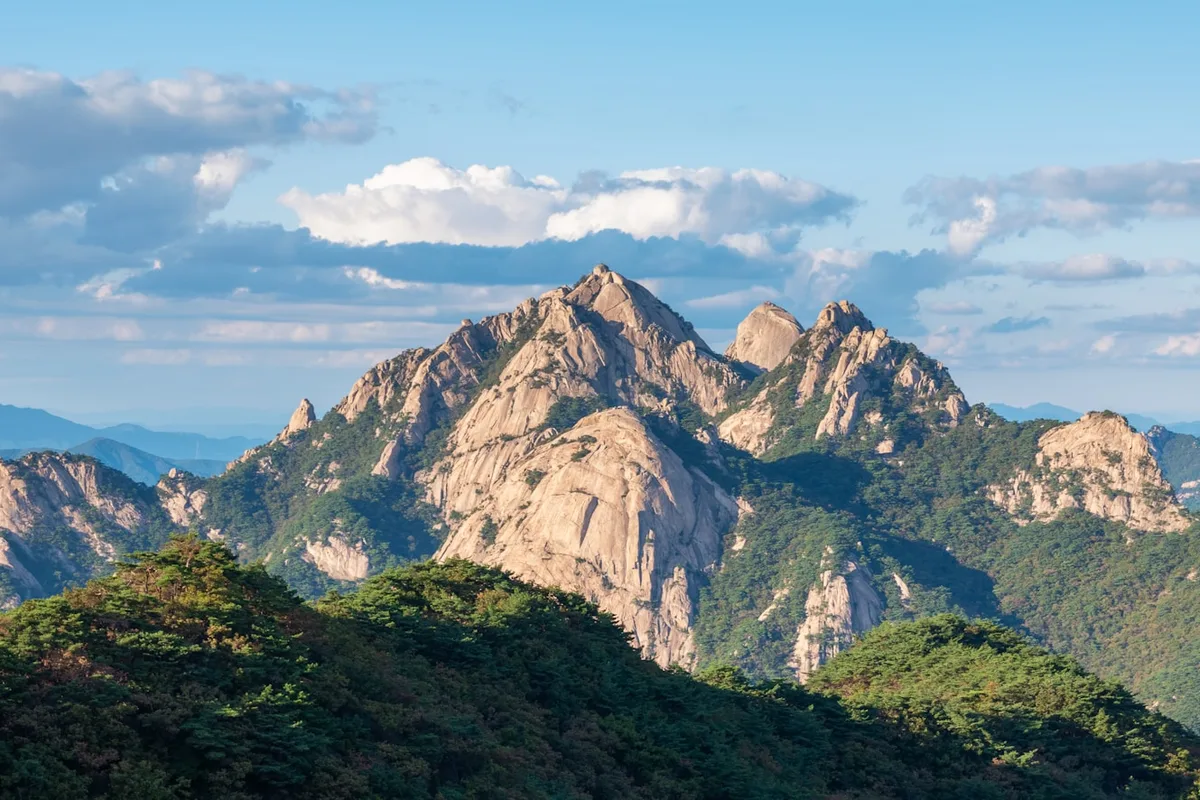
Wolchulsan is the smallest national park in South Korea. At 56.6 square kilometers it is a fraction of the size of Jirisan, and its highest summit — Cheonhwangbong at 809 meters — is lower than most peaks in this guide. But the mountain is famous for a different reason: the granite. Wolchulsan rises abruptly from the flat plains of southern Jeolla-do, and the 45-degree rock faces, narrow ridges, and exposed summits are so unusual that the mountain has been called the "Small Kumgang of Honam" — a reference to the legendary granite range in the North.
The signature feature is the Cloud Bridge. A 52-meter red suspension bridge hangs 120 meters above the ground, connecting Maebon and Sajabong at an altitude of roughly 510 meters. It is the most photographed bridge in Korean hiking and the reason most visitors come. Reaching it takes 1.5 to 2 hours of chain-assisted scrambling from the Cheonhwangsa trailhead.
The park was designated in 1988 as Korea's 20th national park. It spans Yeongam-gun and Gangjin-gun in Jeollanam-do, and it is geologically distinctive: a Late Cretaceous granite batholith that has resisted erosion while the surrounding softer rock was worn down to flatland over roughly 100 million years. The result is a silhouette that looks, from the plains, like a separate country.
Two historic temples anchor the base. Dogapsa on the north side was founded in 881 CE by the monk Doseon and holds multiple National Treasures including the Haetalmun gate. Muwisa on the south side, reportedly founded in the 7th century, contains a 13th-century Amitabha triptych wall painting designated National Treasure No. 313. And in the foothills is the birthplace of Wangin, the Baekje-era scholar who reportedly carried the Analects and the Thousand Character Classic to Japan — one of the earliest documented transmissions of Confucian learning across the sea.
Quick Info
Quick summary for planning your Wolchulsan hike at a glance.
- Location: Yeongam-gun / Gangjin-gun (Jeollanam-do), South Korea
- Highest Peak: Cheonhwangbong, 809m
- Park Area: 56.6 km² (Korea's smallest national park)
- Park Designation: 20th National Park (1988)
- Rock Type: Granite (Late Cretaceous batholith, ~100 million years)
- Difficulty: Hard (most routes involve exposed scrambling and chains)
- Signature Feature: Cloud Bridge — 52m long, 120m above ground, ~510m elevation
- Best Time to Visit: April–May (azaleas), October (foliage, cool weather)
- Entrance Fee: Free
- Parking: ~₩2,000–4,000
- Travel Time from Seoul: ~3–3.5h by car, 5–6h by public transit
Trail Overview
| Trail | Distance | Elevation Gain | Time | Difficulty | Best For |
|---|---|---|---|---|---|
| Cloud Bridge Circuit | 4–5km loop | +500m | 2.5–3h | Moderate–Hard | Iconic bridge, photography |
| Cheonhwangbong Summit | 2.5–3km one-way | +500m | 2–3.5h round trip | Hard | Peak views, short hard hike |
| Dogapsa ↔ Cheonhwangsa Traverse | 9–10km | +700m cumulative | 6–7h | Advanced | Full ridge, two temples |
| Gyeongpodae Valley | 5–6km | moderate | 2–3h | Easy | Valley walk, easier option |
Why Wolchulsan Is the Mountain That Punches Above Its Size
On paper, Wolchulsan should not be memorable. It is the smallest national park in the country, its summit is modest by Korean standards, and the park can be crossed end-to-end in a single day. But the geology does something unusual here, and it changes everything.
Most Korean mountains are part of a continuous upland — Jirisan fades into neighboring ridges, Seoraksan into the Taebaek range. Wolchulsan does not. The mountain rises as an isolated granite outcrop from a broad agricultural plain, and the contrast is so sharp that the silhouette is visible from dozens of kilometers away. This is differential erosion at full expression: a Late Cretaceous granite batholith that intruded the crust roughly 100 million years ago, then was uplifted and exposed while the softer surrounding rock washed away. What is left is a hard-edged cluster of peaks, cliffs, and narrow ridges with almost no soil on the upper slopes.
The granite also means the hiking is technical. Chain-assisted sections, rope sections, exposed rock steps, and a genuine suspension bridge at 120 meters above the ground are standard features on the main routes. Wolchulsan's peaks are modest in elevation but not modest in difficulty. A hiker coming here expecting an 800-meter walk will be surprised.
The cultural layers matter here as well. Wangin — the Baekje scholar who reportedly carried Confucian texts to Japan around the late fourth to early fifth century — was born in what is now Yeongam-gun, and the foothills hold the Wangin Historic Site at Seonggi-dong. Dogapsa and Muwisa are two of the older temple complexes in Jeollanam-do. The mountain's old names — Dalnasan in Baekje, Wollaak in Unified Silla, Wolchulsan from Goryeo onward — all reference the moon rising over its ridgeline, and the name has held for roughly a thousand years.
For comparison, Jirisan has more elevation and a larger ridge. Seoraksan has more famous granite spires in Ulsanbawi and the Cheonbuldong Valley. Naejangsan has better autumn foliage across a broader canopy. Wolchulsan has the most intense concentration of exposed granite and technical trail in the shortest distance — plus the Cloud Bridge, which no other Korean mountain has.
Difficulty and Time Required
Wolchulsan is difficult for its size. The 809-meter summit is modest, but almost every route involves chain-assisted climbing, rope sections, and significant exposure — and this is not optional terrain on the popular routes.
The Cloud Bridge Circuit is the most walked trail in the park. It is rated moderate-to-hard: 4 to 5 kilometers, around 500 meters of elevation gain, 2.5 to 3 hours. Reaching the bridge itself requires 1.5 to 2 hours of sustained climbing on stone steps followed by an exposed ridge section with chains. The bridge crossing takes 5 to 10 minutes including photos, and descent on the loop takes another 45 to 60 minutes. This is not a beginner route despite its popularity.
The Cheonhwangbong Summit Route is shorter but harder: 2.5 to 3 kilometers one way, 1.5 to 2 hours up, 1.5 hours down. The final segment to the summit involves 2 to 3 rope-assisted sections, rock scrambling on 45-plus degree slopes, and a final 50-meter scramble to the top. Exposure is significant.
The Dogapsa-Cheonhwangsa Traverse is the full ridge: 9 to 10 kilometers, 6 to 7 hours, roughly 700 meters of cumulative elevation gain across multiple peaks. This is the park's major undertaking and should only be done by fit, experienced hikers with a full day of daylight and settled weather.
Gyeongpodae Valley is the gentle option — a roughly 5 to 6-kilometer valley walk, 2 to 3 hours, with no significant scrambling. This is where families, older hikers, and anyone with height anxiety should start.
Winter is hazardous. Ice on granite is lethal, and several chain sections become unusable when frozen. Unless you have winter mountaineering experience, hike Wolchulsan from April through November.
Trail Options
Cloud Bridge Circuit — The Signature Route
The trail most visitors come for. From the Cheonhwangsa trailhead, a 4 to 5-kilometer loop climbs stone steps to the ridge, crosses the Cloud Bridge, and descends via an alternative ridge back to the starting point. Roughly 500 meters of elevation gain, 2.5 to 3 hours not including rest stops.
The trail breaks into four segments: a 15 to 20-minute stair climb to the Mountain Gate, a 45 to 60-minute ridge ascent with chain-assisted rock sections to the bridge approach, the bridge crossing itself, and a 45 to 60-minute descent on a separate ridge.
The bridge is 52 meters long, 120 meters above the ground, and built of red-painted steel with a metal-grating walkway and handrails on both sides. It can sway noticeably in strong wind, and on weekends and peak holidays, bridge queues regularly hit 20 to 30 minutes. On October weekends, wait times of an hour or more are not unusual. Weekdays are materially less crowded.
Wear proper hiking boots — the chain sections require grip — and do not attempt this trail in wet conditions. Granite is extremely slippery when wet, and the exposure is serious.
Best for: Most visitors, the iconic Wolchulsan experience, photographers, day trippers from Mokpo or Gwangju.
Cheonhwangbong Summit Route — Highest Peak, Hardest Short Hike
From Cheonhwangsa, a direct 2.5 to 3-kilometer ascent to the 809-meter summit via Jujibong. Elevation gain around 500 meters, 1.5 to 2 hours up, 1.5 hours down.
The first kilometer climbs steep stone steps with chains. The second kilometer crosses to Jujibong and then begins the technical section: 2 to 3 rope-assisted rock segments, 45-plus degree scrambling, and a final 50-meter rock push to the summit platform. Exposure on the southern side is significant — a fall would be consequential.
The summit itself is a rock platform with 360-degree views: Yeongam City and the Yellow Sea to the north, Gangjin County and the southern coast to the south, interior Honam ranges to the east, and the coastal plain to the west. Allow 20 to 30 minutes at the top before descending.
Return options: same route back (1.5 hours, familiar terrain) or via Gujeongbong on an alternative ridge (around 2 hours, more scrambling, for experienced hikers).
Best for: Fit hikers who want the actual summit, short-but-intense day hikes, experienced scramblers.
Dogapsa ↔ Cheonhwangsa Traverse — The Full Ridge
A 9 to 10-kilometer point-to-point traverse of the main ridge, starting from Dogapsa Temple, crossing Gujeongbong and Cheonhwangbong, and descending to Cheonhwangsa. Cumulative elevation gain around 700 meters, 6 to 7 hours, advanced.
The route splits into three phases: a 45-minute forest approach from Dogapsa to the first ridge junction, 2.5 to 3.5 hours of ridge traverse across multiple peaks with alternating scrambling and walking, and a 1.5 to 2-hour steep chain-assisted descent to Cheonhwangsa.
Gujeongbong is the midway highlight. The "Nine Pools" (Guji) are a series of natural water basins carved into granite — the largest fills seasonally into a small waterfall. The feature gives the peak its name (guji = "nine pools") and is one of the park's quieter photography spots, visited less than the Cloud Bridge.
The traverse is point-to-point, so arrange return transport in advance. A taxi between Dogapsa and Cheonhwangsa parking takes around 30 minutes. Water sources on the ridge are limited to seasonal pools; carry 2 to 3 liters.
Best for: Experienced hikers wanting the full mountain in one day, ridge walkers, Wolchulsan completionists.
Gyeongpodae Valley — The Gentle Option
A 5 to 6-kilometer valley walk reaching Gyeongpodae from its lower trailhead. Elevation gain is moderate, the route is 2 to 3 hours, and there is no scrambling. This is the park's best trail for families with young children, older hikers, and anyone with height anxiety who does not want to confront the Cloud Bridge's exposure.
The valley carries the Yeongam-cheon headwaters and is heavily shaded in summer, which makes it the coolest route on hot days.
Best for: Families, older visitors, summer hikers, anyone wanting to see Wolchulsan's scenery without the exposure of the main routes.
Cultural Visit: Dogapsa and Muwisa
Both temples are worth a stop regardless of which trail you hike.
Dogapsa Temple — Founded in 881 CE by the monk Doseon, extensively rebuilt in 1456 under King Sejo. The Haetalmun (main gate, National Treasure No. 50), and the Dogapsa Five-Story Stone Pagoda (Treasure No. 1433) are the main designated pieces. The temple sits on the north side of the park and is the trailhead for the full ridge traverse.
Muwisa Temple — According to tradition founded by the monk Wonhyo in 617 CE and rebuilt in 1555. The Geungnakjeon main hall (National Treasure No. 13) and its 13th-century Amitabha Buddha Triptych wall painting (National Treasure No. 313) are the highlights. Located on the south side in Gangjin County.
Temple entry fees typically run around ₩3,000–4,000 and are separate from park access.
Best for Most Travelers
If you have a half day: the Cloud Bridge Circuit from Cheonhwangsa — the signature experience of the mountain. 4 to 5 kilometers, 2.5 to 3 hours, chain-assisted but manageable for most hikers in decent fitness.
If you have a full day: the Cloud Bridge Circuit plus a summit push to Cheonhwangbong — adds about 2 kilometers and 2 hours round trip from the Cloud Bridge area.
If you have a full day and experience: the Dogapsa ↔ Cheonhwangsa Traverse — the whole park in one crossing.
If height or exposure is a concern: Gyeongpodae Valley plus a stop at Dogapsa or Muwisa Temple.
If you are not sure: start with the Cloud Bridge Circuit on a weekday.
Who Should Do This Hike
Wolchulsan is a mountain for hikers who want density, not distance. The peaks are short, the summit is lower than most in this guide, but the rock scrambling, chain sections, and exposure rival anything on Korea's more celebrated ranges. In two hours, you cross more technical terrain here than in a full day at Bukhansan's Baegundae.
The Cloud Bridge itself is the draw for casual visitors — a photo opportunity with a short but intense approach. It is accessible to most adults in reasonable fitness, but it is not a beginner route. Anyone with significant height anxiety should skip the Cloud Bridge entirely and take Gyeongpodae Valley.
Cheonhwangbong is a summit for fit, experienced hikers. The combination of 500 meters of elevation in 2.5 kilometers and rope-assisted rock scrambling on exposed granite means it earns its "Hard" rating despite the modest total distance.
The full traverse belongs on a list of advanced Korean day hikes. It is shorter than Jirisan's or Seoraksan's signature traverses but more sustained in its technical demand per kilometer.
Families with young children should go to Gyeongpodae Valley and the temples. Do not bring small children to the Cloud Bridge.
Tips Before You Go
- Weekday visits significantly reduce crowding. Cloud Bridge waits of an hour or more are common on October weekends; Tuesday to Thursday is markedly better.
- Never hike in wet conditions. Granite is extremely slippery when wet, and many of the chain sections become dangerous. Wait several hours after rain before attempting the main routes.
- Winter is technical. Ice on granite is lethal and chain sections can freeze. If you do not have winter mountaineering experience, hike Wolchulsan between April and November.
- Carry 2 to 3 liters of water. No reliable water sources on ridge routes.
- Start early — especially in summer when afternoon thunderstorms build. Lightning on an exposed granite ridge is a real risk. If you hear thunder, descend immediately.
- Wind — the Cloud Bridge sways noticeably in strong wind. On days with gusts above 40 km/h, consider alternative routes. Park staff will close the bridge in extreme wind.
- Height anxiety — be honest with yourself before starting. The exposure on the Cloud Bridge and the summit approach is not minor. Gyeongpodae Valley is the right choice if heights are a concern.
- Helmets are not commonly used on Wolchulsan but are not unreasonable on the technical sections, especially in a group where people above may dislodge loose rock.
- Cell reception is limited on the ridge. Do not rely on phone signal for emergencies; leave an itinerary with someone off-mountain.
- Emergency numbers: 119 (ambulance/fire/rescue), 112 (police), Wolchulsan Ranger Station +82-61-463-4700.
- Temple entry fees are separate from park entry and typically run ₩3,000–4,000.
How to Get There
By car (from Seoul): Approximately 3 to 3.5 hours via the Seohaean Expressway to Yeongam-gun. Parking is available at Cheonhwangsa, Dogapsa, and Gyeongpodae trailheads (~₩2,000–4,000).
By KTX + local bus (from Seoul): KTX from Yongsan Station to Mokpo takes approximately 2 hours 30 minutes. From Mokpo, a local bus to Yeongam takes around 50 minutes; from Yeongam, taxi or shuttle to the trailhead takes 15 to 20 minutes. Total door-to-trailhead time is 4 to 5 hours.
By express bus: Seoul Central City Terminal to Yeongam Intercity Bus Terminal in approximately 4 to 5 hours. Local transit to the trailhead from there.
Between trailheads (for the full traverse): Dogapsa and Cheonhwangsa are on opposite sides of the park. A taxi between the two parking areas takes around 30 minutes. Arrange return transport before you start.
Use Naver Maps for real-time transit on the day — intercity bus schedules in Jeollanam-do can be infrequent and change seasonally.
Final Thoughts
Wolchulsan is the mountain that surprises people. It is small, the summit is low, and it can be crossed in a day. But the granite is as dramatic as anything else in Korea, and the Cloud Bridge — a 52-meter red suspension bridge hanging 120 meters above the ground — is an image that sticks.
The Cloud Bridge Circuit delivers the signature experience in under three hours. The Cheonhwangbong summit push gives you the highest point on an intense short day. The full traverse gives you the whole ridge. And the temples at the base — Dogapsa with its National Treasure gate, Muwisa with its 13th-century wall painting — anchor the mountain in a cultural history that stretches back to Baekje.
Wolchulsan rewards hikers who show up prepared. Chain sections, exposed ridges, and a 120-meter-high suspension bridge do not ease off for visitors.
For the best hikes reachable directly from Seoul by subway, see the full Seoul hiking guide.
Related Guides
Explore more hiking in Korea:
- Best hikes in Seoul — full overview of Seoul's mountains by subway
- Jirisan Hiking Guide — mainland Korea's highest summit and ridge traverse
- Seoraksan Hiking Guide — Korea's most famous hiking destination
- Hallasan Hiking Guide — Jeju Island's volcanic UNESCO triple-crown summit
- Naejangsan Hiking Guide — Korea's premier autumn foliage destination
FAQ
How difficult is the Cloud Bridge hike? Moderate to hard. The 4 to 5-kilometer circuit gains around 500 meters with sustained stone-step climbing and chain-assisted rock sections. The bridge itself is 120 meters above the ground and can sway noticeably in wind. Fit adults can complete it in 2.5 to 3 hours, but it is not a beginner route.
Is the Cloud Bridge safe? Yes, under normal conditions. The bridge is a 52-meter steel suspension bridge with handrails on both sides. Park staff close it in high winds. The approach trails have chain-assisted sections that require attention but are not technical climbing. Avoid wet conditions — granite becomes extremely slippery.
Can I hike Cheonhwangbong as a beginner? No. Despite the modest 809-meter elevation, the summit route involves rope-assisted rock scrambling, 45-plus degree slopes, and significant exposure. Choose Gyeongpodae Valley or start with the Cloud Bridge Circuit if you are new to hiking.
How do I get to Wolchulsan from Seoul? The fastest route is KTX from Yongsan Station to Mokpo (around 2 hours 30 minutes), then a local bus to Yeongam (about 50 minutes), then taxi to the trailhead (15–20 minutes). Driving takes about 3 to 3.5 hours via the Seohaean Expressway.
When is the best time to hike Wolchulsan? April to May for azaleas and comfortable temperatures; October for foliage and cool, dry weather. Avoid wet days year-round — the granite becomes dangerous. Winter requires technical experience due to ice on rock.
Is Wolchulsan worth visiting? Yes. It is Korea's smallest national park but arguably its most visually concentrated granite landscape, with the Cloud Bridge, an 809-meter technical summit, two historic temples with National Treasures, and the cultural heritage of the Baekje-era scholar Wangin. It rewards hikers who come prepared for exposed rock and chain-assisted terrain.
Continue exploring Korea's mountains
More routes, same honest field notes.
Related guides

Same region
EasyByeonsanbando Hiking Guide: Sea Cliffs and Naesosa
A practical guide to hiking Byeonsanbando — Korea's only peninsular national park, with Chaeseokgang UNESCO sea cliffs, Jikso Falls, and Naesosa fir forest.

Same region
ModerateDeogyusan Hiking Guide: Gondola Summit and Valley
A practical guide to hiking Deogyusan National Park in Muju — the gondola route to Hyangjeokbong summit at 1,614m, Gucheondong Valley, and winter rime flowers.

Same region
ModerateMudeungsan Hiking Guide: Columnar Joints and Trails
A practical guide to hiking Mudeungsan National Park in Gwangju — the Jeungsimsa trail, Seoseokdae columnar joints, UNESCO Geopark status, and Seoul access.