Juwangsan Hiking Guide: Tuff Cliffs and Jusanji Pond
A practical guide to hiking Juwangsan National Park — a UNESCO Global Geopark with volcanic tuff cliffs, three valley waterfalls, and willow-lined Jusanji Pond.

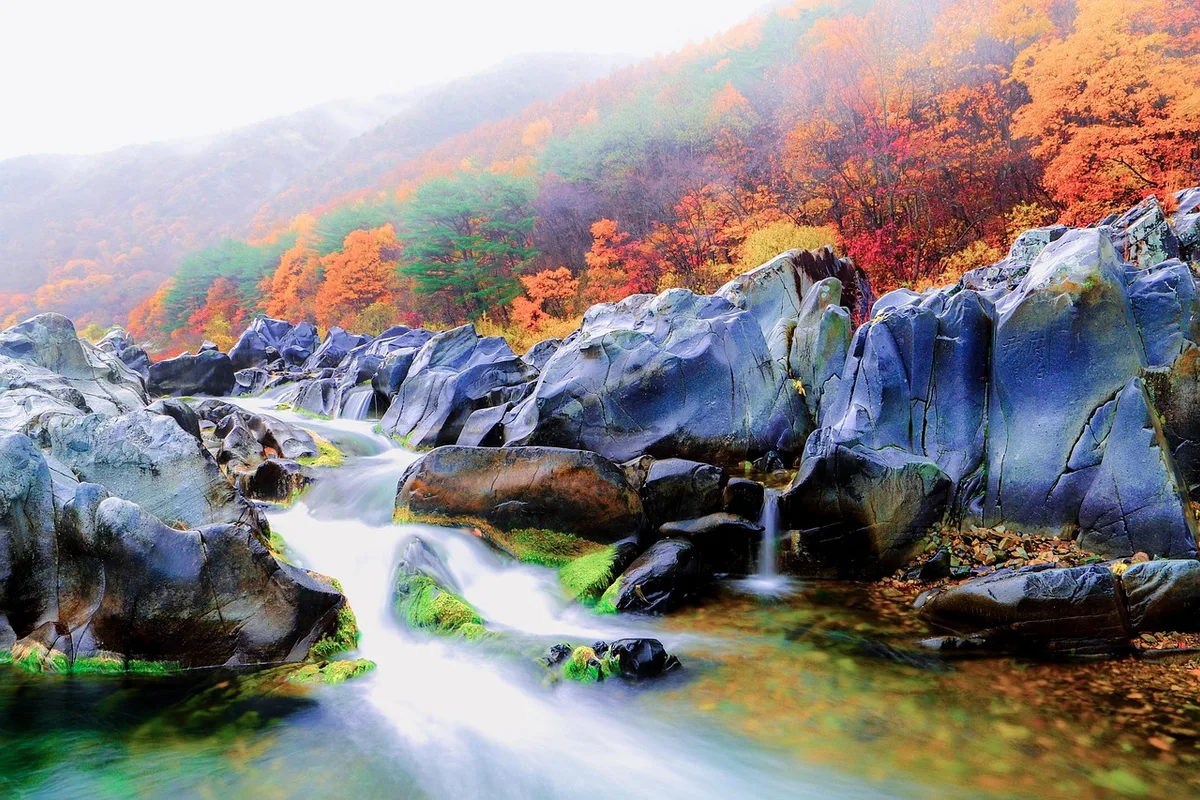
Juwangsan is Korea's geological theatre. At 720.6 meters the summit is modest by national-park standards — Jirisan is nearly 1,200 meters taller — but the landscape between the trailhead and the upper ridge is unlike anything else in the Korean mountains. Sheer tuff cliffs rise on both sides of the Juwang Valley, columnar jointing pressed into the rock face, a stream running below, caves carved by waterfall spray, with three successive waterfalls along the gorge. The rock is 70 million years old, formed by late-Cretaceous volcanic activity when the Korean peninsula sat on the eastern edge of a subducting plate.
The whole area was recognized internationally for exactly this. In May 2017, Cheongsong — the county that contains the park — was certified as a UNESCO Global Geopark, the second in Korea after Jeju. The Cheongsong Geopark covers 845.71 square kilometers and holds 24 geological sites in total. Juwangsan National Park is its core: the volcanic tuff, the columnar jointing, the water-carved gorge, and the man-made reservoir at Jusanji that sits at the edge of the park.
The name itself is a mountain of stories. Juwangsan means "King Ju's Mountain," after a Chinese rebel — Ju Do, who had declared himself "Heavenly King of Later Zhou" — who fled to Silla after his revolt against the Tang collapsed. The legend says he hid in the cave behind the waterfall here, and was killed by a Silla general's five sons who tracked him down. The main temple at the trailhead, Daejeonsa, is named after his son Daejeondogun, and the cave behind the waterfall is Juwanggul — "King Ju's cave." Buseoksa and Sosuseowon are Korea's UNESCO scholar-sites; Juwangsan is the mountain with a foreign rebel king buried inside it.
Juwangsan was designated Korea's 12th national park in March 1976. The park covers 107.42 square kilometers across Cheongsong-gun and Yeongdeok-gun. The main Juwang Valley trail is family-friendly for most of its length — flat enough for strollers at the bottom, climbing to 720 meters at the summit. The less-crowded Jeolgol Valley runs parallel. And just outside the park boundary, Jusanji Pond — a 1721 Joseon-era reservoir with 200-year-old willow trees standing in the water — produces one of the most-photographed landscape scenes in Korean travel photography, made famous internationally by Kim Ki-duk's 2003 film Spring, Summer, Fall, Winter... and Spring.
Quick Info
Quick summary for planning your Juwangsan hike at a glance.
- Location: Cheongsong-gun and Yeongdeok-gun, Gyeongsangbuk-do
- Highest Peak: Juwangsan (주봉), 720.6m
- Other Peaks: Gamebong, Sirubong, Haksodae (기암 rock formations visible along valley)
- Park Area: 107.42 km² (12th National Park, March 1976)
- UNESCO Status: Cheongsong UNESCO Global Geopark (May 2017) — second geopark certified in Korea
- Signature Features: Volcanic tuff cliffs with columnar jointing, three waterfalls, Juwanggul cave, Jusanji willow pond
- Difficulty: Easy (Juwang Valley lower section) to Moderate (summit and ridge routes)
- Best Time to Visit: Late September–early October (fall foliage), April–May (spring with dramatic waterfalls)
- Entrance Fee: FREE
- Travel Time from Seoul: ~3–3.5h by car; from Daegu ~1–1.5h
Trail Overview
| Trail | Distance | Elevation Gain | Time | Difficulty | Best For |
|---|---|---|---|---|---|
| Juwang Valley Course | 10.6km round trip | +~500m | ~4h 20min | Easy–Moderate | The main route, families, first-time visitors |
| Jeolgol Valley Course | ~7km round trip | ~+400m | ~3h | Easy | Quieter alternative, autumn foliage, photography |
| Gamebong Peak Course | ~6–8km round trip | +~350m | 3–4h | Moderate | Shorter summit access, ridge views |
| Three Falls Loop | 11km | +~500m | 5–7h | Moderate | Full waterfall circuit, scenic variety |
| Jusanji Pond Walk | ~1km round trip | Minimal | 30min–1h | Very Easy | Photography, willow reflections, geopark feature |
Why Juwangsan Is Korea's Volcanic Gorge Mountain
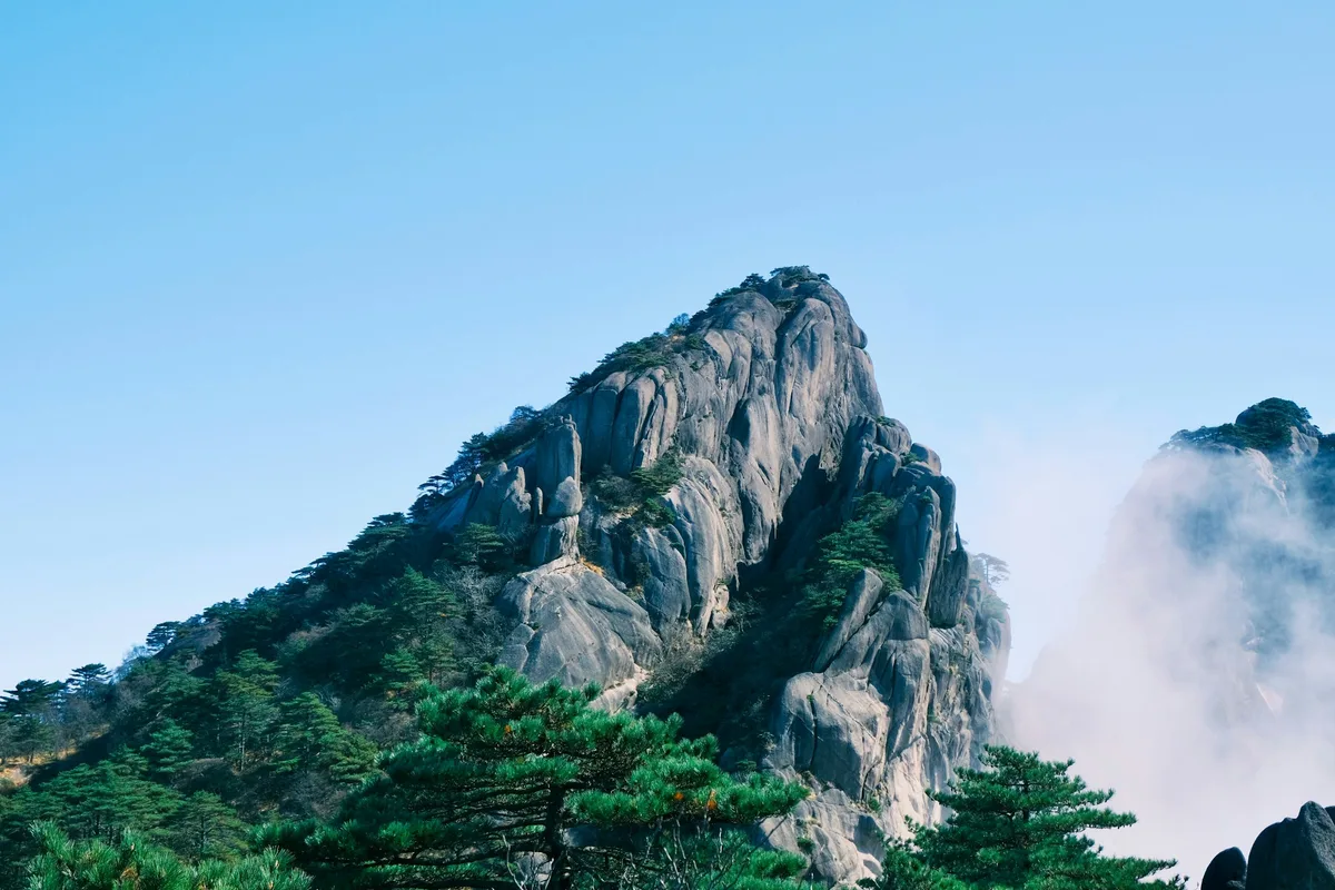
The rock tells the story. During the late Cretaceous, around 67 million years ago, a band of volcanic activity ran through what is now southeastern Korea. Andesitic and rhyolitic magmas erupted, and hot pyroclastic flows settled into thick beds of welded tuff — ash and rock fragments compressed under their own heat into a dense, hard stone. As those tuff beds cooled, vertical fractures formed, producing the columnar jointing now visible along the Juwang Valley cliffs. Geupsudae, midway up the main trail, is the standard photo stop for the columnar tuff — a 20 to 30-meter face of near-vertical hexagonal stone columns.
Water did the rest. Over tens of millions of years, streams cut down through the tuff along its fracture lines, carving the narrow steep-walled gorge that now defines the hike. Caves formed where softer ash layers eroded faster than the welded sections above them. Juwanggul, the cave the legend names, is one of these — a natural hollow in the tuff with a waterfall spilling across its mouth. The three waterfalls — Yongchu, Jeolgu, and Yongyeon — all step down along the same stream in the main gorge.
The Cheongsong Geopark designation recognizes all of this. The 24 geosites in Cheongsong include sedimentary, igneous, hydrological, paleontological, and geomorphological locations, and Juwangsan National Park contains the most dramatic concentration: tuff cliffs, columnar joints, gorges, caves, waterfalls, and the reservoir at Jusanji. On the ground this means interpretive signs explaining rock formations, educational trails designed around geological features, and a park administration that treats the geology itself as the primary conservation asset.
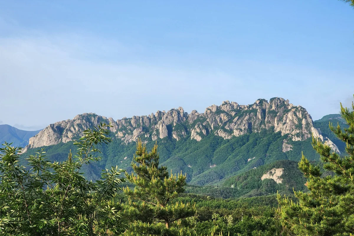
For comparison, Seoraksan has granite peaks and deeper valleys. Wolchulsan has dramatic tafoni rock but less gorge depth. Taebaeksan has cultural altars and winter snow flowers. Sobaeksan has the open alpine meadow. Juwangsan has the volcanic stone, the gorge, the caves, and the UNESCO geopark framework that ties all of it together.
Difficulty and Time Required
Juwangsan is one of the more approachable national parks in Korea for mixed-fitness groups. The lower Juwang Valley trail — from the Daejeonsa parking area past the first bridges to Yongchu Falls — is flat or gently graded, paved or stone-paved, and wheelchair-accessible for a significant stretch. Families with strollers use it regularly. The round-trip to Yongchu Falls and back is roughly 2.5 to 3 hours total.
The middle section of the main course, from Yongchu Falls up to Jeolgu Falls and on to the end of Juwang Valley, is still moderate but adds stream crossings, rockier footing, and some elevation gain. The full Juwang Valley Course — 10.6 kilometers round trip to the upper gorge — is about 4 hours 20 minutes and falls in the easy-to-moderate band.
The summit and ridge routes (Gamebong, Sirubong approach, summit via the Juwangsan main peak) are where the terrain steepens. Rock-step sections, concentrated elevation gain in the final kilometer, and exposed ridge walking make these moderate rather than easy. Most of the 300-plus meters of climbing happens in the last stretch.
The Jeolgol Valley Course is the quiet alternative. About 7 kilometers round trip, roughly 3 hours, and rated easy. Less foot traffic, slightly deeper feel, stream-side walking through denser forest. Autumn foliage season (mid-October to early November) is when Jeolgol is at its best.
Jusanji Pond is not a hike — it is a 500-meter flat walk from the parking area to the viewpoint. Allow 1 to 2 hours for photography, longer at dawn. The pond is 20 to 30 minutes by car from the Daejeonsa trailhead.
Trail Options
Juwang Valley Course — The Main Route
The iconic Juwangsan hike. From the Daejeonsa Temple parking area, the trail enters the mouth of Juwang Valley and climbs gently alongside the stream. The first 2.5 kilometers are flat to gently graded, paved or stone-paved, passing the Giamgyo and Jihagyo bridges, the Haksodae and Sirubong rock formations on the cliff walls above, and arriving at Yongchu Falls — the signature three-tier waterfall with the Seonnyeotang and Guryongso pools beneath each drop.
From Yongchu Falls the trail continues upward past Juwanggul cave and Geupsudae (the columnar jointing viewpoint), then on to Jeolgu Falls and the gorge's upper sections. The full Juwang Valley round trip is 10.6 kilometers and takes about 4 hours 20 minutes at a steady pace with photo stops.
Best for: First-time Juwangsan visitors, families (lower section), geology photography, single-day park visits, wheelchair and stroller access to Yongchu Falls.
Jeolgol Valley Course — The Quiet Alternative
From the Jeolgol Information Center on the park's eastern side, a roughly 7-kilometer round-trip trail runs along Jeolgol Stream to Daemundari (the "Great Gate Bridge") and back. Gentle gradient throughout, stream-side walking, dense forest overhead, and noticeably less foot traffic than the main Juwang route.
The autumn foliage here runs later than the main valley — peak color often holds into early November. Morning mist rising off the stream is common in October and November, and the foliage-and-mist combination is a favored setup for landscape photography. No major waterfalls, no dramatic cliff faces: this is a valley walk, not a gorge hike.
Best for: Quieter hikes, autumn foliage photography, meditative single-day walks, hikers avoiding weekend crowds.
Gamebong Peak Course — Shorter Summit Access
From the northern park entrance area, this route climbs more directly to the Gamebong ridge and summit area. Shorter than the full Juwang Valley ascent to the summit, with a different character: ridge walking, open views, less time spent in the gorge. Roughly 6 to 8 kilometers round trip depending on the exact variant, 3 to 4 hours, moderate difficulty.
From the Gamebong ridge, a connecting route can be linked back down through Juwang Valley to make a fuller loop — add 1.5 to 2 hours for the full circuit.
Best for: Time-constrained summit hikers, ridge-view photography, loops combining ridge and gorge.
Three Falls Loop — The Full Waterfall Circuit
A longer day option that connects the three named waterfalls — Yongchu, Jeolgu, and Yongyeon — plus the approach gorge and a ridge crossover. Approximately 11 kilometers, 5 to 7 hours, moderate. Best done in spring (peak water flow from snowmelt) or early summer before the rainy season clouds the afternoons.
Stream crossings are more involved at the higher points of the route. Wet-season flow can make these demanding; dry-season flow is straightforward. Waterproof footwear helps in both seasons.
Best for: Photographers pursuing all three waterfalls, fuller single-day park experiences.
Jusanji Pond — The Photography Walk
Not a hike, but the reason many people drive to Juwangsan. Jusanji Pond is a small reservoir built in 1721 during the reign of King Gyeongjong — a 100-meter-long, 50-meter-wide, 8-meter-deep irrigation dam built outside what is now the national park boundary, about 20 to 30 minutes by car from Daejeonsa.
What makes it iconic is the grove of ancient willow trees rooted directly in the water. The Korean willow variety here, 왕버들, is a species adapted to waterside and submerged growth — about 23 mature trees, more than 200 years old, with some individuals estimated at over 300 years. On a still morning with no wind and light mist, the trees reflect perfectly onto the water surface.
The pond was the primary location for Kim Ki-duk's 2003 film Spring, Summer, Fall, Winter... and Spring, which built its floating temple set on the water here. That film turned Jusanji from a regional scenic site into an internationally recognized photography destination.
From the parking area, a 500-meter flat walking trail leads to the main viewpoint on the eastern embankment. For sunrise photography, arrive 30 to 45 minutes before the official sunrise time — the best window is the half-hour of mist before the wind picks up. No entrance fee. Designated a Scenic Site in 2003.
Best for: Landscape photographers, mist-and-reflection images, cultural-film tourism, short-walk nature visits.
Best for Most Travelers
If you have one day: the Juwang Valley Course round trip — Daejeonsa, the first bridges, Yongchu Falls, Juwanggul cave, Geupsudae, Jeolgu Falls. 4 to 4.5 hours, and the full signature experience.
If you are with family or mixed fitness: Daejeonsa to Yongchu Falls and back — 5 kilometers round trip on paved trail, 2.5 to 3 hours, the main columnar cliffs and the three-tier waterfall included.
If you want quiet: the Jeolgol Valley Course — 7 kilometers, 3 hours, lower foot traffic. Best in mid-October to early November for late autumn color.
If you want the postcard: Jusanji Pond at dawn — pair it with the Juwang Valley hike on the same day. Jusanji first (6:00 AM), drive to the park (40 minutes), hike Juwang Valley (9:00 AM to 1:00 PM).
If you are not sure: start with the full Juwang Valley Course.
Who Should Do This Hike
Juwangsan suits a remarkably wide range of visitors. The lower Juwang Valley section is one of the few national park trails in Korea that is comfortably walkable with a stroller or a wheelchair as far as Yongchu Falls. Children of all ages handle the main valley hike without difficulty. Older hikers and visitors with limited mobility get a full dose of the signature cliff scenery without committing to any elevation gain.
The summit routes are moderate rather than technical — no chains, no scrambling, just stone steps and exposed upper sections — and suit hikers in reasonable fitness. An adult who can manage 500 meters of elevation gain over 5 kilometers on stone steps can handle the full summit course.
Photographers have two strong draws here. First, the volcanic geology: the columnar jointing at Geupsudae, the cliff faces throughout the gorge, Yongchu Falls, and the cave at Juwanggul all reward careful light. Second, Jusanji Pond — the willow reflections at dawn are one of the iconic Korean landscape images. Peak reflection conditions are calm, cold mornings in spring (mid-April to early May) and autumn (mid-September to early October). A 5:30 AM arrival at the pond is normal for serious landscape photographers.
Geology-minded travelers and students will get more out of Juwangsan than any other Korean national park. The interpretive signs, the Geopark framing, and the density of textbook-scale volcanic features in a single trail make it the single best introduction to Korean volcanic geology on foot.
Autumn hikers should time the main valley for mid-to-late October, and Jeolgol Valley for late October to early November. Spring hikers should come in late April to early May for stronger waterfall flow without the summer crowds.
Tips Before You Go
- The main trail is stroller-friendly to Yongchu Falls. If you have small children, older parents, or limited mobility, this is the rare national park in Korea where a partial visit is genuinely accessible.
- Jusanji Pond is outside the park. Plan the drive — 20 to 30 minutes between the pond parking and the Daejeonsa trailhead. Do not expect to walk between them.
- Jusanji sunrise requires a pre-dawn arrival. Get to the parking area 30 to 45 minutes before sunrise. Best months for perfect reflection: April–May and September–October.
- Waterfalls are most dramatic in spring. Peak flow is April to June from snowmelt. By late summer flow drops; by October it is moderate but still photogenic.
- Weekend crowds are real from mid-October through early November (fall foliage). Weekdays are far better, or start by 7:00 AM on weekends.
- Stream crossings on the higher loops can be knee-deep in the wet season (May–June) and ankle-deep the rest of the year. Waterproof boots help.
- Cell reception is generally good in the lower valley and patchy on the ridge. Emergency number is 119. Park office: 054-369-0611. Park information: 054-369-6830.
- Park entrance is free. No gate fee at any of the trailheads.
- Parking at Daejeonsa can fill on peak-season weekends by 9:00 AM. Arrive earlier or use overflow lots.
- Leeches can appear in damp areas during the June–July wet season. Salt or insect repellent helps.
- Drones are prohibited inside the national park. Photography is fine, but no aerial filming.
- Daejeonsa Temple is active. Speak quietly in temple buildings, no flash photography inside halls, respect ongoing services.
- The tuff cliffs are protected. Do not climb off-trail onto the rock faces, and do not touch or deface the columnar jointing.
How to Get There
By car (recommended): From Daegu, approximately 1 to 1.5 hours via the Jungang Expressway and local roads through Cheongsong-gun. From Seoul, approximately 3 to 3.5 hours. The park has adequate parking at Daejeonsa; Jusanji has a separate, smaller parking area.
By express bus: Seoul to Cheongsong is limited; many travelers take a bus to Andong (about 3 hours) and then a local bus or taxi to Cheongsong-gun (45 minutes to 1 hour). From Daegu, direct bus service to Cheongsong is more frequent — check Cheongsong Bus Terminal for connections to Juwangsan National Park.
By train + bus: There is no direct rail to Cheongsong. The nearest stations are at Andong (KTX-connected) and Yeongcheon. From either, connect by bus or taxi to Cheongsong.
Between Daejeonsa and Jusanji: Roughly 20 to 30 minutes by car. No practical public transport connection — expect to drive or use a taxi.
Lodging: Cheongsong-gun has a range of guesthouses and small hotels. For a Jusanji-sunrise plus Juwang-Valley-hike day, a Cheongsong-based stay is the natural choice. Day trips from Daegu are feasible but tight if the goal is a pre-dawn Jusanji start.
Use Naver Maps or Kakao Map for current road and transit information.
Final Thoughts
Juwangsan is the mountain to hike for a one-day introduction to Korean volcanic geology. The main valley trail is short enough to do well in half a day, accessible enough for mixed groups, and dense enough with features — tuff cliffs, columnar jointing, three waterfalls, a cave with a legend attached — that nothing feels skipped. The UNESCO Global Geopark designation is not decoration. The park is a working textbook of late-Cretaceous volcanism and its erosion by water.
Jusanji is the other side of the visit. A 300-year-old reservoir, 23 ancient willow trees standing in the water, a Kim Ki-duk film set that changed the location's international profile, and a 30-minute sunrise window that produces the most recognizable reflection photograph in Korean landscape photography. Pair Jusanji at dawn with the Juwang Valley in the morning and the full Juwangsan experience fits comfortably in a single day.
For the best hikes reachable directly from Seoul by subway, see the full Seoul hiking guide.
Related Guides
Explore more hiking in Korea:
- Best hikes in Seoul — full overview of Seoul's mountains by subway
- Jirisan Hiking Guide — mainland Korea's highest summit and ridge traverse
- Seoraksan Hiking Guide — Korea's most famous hiking destination
- Hallasan Hiking Guide — Jeju Island's volcanic UNESCO triple-crown summit
- Naejangsan Hiking Guide — Korea's premier autumn foliage destination
- Wolchulsan Hiking Guide — Cloud Bridge and dramatic granite
- Taebaeksan Hiking Guide — sacred mountain, winter snow flowers, ancient yew grove
- Sobaeksan Hiking Guide — royal azalea ridge and UNESCO heritage academies
FAQ
How difficult is Juwangsan? Easy to moderate. The lower Juwang Valley trail to Yongchu Falls is flat and stroller-friendly — most people handle it comfortably. The full Juwang Valley Course is 10.6 kilometers round trip and 4 hours 20 minutes at moderate pace. Summit and ridge routes add stone-step climbing and elevation gain but involve no scrambling or technical sections.
What is the UNESCO designation at Juwangsan? Cheongsong UNESCO Global Geopark, certified in May 2017 — the second UNESCO Global Geopark in Korea after Jeju. The geopark covers 845.71 square kilometers across Cheongsong County, with 24 geological sites. Juwangsan National Park is its core area: volcanic tuff cliffs, columnar jointing, gorges, caves, and waterfalls.
Where is Jusanji Pond and how do I photograph it? Jusanji is about 20 to 30 minutes by car from the Daejeonsa trailhead, outside the main park boundary. A 500-meter flat walk from the parking area leads to the main viewpoint. For the iconic willow-reflection photograph, arrive 30 to 45 minutes before sunrise on a still, cold morning — April–May and September–October are peak conditions. No entrance fee.
When is the best time to visit Juwangsan? Late September through early October for clear weather and fall foliage in the main valley (peak is mid-to-late October), or April through early May for strong waterfall flow and spring greenery. Winter is cold and often icy; summer has heavy rain and afternoon thunderstorms.
Is there an entrance fee for Juwangsan National Park? No. Entry is free at all Juwangsan trailheads and at Jusanji Pond.
How do I get to Juwangsan from Seoul or Daegu? From Daegu, about 1 to 1.5 hours by car via Cheongsong-gun. From Seoul, about 3 to 3.5 hours by car. Direct express buses from Seoul to Cheongsong are limited; most travelers go via Andong or Daegu and connect by local bus or taxi. Self-driving is the most flexible option.
Continue exploring Korea's mountains
More routes, same honest field notes.
Related guides

Nearby hikes
HardGayasan Hiking Guide: Haeinsa and Tripitaka Koreana
A practical guide to hiking Gayasan National Park — the Haeinsa Temple route to Chilbulbong, the Manmulsang scramble, and UNESCO Tripitaka Koreana woodblocks.

Same region
ModeratePalgongsan Hiking Guide: Gatbawi Buddha and Summit
A practical guide to hiking Palgongsan National Park near Daegu — the Gatbawi stone Buddha pilgrimage, Donghwasa route to Birobong summit, and how to get there.

Similar hike
EasyByeonsanbando Hiking Guide: Sea Cliffs and Naesosa
A practical guide to hiking Byeonsanbando — Korea's only peninsular national park, with Chaeseokgang UNESCO sea cliffs, Jikso Falls, and Naesosa fir forest.