Sobaeksan Hiking Guide: Royal Azaleas and Ridges
A practical guide to hiking Sobaeksan National Park — Korea's alpine meadow ridge with Birobong royal azaleas, and flanking UNESCO sites Buseoksa and Sosuseowon.

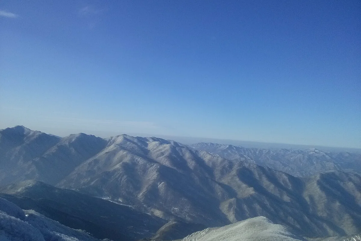
Sobaeksan is Korea's alpine meadow mountain. At 1,439 meters, Birobong is not the tallest summit in Korea — Hallasan is 510 meters taller, Jirisan's Cheonwangbong 476 meters taller — but no other mountain in the country has Sobaeksan's signature summit landscape: a long open grassland ridge, exposed to the sky on all sides, carpeted in pale-pink royal azaleas for two weeks every spring. Korean hikers describe it as a "heavenly flower garden" (천상화원). International visitors reach for Swiss Alps comparisons. What makes it distinct is the open high-elevation grassland landscape — this is the one place in Korea where a 1,400-meter summit looks like high-latitude grassland.
The mountain sits at the heart of the Baekdudaegan, the 1,400-kilometer mountain spine that runs the length of the Korean peninsula. Sobaeksan is the central hinge: peaks over 1,000 meters strung along a ridge that runs 40 kilometers north-to-south, with steep drops on either side. The ridge divides the Han River watershed to the west from the Nakdonggang to the east. In a country where most mountains present as individual peaks, Sobaeksan is a mountain of long horizons.
The flanks are what tilt the experience from a good hike into a three-day trip. Two UNESCO World Heritage sites sit at the base. Buseoksa Temple, founded in 676 AD, holds Muryangsujeon — the second-oldest wooden building in Korea, built in 1376 — and was inscribed on the World Heritage List in 2018 as part of "Sansa, Buddhist Mountain Monasteries of Korea." Sosuseowon, Korea's first royally chartered Confucian academy (1542), was added in 2019 as part of "Seowon, Korean Neo-Confucian Academies." Both sit within 15 kilometers of the main trailheads. Few hiking mountains in the world pair alpine meadow summits with two active UNESCO sites at the base.
Sobaeksan was designated Korea's 18th national park in December 1987. The park covers 322.383 square kilometers — one of the largest in the country. The royal azalea season runs roughly from May 25 to June 10. The Korean edelweiss, a native alpine species found nowhere else on mainland Asia, blooms in July and August. The Natural Monument #244 yew grove — roughly 100 trees over a thousand years old — sits on the upper ridge near Birobong. And the Sobaeksan Observatory, Korea's first modern astronomical observatory, has been running at 1,000 meters since 1974.
Quick Info
Quick summary for planning your Sobaeksan hike at a glance.
- Location: Yeongju-si / Bonghwa-gun (Gyeongsangbuk-do) and Danyang-gun (Chungcheongbuk-do)
- Highest Peak: Birobong, 1,439m
- Other Peaks: Gukmangbong (1,421m), Yeonhwabong (1,394m), Choamsan (1,350m)
- Park Area: 322.383 km² (18th National Park, December 1987)
- Mountain Range: Baekdudaegan (central spine of Korea)
- Signature Feature: Alpine meadow summit ridge with pale-pink royal azaleas (late May–early June)
- UNESCO Sites at the Base: Buseoksa Temple (2018), Sosuseowon Academy (2019)
- Difficulty: Easy–Moderate (Cheondong) to Moderate–Challenging (Samga)
- Best Time to Visit: May 25–June 10 (azalea peak), September–October (clear autumn skies)
- Entrance Fee: FREE
- Travel Time from Seoul: ~2.5–3.5h to Danyang or Yeongju, then 20–45 min to trailhead
Trail Overview
| Trail | Distance | Elevation Gain | Time | Difficulty | Best For |
|---|---|---|---|---|---|
| Cheondong Valley Course | 7km one-way | +~600m | 2–2.5h | Easy–Moderate | Most popular, first-time visitors, azalea season |
| Juknyeong Course | 7km one-way | ~+600m | 2h 40min | Easy–Moderate | Observatory tower, less crowded, ridge views |
| Huibangsa Course | 4km to Yeonhwabong; 7+km to Birobong | ~+700m | 1.5–4h | Easy–Moderate | Huibang Falls, 643 AD temple, culture day |
| Samga Valley Course | Shortest direct line to summit | ~+800m | ~2h 40min | Moderate–Challenging | Rugged terrain, experienced hikers |
| Juknyeong → Birobong Ridge | ~8.5km one-way | +~830m | 3.5h | Moderate | Full ridge traverse with azaleas |
Why Sobaeksan Is Korea's Alpine Meadow Mountain
The summit ridge is what makes Sobaeksan different. Most Korean mountains above 1,000 meters are either rocky and peaked (Seoraksan, Wolchulsan) or forested and rounded (Jirisan, Deogyusan). Sobaeksan's upper ridge — from Yeonhwabong (1,394m) through Birobong (1,439m) to Gukmangbong (1,421m) — is an open grassland plateau. Wind, shallow soil, and exposure keep trees low or absent, leaving several hectares of continuous meadow along the ridgeline. Boardwalks snake across the most sensitive sections, protecting the vegetation from foot traffic.
For two weeks each year, that meadow turns pink. The royal azalea on Sobaeksan is a distinct pale-pink variety — different from the red azaleas common on other Korean mountains — and the bloom carpets both sides of the summit ridge. Peak window is May 25 through June 10. On a clear morning in that window, the ridge is one of the most-photographed landscapes in Korea, and the weekend crowds reflect it: 500 to 1,000 visitors a day is not unusual. Weekdays are substantially quieter, and a 5:00 AM start for sunrise can put hikers on a near-empty summit.
Summer is the edelweiss season. Leontopodium coreanum — the Korean edelweiss, known locally as solnamul or waesolnari — is the same genus as the European alpine edelweiss but a distinct species found only in Korean highland zones. It blooms July through August on the upper ridge. The plants are small and easy to miss without a macro lens, but they are the signature summer alpine flower on the mountain.
The yew grove near Birobong was designated Natural Monument #244 in June 1973. Roughly 100 ancient trees, some more than a thousand years old, grow in gnarled alpine forms from wind and snow exposure. Yew (Taxus cuspidata) grows natively on only four Korean mountains — Sobaeksan, Taebaeksan, Odaesan, and Seoraksan — and the Sobaeksan grove is one of the most accessible.
For comparison, Jirisan has longer ridge traverses but denser forest. Seoraksan has more dramatic granite. Taebaeksan has deeper cultural weight. Hallasan has UNESCO designation and a volcanic summit. Sobaeksan has the open ridge, the pink-azalea carpet, the edelweiss, and two UNESCO heritage sites within driving distance of the trailhead.
Difficulty and Time Required
Sobaeksan is one of the more approachable mid-sized mountains in Korea. The main Cheondong Valley route gains roughly 600 meters over 7 kilometers on a well-maintained trail with wooden boardwalks on the sensitive upper sections. Most adult hikers in reasonable fitness can reach Birobong in 2 to 2.5 hours.
The Juknyeong Course is similar in distance and time but follows a different ridge. The terrain is slightly gentler through the forest section and provides access to the Yeonhwabong observation tower, which offers 360-degree panoramic views of the surrounding Baekdudaegan peaks.
The Huibangsa Course is the cultural route. From the trailhead it is 4 kilometers and 1.5 to 2 hours to Yeonhwabong via Huibangsa Temple and the 28-meter Huibang Falls, or 7-plus kilometers and 3 to 4 hours all the way to Birobong. The temple dates to 643 AD (Silla period) and holds the Worinseokbo, the first Korean-language Buddhist scripture.
The Samga Valley Course is the shortest direct line to the summit, at around 2 hours and 40 minutes, but the trail surface is rougher — more rock scrambling, more wooden steps on steep sections. Preferred by experienced hikers who want a more rugged approach.
Azalea-season crowding is the biggest practical challenge, not the terrain. Weekend hikers in late May and early June face congested boardwalks, limited parking, and crowded trail sections. A dawn start (5:00 AM from Cheondong) or a weekday visit makes a large difference.
Winter is a different mountain. Icy boardwalks are genuinely hazardous on the upper ridge from December through March, and traction aids (microspikes or crampons) are effectively mandatory after any snow. Huibangsa should be avoided in winter — the waterfall ice creates a serious slip hazard near the trail.
Trail Options
Cheondong Valley Course — Most Accessible, Best for First Visits
The recommended route for most hikers. From the Cheondong Information Center (near Darian Tourist Area in Danyang), the trail climbs through mixed forest along the Cheondong Valley stream for the first 3 kilometers, then transitions into alpine meadow for the final push to Birobong. Total 7 kilometers one-way, roughly 600 meters of elevation gain, 2 to 2.5 hours up.
The trail is well signposted in Korean and English, with rest benches at regular intervals. The Cheondong Rest Area at around 2.5 kilometers has water and restrooms. The upper section uses wooden boardwalks to protect alpine vegetation — stay on them. The final kilometer opens onto the summit plateau, with panoramic views in all directions on a clear day.
Access is straightforward: buses 301, 303, and 304 from Danyang city center run to Darian Tourist Area (20 to 30 minutes), and parking is available at the trailhead.
Best for: First-time Sobaeksan hikers, families with older children, azalea photography, sunrise summit attempts.
Juknyeong Course — Observatory Tower and Ridge Views
From the Juknyeong Information Center, the trail climbs through forest to Yeonhwabong (1,394m), roughly 2 hours 40 minutes one-way, 7 kilometers. Yeonhwabong holds the Sobaeksan observation tower, which provides a 360-degree view of the Baekdudaegan and is one of the best panoramic platforms on the mountain.
From Yeonhwabong, hikers can either return by the same route or continue along the ridge toward Birobong. The full Juknyeong-to-Birobong ridge traverse is around 8.5 kilometers one-way and 3.5 hours — one of the best azalea-season walks on the mountain, with pink-carpeted meadows on both sides of the path.
Crowd levels are noticeably lower than Cheondong. A good backup plan for weekend azalea hikers who want to avoid the main route congestion.
Best for: Panoramic photography, ridge traverse, hikers avoiding the Cheondong crowds, cloudy days when summit views are better from Yeonhwabong than Birobong.
Huibangsa Course — Historic Temple and 28-Meter Waterfall
The cultural route on the Yeongju side. From the Huibang Information Center, the trail climbs through forest past Huibangsa Temple (founded 643 AD), passes the 28-meter Huibang Falls, and continues to Yeonhwabong (4 kilometers, 1.5 to 2 hours) or onward to Birobong (7-plus kilometers, 3 to 4 hours total).
The temple preserves the Worinseokbo, a 15th-century Buddhist scripture printed in Korean — the first Buddhist text in the native language. Visitors should behave respectfully, speak quietly, and refrain from photography inside the temple buildings. The falls sit just above the temple and run year-round, with peak flow from May snowmelt through the summer rainy season.
Spring (May for peak waterflow) and early autumn (September for stable weather) are the best times. Avoid in winter — frozen boardwalks and ice accretion near the falls create slip hazards.
Best for: Culture-focused day hikes, family trips combining temple and waterfall, photographers interested in long-exposure water shots.
Samga Valley Course — Shortest and Most Rugged
From the Samga Campground or Samga Visitor Center, the trail runs about 2 hours 40 minutes up to Birobong — the fastest direct approach on the mountain. The surface is noticeably rougher: extensive rock steps, wooden-plank ascents, and some scrambling sections. Parking is at the Samga facilities (drivers cannot reach the Dalbatgol Village entrance directly).
Preferred by experienced hikers who want a physical challenge or a quiet trail. The valley itself has its own geological and botanical interest, and the approach delivers to the summit plateau from a different angle than the other routes.
Best for: Experienced hikers, fit day-trippers short on time, ridge-route setups combining with Cheondong descent.
Cultural Extension: Buseoksa Temple (UNESCO, 2018)
Not a hiking trail, but an essential extension for visitors with a day to spare. Buseoksa sits on the eastern base of Sobaeksan in Yeongju, 15 to 20 kilometers from the Huibangsa trailhead. The temple was founded in 676 AD by the monk Uisang, after his return from Tang China, and was inscribed on the UNESCO World Heritage List in 2018 as part of the "Sansa, Buddhist Mountain Monasteries of Korea" series.
The main draw is Muryangsujeon, the temple's main hall. Built in 1376 during the Goryeo dynasty, it is the second-oldest wooden building in Korea, and an architectural reference point for Korean traditional construction. The temple also holds five National Treasures, including the stone lantern and two Buddha images.
Allow at least 2 to 3 hours for a proper visit. Combine with a morning Huibangsa hike for a culture-and-mountain day trip.
Best for: UNESCO completionists, culture-focused travelers, photographers interested in traditional architecture.
Cultural Extension: Sosuseowon Academy (UNESCO, 2019)
Korea's first royally chartered Confucian academy, also in Yeongju. Founded in 1542 as Baegundong Seowon by the local magistrate Ju Se-bung, it was renamed Sosuseowon after receiving a royal charter from King Myeongjong at the recommendation of the Confucian scholar Yi Hwang (Toegye) — making it the first seowon formally sanctioned by the Joseon court. Inscribed on the UNESCO World Heritage List in 2019 as one of the nine academies in "Seowon, Korean Neo-Confucian Academies."
Located at 2740 Sobaek-ro, Suheung-myeon, Yeongju-si. Guided tours and an on-site museum document the history of Joseon-era Confucian education. Best paired with a Buseoksa visit on the same day — both sit within the Yeongju side of the mountain.
Best for Most Travelers
If you have one day: the Cheondong Valley route round trip — 4 to 5 hours moving, plus summit time. The standard Sobaeksan experience.
If you want azaleas: late May to early June, weekday, 5:00 AM start from Cheondong. Arrive at the summit by 7:00 to 7:30 for the best light and the smallest crowds.
If you want panoramas: Juknyeong to Yeonhwabong for the observation tower, or extend along the ridge to Birobong for the full traverse.
If you want culture: Huibangsa in the morning, Buseoksa and Sosuseowon in the afternoon. Two UNESCO sites and a hike in one day is feasible.
If you want quiet: Samga Valley or the Juknyeong → Birobong ridge during a weekday. Both routes see far less traffic than Cheondong.
If you are not sure: start with Cheondong.
Who Should Do This Hike
Sobaeksan suits a wide range of hikers. The Cheondong Valley route is one of the more forgiving summit approaches at this elevation in Korea — moderate grades, good trail surface, well-signed. Children over 8 in reasonable fitness can complete it. Older hikers often do the Juknyeong to Yeonhwabong section and turn around at the observation tower.
Photographers have one clear priority: the summit ridge with royal azaleas during the last week of May and the first week of June. This is one of the iconic Korean hiking photographs, and the bloom window is narrow. Plan around it — check the park's bloom updates before travel, and have flexibility in the schedule. Sunrise is 5:00 to 5:30 AM in that window, meaning a 2:00 to 3:00 AM start from the trailhead for a dawn summit. Headlamps and pre-scouted parking are mandatory.
Culture-interested travelers should build in time for Buseoksa and Sosuseowon. Both are active heritage sites with on-site museums, guided options, and significant architectural and textual holdings. A two-day trip (one day hiking, one day heritage) is the natural shape for a full Sobaeksan visit.
Summer visitors should factor in afternoon thunderstorms and early-morning fog through the July-August rainy season. Leech socks are worth carrying in damp vegetation. Winter visitors should treat the mountain as a technical proposition — icy boardwalks above 1,200 meters, short daylight, and cold exposure on the exposed ridge make this an advanced winter hike, not a beginner's snow walk.
Tips Before You Go
- Azalea season is crowded. Weekends from May 25 to June 10 see 500 to 1,000 visitors a day. Arrive before 6:00 AM on weekends, or visit on a weekday.
- Cheondong is the easiest route. For first-time visitors and mixed-ability groups, start here.
- Bring layers for the summit. Temperatures drop roughly 6°C per 1,000 meters of elevation — the ridge in June can feel like April weather. A windproof jacket is useful year-round.
- Wooden boardwalks are slippery when wet. Take the descent carefully after rain, and in winter never attempt the upper ridge without traction aids.
- Afternoon thunderstorms build regularly from June through August. Lightning on the open ridge is a serious risk. Start early and plan to descend by early afternoon.
- Leeches can appear in damp vegetation in late June and July. Salt, insect repellent, or leech socks help.
- Carry 2 to 3 liters of water. Reliable water sources are at the information centers; stream water should be treated or filtered.
- Cell reception is available at trailheads and generally good at Birobong, but patchy on the ridge between peaks. Do not rely solely on phone navigation.
- Park entrance is free. There are no gate fees at Sobaeksan trailheads.
- Parking is limited at Cheondong during peak season. Arrive very early or use public transport from Danyang.
- Huibangsa Temple is active. Quiet conversation, no photography inside buildings, respect monastic routines.
- The yew grove, Natural Monument #244, is protected. Do not touch, climb, or take cuttings from the ancient trees.
- UNESCO extensions need time. Budget 2 to 3 hours each for Buseoksa and Sosuseowon — a proper visit, not a drive-through.
- Emergency contact: 119 (ambulance / fire / rescue). Mountain rescue is integrated with the 119 system.
How to Get There
By express bus (from Seoul): Seoul Express Bus Terminal or Dong Seoul Terminal to Danyang (for Cheondong) or Yeongju (for Huibangsa / Juknyeong). Approximately 2.5 to 3 hours. From Danyang, take local buses 301, 303, or 304 to Darian Tourist Area (20 to 30 minutes). From Yeongju, local buses or taxi to the trailhead (15 to 35 minutes).
By train: ITX or Mugunghwa from Seoul Cheongnyangni Station to Danyang or Yeongju. Approximately 2 to 3 hours. Connect by local bus or taxi to the trailhead.
By car: Seoul to Danyang is approximately 2.5 to 3.5 hours via the Jungang Expressway. Parking is available at all main trailheads (Cheondong, Juknyeong, Huibangsa, Samga), but fills up fast during azalea season.
Between the two sides of the mountain: Danyang (western) and Yeongju (eastern) are roughly 45 minutes apart by road via the Juknyeong pass. Visitors doing multi-day trips often stay in one town and drive to trailheads on the other side.
Return transport timing: Last local buses from trailheads run around 17:00–18:00. Build return timing into the hike — a delayed descent means a taxi or an overnight stay in Danyang or Yeongju.
Use Naver Maps or Kakao Map for real-time transit on the day.
Final Thoughts
Sobaeksan is the mountain to hike if you want Korea's best open-ridge landscape. Two weeks of the year, the summit plateau carpets itself in pale-pink azaleas and becomes one of the most photographed landscapes in the country. The other fifty weeks, the ridge is still the best long alpine walk on the mainland — exposed grassland at 1,400 meters, boardwalks over fragile meadow, yew trees that have been standing for a thousand years.
The UNESCO sites at the base change the shape of the visit. Buseoksa's Muryangsujeon has been standing since 1376. Sosuseowon has been at its site since 1542. Both are within driving distance of the trailheads, and both reward a proper afternoon. Pair them with a morning hike and Sobaeksan becomes a mountain and a heritage day in a single trip.
Come for the azaleas if you can. Come in autumn if you can't. Either way, the summit plateau is unlike anything else in Korean hiking.
For the best hikes reachable directly from Seoul by subway, see the full Seoul hiking guide.
Related Guides
Explore more hiking in Korea:
- Best hikes in Seoul — full overview of Seoul's mountains by subway
- Jirisan Hiking Guide — mainland Korea's highest summit and ridge traverse
- Seoraksan Hiking Guide — Korea's most famous hiking destination
- Hallasan Hiking Guide — Jeju Island's volcanic UNESCO triple-crown summit
- Naejangsan Hiking Guide — Korea's premier autumn foliage destination
- Wolchulsan Hiking Guide — Cloud Bridge and dramatic granite
- Taebaeksan Hiking Guide — sacred mountain, winter snow flowers, ancient yew grove
FAQ
When is the best time to hike Sobaeksan? Late May through early June — roughly May 25 to June 10 — for the royal azalea peak bloom on the summit ridge. This is Sobaeksan's signature landscape. September and October are the second-best window: stable weather, clear skies, comfortable temperatures, and far fewer visitors than during azalea season.
How difficult is Sobaeksan? Easy to moderate on the Cheondong Valley route — the recommended first-time approach. 7 kilometers one-way, roughly 600 meters of elevation gain, 2 to 2.5 hours up on a well-maintained trail with wooden boardwalks on the upper section. Most adult hikers in reasonable fitness can complete it. The Samga Valley route is more rugged and better suited to experienced hikers.
Is there an entrance fee for Sobaeksan National Park? No. Entry to Sobaeksan is free — there are no gate fees at any of the trailheads. Parking is available at each trailhead but fills quickly during azalea season.
What are the UNESCO sites at Sobaeksan? Two. Buseoksa Temple, founded in 676 AD, was inscribed in 2018 and holds the 1376 Muryangsujeon — the second-oldest wooden building in Korea. Sosuseowon, founded in 1542 as Korea's first royally chartered Confucian academy, was inscribed in 2019 as part of "Seowon, Korean Neo-Confucian Academies." Both sit within 15 to 20 kilometers of the Huibangsa trailhead on the Yeongju side.
How do I get to Sobaeksan from Seoul? Express bus or train from Seoul to Danyang (for Cheondong) or Yeongju (for Huibangsa / Juknyeong / Buseoksa / Sosuseowon). Approximately 2.5 to 3 hours. From either town, local buses or taxi to the trailhead take 15 to 45 minutes. Driving from Seoul takes 2.5 to 3.5 hours via the Jungang Expressway.
Can I hike Sobaeksan in winter? Yes, but treat it as a technical winter hike. The wooden boardwalks above 1,200 meters are genuinely dangerous when iced, and traction aids (microspikes or crampons) are essential after any snow. Daylight is short, and cold exposure on the exposed summit ridge is significant. Avoid the Huibangsa route in winter — the falls and nearby trail create a slip hazard.
Continue exploring Korea's mountains
More routes, same honest field notes.
Related guides

Same region
ModerateSongnisan Hiking Guide: Beopjusa and Munjangdae
A practical guide to hiking Songnisan National Park — the Cheonhwangbong summit loop, UNESCO-listed Beopjusa Temple, the 33m Bronze Buddha, and Seoul access.

Similar hike
HardGayasan Hiking Guide: Haeinsa and Tripitaka Koreana
A practical guide to hiking Gayasan National Park — the Haeinsa Temple route to Chilbulbong, the Manmulsang scramble, and UNESCO Tripitaka Koreana woodblocks.

Same region
ModerateGyeryongsan Hiking Guide: Temple Traverse and Ridge
A practical guide to hiking Gyeryongsan National Park near Daejeon — the Donghaksa-Gapsa temple traverse, Nammae Twin Towers, autumn foliage, and Seoul access.