Taebaeksan Hiking Guide: Cheonjedan Altar and Snow
A practical guide to hiking Taebaeksan National Park — Korea's sacred mountain with the Cheonjedan heaven altar, winter snow flowers, and yew grove trails.

Taebaeksan is Korea's spiritual mountain. At 1,567 meters, Janggunbong is not the country's highest summit — Hallasan is 380 meters taller, Jirisan's Cheonwangbong 350 meters taller — but Taebaeksan holds a cultural position none of them can match. According to the Dangun foundation myth, this is where Hwan'ung descended from the heavens with 3,000 followers and established Sinsi, leading to the founding of Gojoseon — the first Korean kingdom — in 2333 BC. The mountain has been a site of state-level heaven-veneration rituals since at least the Silla period, and those rituals continue today.
The physical center of that heritage is the Cheonjedan — a complex of three natural-stone altars at 1,500 meters, used for the cheonje heaven ceremony. The main altar, Cheonwangdan, is an oval stone structure 27.5 meters in circumference and 3 meters tall, built of uncut stones stacked without mortar. On New Year's Day, the October Taebaek Festival, and Gaecheonjeol (October 3), the altar hosts formal ceremonies that draw thousands.
The mountain is also hydrologically central. The Han River — which flows through Seoul — originates from Geomryongso on Taebaeksan's western slopes. The Nakdonggang, Korea's longest river, originates from Hwangji Pond in downtown Taebaek City. Two of Korea's three major river systems begin here, and the name "Taebaek" — often glossed as "Great White" — refers to the snow-covered peaks that feed both.
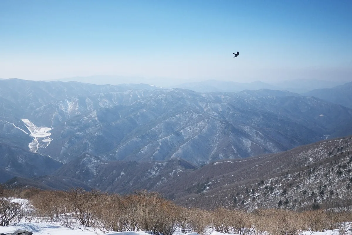
Taebaeksan was designated Korea's 22nd national park in August 2016 — the most recent addition to the system. Above 1,400 meters, the ridge holds the largest yew grove in Korea: trees averaging over 1,000 years old, gnarled into alpine shapes by wind and snow. In winter, ice accretion turns those yews into the "snow flower" scenery that Korean hikers travel here specifically to see.
Quick Info
Quick summary for planning your Taebaeksan hike at a glance.
- Location: Taebaek-si, Gangwon-do, South Korea
- Highest Peak: Janggunbong, 1,567m
- Other Peaks: Yeongbong (1,560m), Munsubong (1,531m)
- Park Area: 70.052 km²
- Mountain Range: Baekdudaegan (central spine of Korea)
- Park Designation: 22nd National Park (August 2016)
- River Sources: Han River (Geomryongso), Nakdonggang (Hwangji Pond)
- Difficulty: Advanced (most routes)
- Best Time to Visit: January–February (snow flowers), May–June (wildflowers), September–October (clear skies)
- Entrance Fee: ~₩3,000
- Signature Feature: Cheonjedan heaven altar (1,500m) + ancient yew grove
- Travel Time from Seoul: ~3.5–4h by train to Taebaek Station + 20–30 min to trailhead
Trail Overview
| Trail | Distance | Elevation Gain | Time | Difficulty | Best For |
|---|---|---|---|---|---|
| Yuilsa Route (Green) | 8.5km round trip | +681m | 4–4.5h | Advanced | Most popular, well-maintained |
| Danggol Route | 4.4km to altar | +~650m | 2.5h one-way | Advanced | Cable car descent option |
| Baekdansa Route (Blue) | similar to Yuilsa | ~+700m | 4–5h | Intermediate–Advanced | Quieter, photography |
| Baekdansa ↔ Yuilsa Loop | ~15km | +800m cumulative | 6–7h | Hard | Experienced hikers, full ridge |
| Taebaek → Hambaek Extension | 12–15km | varies | 7–9h | Very Advanced | Baekdudaegan ridge walking |
Why Taebaeksan Is Korea's Sacred Mountain
Taebaeksan has been treated as sacred for as long as Korea has been keeping records. The Samguksagi — the 12th-century history of the Three Kingdoms — documents Silla royalty conducting heaven-veneration rituals here. The Goryeo and Joseon dynasties continued the practice, and the Cheonjedan has stood at 1,500 meters through all of that. It is the oldest continuously active religious site on a Korean mountain.
The Dangun foundation myth roots the mountain deeper still. According to the Samguk Yusa, Hwan'ung — son of the sky god Hwanin — descended to Taebaeksan with 3,000 followers and established Sinsi, "the divine city." His union with a woman who had previously been a bear produced Dangun Wanggeom, the founder of Gojoseon in 2333 BC. Whatever one makes of the mythology, the story has anchored Korean identity for over a thousand years, and Taebaeksan is where it is set.
Three altars make up the Cheonjedan complex: Cheonwangdan in the center (the main altar), Janggundan to the north, and Hadan to the south. The main altar is a 3-meter-high oval of uncut stones, 27.5 meters around, built without mortar. Ceremonies continue year-round, with the largest on New Year's Day (at dawn, facing the east coast sunrise), during the October Taebaek Festival, and on Gaecheonjeol (October 3) commemorating the legendary founding.
The ancient yew grove on the upper ridge is the mountain's other distinctive feature. These are Taxus cuspidata, trees averaging more than 1,000 years in age, growing in a band roughly between 1,400 and 1,567 meters. In winter, wind-driven moisture freezes onto their branches, forming the ice accretions Korean hikers call "snow flowers" (설화). The Yuilsa trail passes directly through the grove, and the sight of 1,000-year-old yews covered in rime at sunrise is the single most photographed winter hiking scene in Korea.
For comparison, Hallasan has higher elevation and UNESCO designations. Jirisan has deeper valleys and older temples. Seoraksan has more dramatic granite. Wolchulsan has more technical rock. Taebaeksan has the cultural weight — the foundation myth, the active altar, the millennium-old yews, the headwaters of two major rivers — and the winter landscape that nothing else in Korea replicates.
Difficulty and Time Required
Taebaeksan is rated advanced across all main routes, but the difficulty comes from sustained uphill and elevation — not from technical scrambling. There are no chain sections or rope-assisted scrambles like Wolchulsan. What there is instead: 680 meters of elevation gain across 4 kilometers of mostly stone-step trail, cold exposure above 1,400 meters, and wind on the summit ridge.
The Yuilsa route is the standard option. 8.5 kilometers round trip, 681 meters of elevation gain, 4 to 4.5 hours. The trail is well-maintained with stone steps and numbered markers, and most adult hikers in reasonable fitness can complete it. Descent via the same route takes 2 to 2.5 hours.
The Danggol route is steeper and shorter — 4.4 kilometers to the Cheonjedan, around 2.5 hours up. The main advantage is the cable car at Danggol Plaza, which makes a "hike up, ride down" option feasible.
The Baekdansa route is a quieter parallel to Yuilsa with similar distance and slightly gentler terrain. Combined with Yuilsa it forms a 15-kilometer loop — a 6 to 7-hour full-day hike for fit hikers.
The Hambaek extension is a multi-peak ridge traverse for experienced long-day hikers. 12 to 15 kilometers, 7 to 9 hours, and daylight-limited in winter.
Winter changes everything. Ice on stone steps, wind chill on the ridge, and the narrow daylight window mean microspikes or crampons are effectively mandatory between December and early April. Start before dawn for a winter summit; the 5 to 6-hour daylight window is tight.
Trail Options
Yuilsa Route — Most Popular and Best Maintained
The standard Taebaeksan hike. From the Yuilsa Information Center at roughly 661 meters, the trail climbs through Yuilsa Temple, past the Danggol Shelter, up through the yew grove to Cheonjedan (1,500 meters), and then a short final push to Janggunbong summit (1,567 meters). Total 8.5 kilometers round trip, 681 meters of elevation gain, 4 to 4.5 hours.
The trail is well-signed with numbered posts, has multiple rest benches, and is stone-paved on the steepest sections. Views start improving noticeably above 1,400 meters, and the yew grove on the upper section is the main scenic payoff.
In winter (December through early April), the trail holds snow and ice. Microspikes are effectively mandatory; full crampons are safer on icy days. The snow flowers on the yew grove peak in January and February.
Best for: Most visitors, first-time Taebaeksan hikers, winter snow-flower photography, year-round access.
Danggol Route — Shorter, Steeper, Cable Car Option
From Danggol Plaza (the main visitor hub, with restaurants, restrooms, and the cable car station), a 4.4-kilometer trail climbs more steeply to Cheonjedan in around 2.5 hours. The route passes through a denser forest section before opening onto the altar ridge.
The cable car at Danggol makes this the best "hike up, ride down" option — ascend by trail, descend by cable car for tired legs or short daylight. This is also the starting point for the annual Snow Festival (mid-January), when the plaza fills with snow sculptures and evening illumination.
Best for: Hikers short on time, cable-car-descent combos, winter festival visits.
Baekdansa Route — Quieter Alternative
From the Baekdansa Temple entrance, a similar-length trail to Yuilsa climbs through quieter forest to the ridge. Less foot traffic, less infrastructure, and a more natural trail surface. Better for photography, wildflower observation, and hikers who prefer solitude to facilities.
Combined with Yuilsa as a traverse (Baekdansa → summit → Yuilsa or vice versa), the full loop is approximately 15 kilometers and takes 6 to 7 hours. This is the recommended route for experienced hikers who want the whole mountain in one day.
Best for: Photographers, hikers avoiding crowds, full-ridge traversers.
Taebaek ↔ Hambaek Multi-Peak Extension
Hambaeksan (1,573 meters) sits immediately west of Taebaeksan and is actually slightly higher. A connecting ridge route covers 12 to 15 kilometers across both peaks with Baekdudaegan ridge walking, 7 to 9 hours, very advanced difficulty. Requires strong fitness, settled weather, and full daylight — winter attempts are not recommended unless experienced.
Best for: Experienced ridge hikers, Baekdudaegan completionists, multi-peak days.
Geumdaebong–Daedeoksan Wildflower Zone
North of the main park, the Geumdaebong–Daedeoksan area is recognized as the largest alpine wildflower habitat in Korea. Peak bloom is May through June, featuring the Taebaek violet (endemic), Gumgang violet, twin wind flowers, and alpine lilies. Full-day hike, intermediate-to-advanced difficulty.
This is the alternative spring destination on the mountain — different from the main summit loop but centered on the same massif.
Best for: Wildflower enthusiasts, spring hikers, photographers with macro lenses.
Cultural Stop: Cheonjedan Heaven Altar
Not a trail, but the cultural heart of every Taebaeksan hike. The Cheonjedan sits at 1,500 meters on the Yuilsa route and consists of three altars: Cheonwangdan (the main oval-shaped natural-stone altar, 27.5 meters around and 3 meters high), Janggundan to the north, and Hadan to the south.
Ceremonies happen year-round. Dawn on January 1 is the largest — hundreds of visitors make the overnight climb for the first sunrise of the year. The October Taebaek Festival and Gaecheonjeol (October 3) are the other major dates. On ordinary days the altar is quiet, and the combination of stone, wind, and open sky makes it one of the most atmospheric high points in Korean hiking.
Best for Most Travelers
If you have one day: the Yuilsa round trip — the yew grove, Cheonjedan, the summit, and back. 4 to 4.5 hours. The standard Taebaeksan experience.
If you want winter: the Yuilsa route in January or February — arrive before dawn for the snow flowers on the yew grove. Wear microspikes. This is the winter hike in Korea.
If you want the full mountain: the Baekdansa → Yuilsa loop — around 15 kilometers, 6 to 7 hours, the whole ridge in one day for fit hikers.
If you want shorter: Danggol up, cable car down — 2.5 hours to the altar, cable car return.
If you are not sure: start with Yuilsa.
Who Should Do This Hike
Taebaeksan suits hikers in moderate-to-good fitness who can manage a sustained 680-meter climb across 4 kilometers. No technical skills are required — this is stone-step and ridge-walking terrain, not scrambling. Children over 10 in good fitness can complete the Yuilsa route; elderly hikers often use the Danggol route with cable car descent.
Winter is the standout season and also the most demanding. The snow flower display on the yew grove from mid-December through late February is a genuinely world-class winter landscape, but the combination of subfreezing temperatures, wind chill, and icy stone steps makes microspikes mandatory and crampons safer on the worst days. Cold weather gear — insulated jacket, hat, gloves, face covering — is not optional above 1,400 meters in winter.
Photographers should plan around winter sunrise at Cheonjedan (arrive 45 minutes early in the dark) or autumn panoramas from the summit in October. The snow festival in mid-January is a separate draw — night photography in Danggol Plaza with illuminated snow sculptures.
History-minded visitors and anyone interested in Korean religious tradition should time their visit for one of the major Cheonjedan ceremony days: New Year's Day dawn, the October Taebaek Festival, or Gaecheonjeol on October 3.
Tips Before You Go
- Winter requires microspikes or crampons. From December through early April, ice on stone steps is standard. Do not rely on hiking boots alone.
- Start early in winter. Daylight is 5 to 6 hours. A dawn summit requires a 5am or earlier departure from the trailhead.
- Wind chill is serious above 1,400 meters. Summit temperatures in January can be -15°C to -20°C with 20 to 40 km/h winds. Wear a proper winter jacket, hat, gloves, and face covering.
- Summer thunderstorms build in the afternoon from June through August. Start early and plan to descend by early afternoon. Lightning on the exposed ridge is a real risk.
- Carry 2 to 3 liters of water — more in summer. Reliable water sources are at Danggol Plaza and Yuilsa Information Center; the trail has limited water above 1,200 meters.
- Cell reception is limited on the ridge. Leave an itinerary with someone off-mountain. Emergency number is 119.
- Park entrance is around ₩3,000. Payment at the gates, cash or card.
- Cable car at Danggol is the recommended descent for tired legs, snow-festival visitors, or short winter days.
- Cheonjedan is an active religious site. Be quiet near the altars, do not place offerings unless participating in a formal ceremony, and do not stand on the altar stones.
- Yew grove is protected. Stay on the marked trail; do not touch trunks or climb the trees. These are 1,000-year-old natural monuments.
- Emergency contacts: 119 (ambulance/fire/rescue), 112 (police), Danggol Ranger Station +82-33-550-5631.
How to Get There
By train (from Seoul): KTX or Mugunghwa from Seoul Station to Taebaek Station — approximately 3.5 to 4 hours. From Taebaek Station, taxi or local bus to the trailhead: Yuilsa is about 15 kilometers (30 minutes), Danggol is about 10 kilometers (20 minutes).
By express bus: Seoul Central City Terminal or Dong Seoul Terminal to Taebaek Bus Terminal, approximately 3 to 4 hours. Local taxi or bus to the trailhead from there.
By car: Seoul to Taebaek is approximately 4 to 5 hours via the Yeongdong Expressway. Parking is available at both Yuilsa and Danggol trailheads.
From Gangneung or the East Coast: Regular bus service from Gangneung to Taebaek (2.5 to 3 hours), or drive via coastal and inland routes.
Snow festival season (mid-January): Accommodation in Taebaek books out early. Reserve 1 to 2 months in advance. The Danggol Plaza area and the Cheonjedan New Year's sunrise in particular draw large crowds.
Use Naver Maps for real-time transit on the day.
Final Thoughts
Taebaeksan is the mountain at the center of the Korean national story. Hwan'ung descended here. Dangun was born here. Silla kings held heaven ceremonies here, and the stone altar that holds those ceremonies is still in use. The Han and the Nakdonggang — the two rivers that built the peninsula's civilizations — both start on its slopes. And above 1,400 meters, a grove of 1,000-year-old yew trees stands as the oldest living witness to all of it.
The Yuilsa route delivers the whole experience in under five hours. The winter snow flowers on the yew grove are a landscape no other Korean mountain offers. The Cheonjedan at dawn, with the wind moving across the altar stones and the first light coming up over the East Sea, is as close as Korean hiking comes to the foundation of the culture.
For the best hikes reachable directly from Seoul by subway, see the full Seoul hiking guide.
Related Guides
Explore more hiking in Korea:
- Best hikes in Seoul — full overview of Seoul's mountains by subway
- Jirisan Hiking Guide — mainland Korea's highest summit and ridge traverse
- Seoraksan Hiking Guide — Korea's most famous hiking destination
- Hallasan Hiking Guide — Jeju Island's volcanic UNESCO triple-crown summit
- Naejangsan Hiking Guide — Korea's premier autumn foliage destination
- Wolchulsan Hiking Guide — Cloud Bridge and dramatic granite
FAQ
How difficult is Taebaeksan? Advanced in difficulty rating but non-technical. The Yuilsa route gains 681 meters over 4 kilometers on well-maintained stone steps. There is no scrambling or chain-assisted climbing. Most adult hikers in reasonable fitness can complete it in 4 to 4.5 hours. Winter adds ice and cold-weather demands that require microspikes and proper insulation.
When are the snow flowers at their peak? Mid-December through late February. The combination of cold temperatures, wind-driven moisture, and the yew grove's exposed position above 1,400 meters creates the ice-accretion "snow flowers" that make the mountain famous in winter. January and February are the most reliable window.
What is the Cheonjedan and can I visit it? The Cheonjedan is a stone heaven altar at 1,500 meters on Taebaeksan, in continuous use since at least the Silla period. Yes, all hikers pass through or near the altars — they are on the main Yuilsa trail. The altars are active religious sites, so be respectful: do not stand on the stones, do not leave offerings, and observe quietly.
Can I hike Taebaeksan in winter as a beginner? Not recommended as a first winter hike. The trail itself is non-technical but the combination of subfreezing temperatures, wind chill above 1,400 meters, ice on stone steps, and short daylight make it demanding. Start with the Yuilsa route with microspikes, start before dawn, and go with someone experienced if possible.
How do I get to Taebaeksan from Seoul? Train from Seoul Station to Taebaek Station takes approximately 3.5 to 4 hours, followed by a 20 to 30-minute taxi or bus to the trailhead. Driving takes around 4 to 5 hours via the Yeongdong Expressway. Express buses from Seoul terminals are another option.
Is Taebaeksan worth visiting? Yes. It is the cultural center of Korean mountain tradition — the site of the Dangun foundation myth, the Cheonjedan heaven altar, the source of the Han and Nakdong rivers, and Korea's largest yew grove. The winter snow flower landscape is genuinely unique in Korea. It is the most recent addition to the national park system (2016) and an essential stop for hikers interested in Korean history and culture.
Continue exploring Korea's mountains
More routes, same honest field notes.
Related guides

Nearby hikes
HardChiaksan Hiking Guide: Birobong and Guryongsa Trail
A practical guide to hiking Chiaksan National Park near Wonju — the Guryongsa route to Birobong summit at 1,288m, Ladder Ridge scrambling, and Seoul access.

Nearby hikes
ModerateOdaesan Hiking Guide: Fir Forest and Birobong
A practical guide to hiking Odaesan National Park in Pyeongchang — the Birobong summit at 1,563m, Woljeongsa fir forest, Sogeumgang Gorge, and Seoul access.

Nearby hikes
HardSeoraksan Hiking Guide: Ulsanbawi and Daecheongbong
A practical guide to hiking Seoraksan National Park — Ulsanbawi, Daecheongbong summit at 1,708m, Dinosaur Ridge, Biryong Waterfall, and bus access from Seoul.