Byeonsanbando Hiking Guide: Sea Cliffs and Naesosa
A practical guide to hiking Byeonsanbando — Korea's only peninsular national park, with Chaeseokgang UNESCO sea cliffs, Jikso Falls, and Naesosa fir forest.

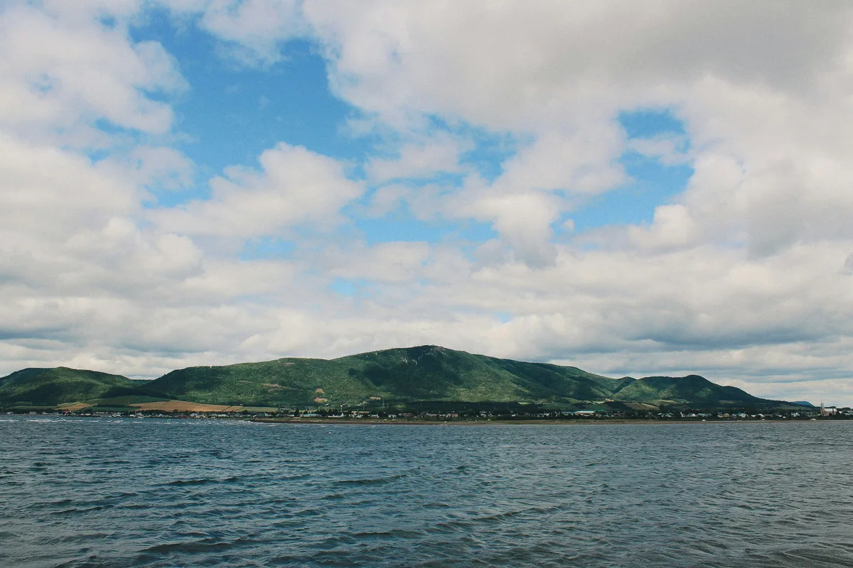
Byeonsanbando is Korea's only peninsula national park. Every other park in the system is either inland (Jirisan, Seoraksan, Taebaeksan) or island-based (Hallasan on Jeju, Dadohaehaesang in the southern archipelago). Byeonsanbando is the one that works both ways at once: a 508-meter mountain massif, a thousand-year-old Buddhist temple, a 30-meter waterfall inside a named nine-scenic-spot valley, and 3.5 kilometers of layered sedimentary sea cliffs — all inside a single 153.934-square-kilometer park in Buan County, North Jeolla Province. The administrative split tells the story directly: Inner Byeonsan (내변산) is the mountain side, Outer Byeonsan (외변산) is the coast.
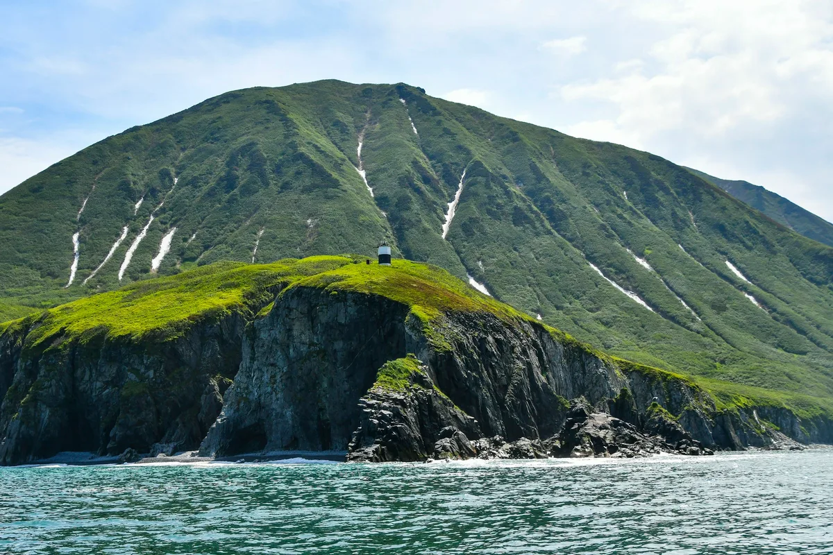
The coastal side is the one international travelers hear about first. Chaeseokgang — literally "Colorful Stone River" — is a 1.5-kilometer run of sea cliffs beside Gyeokpo Port, exposed at low tide, showing stacks of sedimentary layers pressed horizontally like the pages of a book. The rock is late-Cretaceous, around 70 million years old, formed when this area was a freshwater lake basin. Purple conglomerate, yellow sandstone, and dark mudstone beds repeat up the cliff face. Next to Chaeseokgang runs Jeokbyeokgang — "Red Cliff River" — a 2-kilometer stretch of iron-oxide-stained red sea cliff. Both were designated a unified Scenic Site in 2004, and in 2023 the area was inscribed as part of the Jeonbuk West Coast UNESCO Global Geopark.
The mountain side is quieter but older. Naesosa Temple was founded in 633 AD during the Baekje dynasty and has been in continuous use for nearly 1,400 years. Its most famous feature is not a building but a 600-meter walk of fir trees from the Iljumun gate to the Cheonwangmun — a dense canopy of 400 to 500-year-old fir trees recognized as one of Korea's three great fir forests, alongside Woljeongsa on Odaesan and the Gwangneung National Arboretum. The Daeungbojeon main hall holds the temple's other signature feature: Joseon-era carved wooden flower-lattice doors (꽃살문) cut in repeating lotus and chrysanthemum patterns, left unpainted so the woodgrain remains visible.
Byeonsanbando was designated Korea's 19th national park in June 1988. It covers 153.934 square kilometers — 89 percent land and 11 percent marine. Uisanbong at 508 meters is the highest point, and Gwaneumbong is the main trail summit. Nine named water features — Bongnaegugok, the "Nine Scenics of Bongnae" — step up the main valley from Daeso pool through the 30-meter Jikso Falls to Amji at the top. A full visit wants two days: one in the mountains, one on the coast.
Quick Info
Quick summary for planning your Byeonsanbando hike at a glance.
- Location: Buan-gun, Jeollabuk-do (North Jeolla Province)
- Highest Peak: Uisanbong, 508m
- Main Trail Peak: Gwaneumbong (on Inner Byeonsan loops)
- Park Area: 153.934 km² (89% land, 11% marine)
- Park Designation: 19th National Park (June 1988)
- UNESCO Status: Jeonbuk West Coast UNESCO Global Geopark (which includes Byeonsanbando) (2023)
- Uniqueness: Korea's only peninsula national park (mountains + coast in one park)
- Signature Features: Naesosa temple and fir forest, Chaeseokgang sea cliffs, Jikso Falls, Bongnaegugok nine-scenics
- Difficulty: Easy (Jikso Falls, fir forest, coastal walk) to Moderate (Gwaneumbong–Sebong loop)
- Best Time to Visit: September–October (stable weather), April–May (waterfalls and fresh greenery)
- Entrance Fee: FREE
- Travel Time from Seoul: ~3–3.5h by car; ~3–4h by express bus
Trail Overview
| Trail | Distance | Elevation Gain | Time | Difficulty | Best For |
|---|---|---|---|---|---|
| Jikso Falls Trail | 4.6km round trip | +~150m | ~2h | Easy–Moderate | Waterfall, summer, families |
| Naesosa Fir Forest Walk | 600m one-way | Minimal | 30–60min | Very Easy | Temple access, all ages, photography |
| Gwaneumbong–Sebong Loop | ~8–10km | +~400m | 4–5h | Moderate | Full mountain traverse, ridge and temple |
| Chaeseokgang Coastal Walk | ~2km | Minimal | 1–2h | Easy (tide-dependent) | Sunset, sea cliffs, geopark |
| 2-Day Combined Itinerary | — | — | 2 days | Mixed | Full mountain + coastal experience |
Why Byeonsanbando Is Korea's Only Peninsula National Park
The designation is literal. Of Korea's 22 national parks, every single one other than Byeonsanbando is categorized as a mountain park, a coastal/marine park, or a historic park. Only Byeonsanbando combines a mountain interior and a coastal exterior under a single boundary, with the hinge point being the reason it works: the peninsula juts into the Yellow Sea roughly 20 kilometers east-west and 13 kilometers north-south, compressing a full inland-coastal transect into a park the size of a single medium national park.
The Inner Byeonsan is a cluster of mid-sized peaks — Uisanbong (508m), Gwaneumbong (primary trail summit), and several neighboring summits — draining into a network of streams that feed Bongnaegugok, the "Nine Scenics of Bongnae." The nine are numbered points along a 2-kilometer section of stream: Daeso (first pool), Jikso Falls (the 30-meter drop at scenic #2), Bunokdam (splashed-jade pool), Seonnyeotang (fairy pool), Bongnaegok (main Bongnae valley), Yeongji (spirit pond), Geumgangso (Geumgang pool), Baekcheon (white spring), and Amji (rock pond). The Jikso Falls trail covers the first few scenics comfortably in 2 hours round trip.
The Outer Byeonsan is a geologically separate story. Chaeseokgang is late-Cretaceous sedimentary rock — lake-bed strata from when this area was a freshwater basin roughly 70 million years ago. The layering is textbook: alternating conglomerate (purple, from gravel), sandstone (yellow), and mudstone (dark gray to black), pressed and exposed in a 1.5-kilometer cliff face. The name "Chaeseokgang" means "colorful stone river" because the color bands read like layers across the rock. Adjacent Jeokbyeokgang — 2 kilometers of iron-oxide-stained red cliff — completes the coast-side geology.
The Jeonbuk West Coast UNESCO Global Geopark designation (2023) covers the northwestern part of the peninsula coast, including Chaeseokgang, Jeokbyeokgang, Soljaeseom (an islet), Mohang beach, Jikso Falls on the mountain side, and Wido Island offshore. This puts Byeonsanbando in the same category as the Cheongsong/Juwangsan geopark: internationally certified geological heritage alongside active hiking infrastructure.
For comparison, Jirisan is the deep interior. Seoraksan is the granite ridge. Taebaeksan is the cultural altar. Hallasan is the volcanic island. Juwangsan is the volcanic gorge. Byeonsanbando is the only one where a single park visit can include a temple-and-waterfall mountain morning and a sunset-cliff coastal evening.
Difficulty and Time Required
Byeonsanbando is one of the easier national parks in Korea across most of its trails. The elevation ceiling is 508 meters — less than half the height of Jirisan or Seoraksan — and the main trailheads start at relatively low elevations, so the total climb on any given route is moderate.
The Jikso Falls Trail is the most popular easy hike. From the Naebyeongsan Visitor Center, roughly 2.3 kilometers one-way along Byeonsan stream on a mix of dirt path and wooden steps, about 150 meters of gain, 2 hours round trip. The full Bongnaegugok can be walked more extensively by continuing beyond the falls, but most visitors turn around there.
The Naesosa Fir Forest is not a hike — it is a 600-meter flat walk between the Iljumun gate and the Cheonwangmun, passing through 400 to 500-year-old fir trees. Anyone can do it. Most visitors take 30 minutes going in, longer coming out for photos, and spend another hour or two inside the temple grounds.
The Gwaneumbong–Sebong Loop is the main Inner Byeonsan hike. From the Naeso Information Center, through the fir forest, up to Gwaneumbong, along the ridge to Sebong Samgeori and Sebong peak, and down via the Jijangam route back to the start. Approximately 8 to 10 kilometers, 4 to 5 hours, rated moderate. Steeper sections have handrails and rope-assisted segments; nothing technical, but solid footing is required.
The Chaeseokgang coastal walk is an entirely different proposition. Tide timing is everything. The cliff base is only accessible at low tide — roughly a 4 to 6-hour window per tidal cycle, twice daily. Attempting the walk at high tide is dangerous and in places impossible. Check tide charts before the day, plan to arrive 90 minutes before low tide, and leave at least 30 minutes before the tide turns. Beyond the tide, the walk itself is easy: 2 kilometers of beach and rock scrambling, minimal elevation.
A reasonable mixed pace for a fit hiker is: Day 1 — Jikso Falls morning, Naesosa fir forest and temple midday, Gwaneumbong–Sebong afternoon. Day 2 — Chaeseokgang low tide walk, timed to end near sunset for the signature light on the cliffs.
Trail Options
Jikso Falls Trail — Inner Byeonsan's Easy Waterfall Hike
From the Naebyeongsan Visitor Center, the trail climbs gently along the Byeonsan stream for 2.3 kilometers to Jikso Falls — the second of the nine Bongnaegugok scenics. 30 meters of vertical drop into a round pool, with the name Jikso ("straight pool") describing exactly that: water falls straight into a pool beneath. Roughly 150 meters of elevation gain, 2 hours round trip at a relaxed pace with photo stops.
Peak waterfall flow runs May through July — late spring snowmelt plus early summer rains. Winter access is possible but sections can ice over. Summer rains can briefly close the trail for safety; check at the visitor center before setting out.
Bongnaegugok's other named scenics — Bunokdam, Seonnyeotang, Geumgangso, and others — sit both below and above Jikso Falls. Extending the walk past the falls toward the upper scenics adds 1 to 2 hours and is worth doing in dry season.
Best for: First-time visitors, families with older children, waterfall photography, warm-weather hikes needing shade and water features.
Naesosa Fir Forest Walk — The 600-Meter Approach
From the Naeso Information Center, the approach to Naesosa Temple passes through the Iljumun (first gate), then 600 meters of fir forest, then the Cheonwangmun (heavenly king gate), then the temple grounds themselves. The fir section is the feature. Trees are typically 400 to 500 years old, planted as a natural cathedral approach to the temple, and dense enough overhead to form a tunnel effect even in midsummer sun. Recognized as one of Korea's three great fir forests alongside Woljeongsa (Odaesan) and the Gwangneung National Arboretum.
The walk is flat, wheelchair and stroller accessible, and can be done in 30 to 60 minutes including photography. Inside the temple, the main draw is Daeungbojeon — the main hall — and its carved lotus and chrysanthemum flower-lattice doors. The wood is left unpainted so the natural grain is visible; this is a hallmark of traditional Korean Buddhist temple woodwork. Photography is fine in the courtyard; interior photography should be checked with staff.
Naesosa was founded in 633 AD during the Baekje dynasty and is approaching 1,400 years of continuous religious use. Its most significant historical artifacts include the Naesosa Goryeo bronze bell and a Baekji-mukseo Myobeop-yeonhwa-gyeong (Lotus Sutra transcription).
Best for: All visitors, cultural tourism, temple photography, mixed-fitness groups, children, elderly travelers, stroller or wheelchair users.
Gwaneumbong–Sebong Loop — The Inner Byeonsan Traverse
The main mountain route through Inner Byeonsan. From the Naeso Information Center, proceed through the fir forest and temple, then take the uphill route toward Gwaneumbong — roughly 300 meters of additional elevation gain. From Gwaneumbong, ridge-walk north along the trail to Sebong Samgeori (a three-way junction), continue to Sebong peak, then descend via the Jijangam route back to the trailhead. Total 8 to 10 kilometers depending on exact choices, 4 to 5 hours, moderate difficulty.
Handrails and ropes appear on the steeper sections near the summit. No scrambling required, but careful footing matters — the rock can be slick when wet. Summit views include both the Inner Byeonsan peaks and, on clear days, the coastal side across the peninsula.
A shorter variant is simply Naesosa to Gwaneumbong and back — 2 kilometers round trip from the temple, 1 to 1.5 hours additional on top of the fir forest walk.
Best for: Fit day hikers, peak-bagging, panoramic photography, half-day mountain traverses.
Chaeseokgang Coastal Walk — UNESCO Geopark Sea Cliffs (Tide-Dependent)
From Gyeokpo Beach, a 2-kilometer walk along the shoreline leads to the main Chaeseokgang cliff face and the adjacent sea caves. The trail is accessible only at low tide — no exceptions. High-tide water reaches the base of the cliffs and eliminates the dry path.
Before the day:
- Check tide charts for Gyeokpo Port (격포항). Korean tide tables are available through the Korea Meteorological Administration and Naver weather.
- Identify the two daily low tides. Each has a window of roughly 4 to 6 hours of safe access.
- Plan arrival 90 minutes before the predicted low tide and depart 30 minutes before the tide turns.
- Maximum tidal range on this coast is around 8 meters, and the water can come up quickly once the tide shifts.
On the walk itself: the sedimentary layers are the primary feature — alternating purple conglomerate, yellow sandstone, and dark mudstone beds stacked horizontally across the cliff face. Sea caves have formed where wave erosion has cut into softer layers. Tide pools along the rocky beach hold marine life, and rock formations photograph well at low angles.
Sunset is the most famous light. Chaeseokgang is on Korea's west coast, facing west over the Yellow Sea, and the cliff face glows orange-to-gold in the 60 minutes before sunset on a clear day. Arrive 90 minutes before sunset with low tide, and the walk and photography window align naturally.
Jeokbyeokgang ("Red Cliff") — the 2-kilometer red cliff adjacent to Chaeseokgang — is part of the same coastal complex and shares the same access conditions.
Best for: Sunset photography, geology-focused visits, UNESCO Geopark completists, family beach-and-cliff combined outings, afternoon-to-evening coastal trips.
Best for Most Travelers
If you have one day: Naesosa fir forest and temple in the morning, Jikso Falls in the afternoon. 4 to 5 hours of light walking, both headline cultural and natural features of Inner Byeonsan.
If you have two days: Inner Byeonsan on Day 1 (Jikso Falls, Naesosa, optional Gwaneumbong–Sebong), coast on Day 2 (Chaeseokgang timed to sunset at low tide, with Jeokbyeokgang if time allows).
If you want photography: Chaeseokgang sunset at low tide — the single most-photographed landscape in Byeonsanbando and arguably the best sunset viewpoint in Korea's national park system. Plan around the tide chart.
If you want a temple day: Naesosa — 1,400 years of continuous operation, one of Korea's three great fir forests, and the carved flower-lattice doors on Daeungbojeon.
If you are with children or older travelers: the Naesosa fir forest walk and the Chaeseokgang tidal beach — both are flat, accessible, and visually striking without requiring real climbing.
If you are not sure: start with the one-day plan above.
Who Should Do This Hike
Byeonsanbando suits a wide range of visitors. The fir forest walk and the coastal tidal walk are essentially universal — accessible to children, older adults, and visitors with mobility limitations. The Jikso Falls trail is easy enough for most adults and older children in moderate fitness. The Gwaneumbong–Sebong loop requires real hiking ability but nothing beyond solid footing and moderate fitness; 8 to 10 kilometers with 400 meters of gain.
Photographers have two standout opportunities. First, Chaeseokgang at sunset during low tide — the sedimentary layers catch the last golden light, and the tidal beach foreground provides depth and reflections. This is one of the iconic Korean landscape images, and it depends on precise timing. Second, Naesosa's fir forest and flower-lattice doors — the backlit canopy in midmorning, the unpainted wood grain on Daeungbojeon. Both reward visits in spring (fresh growth, clearer light) and autumn (low-angle warm light, maple and cherry color near the temple courtyard in October).
Geology-minded travelers will want the Jeonbuk West Coast Geopark perspective. The Chaeseokgang layering is a rare textbook-scale exposure of Cretaceous lake-bed deposits, and the interpretive signs at the visitor center connect the cliff face to the broader basin history. Combine with the Juwangsan geopark visit for a two-park geological itinerary.
Beach and coastal travelers should time the visit to fall (September–October) for stable weather, clear skies, and comfortable temperatures. Summer is hot, humid, and crowded; winter is cold with shortened daylight and some ice risk on mountain trails.
Tips Before You Go
- Chaeseokgang is tide-dependent. Check tide charts for Gyeokpo Port before the day. Arrive 90 minutes before low tide. Leave 30 minutes before the tide turns. This is non-negotiable; incoming tides have caught visitors.
- Tidal range on this coast is large — around 8 meters. The water comes in quickly once the tide shifts.
- Naesosa is active. Speak quietly in the temple courtyard, remove shoes when entering prayer halls, no flash photography inside buildings.
- Best sunset at Chaeseokgang is a clear, low-humidity evening with cloud formations on the horizon. Fully overcast days dull the light.
- Peak crowds are October weekends (fall foliage) and summer school holidays (July–August). Weekdays are much quieter year-round.
- Inner and Outer Byeonsan don't connect directly by hiking trail. Expect to drive 30 to 40 minutes between the mountain trailhead and the coastal trailhead.
- Lodging is best in Buan town (15 to 30 minutes from park entries). Very limited accommodation at the park itself. Book ahead for October weekends.
- Local specialty: baekhapjuk — white clam porridge — is the regional signature at Buan-area restaurants. Gyeokpo Port has active seafood markets.
- Park entrance is free. No gate fees at any trailhead.
- Leech risk in the fir forest and valley trails during June–July rainy season. Salt or repellent.
- Emergency contact: 119 (ambulance/fire/rescue). Park office: 063-582-7808. Naesosa: 063-583-2443. Tourist info (multilingual): 1330.
How to Get There
By car (recommended): Seoul to Buan via Gyeongbu and Honam expressways is approximately 3 to 3.5 hours. Busan to Buan is approximately 4.5 to 5 hours. Parking is free at the Naebyeongsan Visitor Center and at Gyeokpo Beach. A car is strongly recommended because the Inner and Outer sections are 30 to 40 minutes apart by road with no direct public transit between them.
By express bus: Seoul Central City or Dong Seoul Terminal to Buan, approximately 3 to 4 hours. From Buan Bus Terminal, local buses or taxis connect to the park trailheads — taxi is roughly 40 to 60 minutes to either Naebyeongsan or Gyeokpo, and generally the simpler option for international visitors.
By train + bus: There is no direct rail to Buan. Nearest major station is Gwangju Songjeong (KTX), followed by a local bus or taxi transfer — allow roughly 1 to 1.5 hours from the station to the park.
From Incheon Airport: Approximately 3.5 to 4 hours by car directly to the park. Rental car is the most efficient option for international arrivals.
Between trailheads: Naebyeongsan Visitor Center (Inner) to Gyeokpo Beach (Outer) is roughly 30 to 40 minutes by road. Plan for two separate parking stops on a one-day combined visit, or split into two days.
Use Naver Maps or Kakao Map for real-time navigation.
Final Thoughts
Byeonsanbando is the national park to visit if you want to see a full Korean inland-to-coastal transect without moving between parks. Naesosa has been standing for nearly 1,400 years, and its 600-meter fir forest approach is the closest Korea comes to a natural cathedral. Jikso Falls is a textbook 30-meter mountain waterfall inside a named nine-scenic valley. Chaeseokgang is a UNESCO-certified sedimentary sea cliff with one of Korea's best sunset exposures, accessible only at low tide.
The two-day structure is the natural shape of a visit: one day in the mountains with the temple, the fir forest, the waterfall, and optional ridge time; one day on the coast timed around the tide chart and ending with the cliff face at sunset. Spring and autumn deliver the best weather. Summer and winter work but ask more of the planning.
For the best hikes reachable directly from Seoul by subway, see the full Seoul hiking guide.
Related Guides
Explore more hiking in Korea:
- Best hikes in Seoul — full overview of Seoul's mountains by subway
- Jirisan Hiking Guide — mainland Korea's highest summit and ridge traverse
- Seoraksan Hiking Guide — Korea's most famous hiking destination
- Hallasan Hiking Guide — Jeju Island's volcanic UNESCO triple-crown summit
- Naejangsan Hiking Guide — Korea's premier autumn foliage destination
- Wolchulsan Hiking Guide — Cloud Bridge and dramatic granite
- Taebaeksan Hiking Guide — sacred mountain, winter snow flowers, ancient yew grove
- Sobaeksan Hiking Guide — royal azalea ridge and UNESCO heritage academies
- Juwangsan Hiking Guide — UNESCO Geopark volcanic gorge and willow reflections
FAQ
Is Byeonsanbando really Korea's only peninsula national park? Yes. Every other Korean national park is either entirely inland (Jirisan, Seoraksan, Taebaeksan, etc.), entirely coastal-marine (Hallyeohaesang, Dadohaehaesang), or island-based (Hallasan on Jeju). Byeonsanbando is the only park that combines an interior mountain area (Inner Byeonsan) and a coastal section (Outer Byeonsan) within a single peninsula boundary.
How difficult is Byeonsanbando? Most of the trails are easy to moderate. The Jikso Falls Trail and Naesosa fir forest are easy enough for families and mixed-fitness groups. The Gwaneumbong–Sebong loop is moderate — 8 to 10 kilometers, 400 meters of gain, 4 to 5 hours. The Chaeseokgang coastal walk is physically easy but tide-dependent; careful timing matters more than fitness.
When can I walk Chaeseokgang? Only at low tide. Check tide charts for Gyeokpo Port (격포항) the day before. Arrive 90 minutes before the predicted low tide and leave 30 minutes before the tide turns. Each low-tide window typically gives 4 to 6 hours of safe access. High-tide access is not possible — the water reaches the cliff base.
What is the UNESCO designation at Byeonsanbando? Jeonbuk West Coast UNESCO Global Geopark (which includes Byeonsanbando), inscribed in 2023. The designation covers the northwestern peninsula coast, including Chaeseokgang, Jeokbyeokgang, Soljaeseom, Mohang, Jikso Falls, and Wido Island. It recognizes the late-Cretaceous sedimentary geology and the combined inland-coastal geological framework.
How do I get to Byeonsanbando from Seoul? Approximately 3 to 3.5 hours by car. Express bus from Seoul to Buan takes 3 to 4 hours; from Buan Bus Terminal, a taxi to the park takes 40 to 60 minutes. A private car is recommended because the Inner and Outer park areas are 30 to 40 minutes apart and lack direct public transit between them.
Is Naesosa Temple open to visitors? Yes. Naesosa is an active temple but welcomes visitors and pilgrims. Entry to the grounds is free. The 600-meter fir forest approach, the temple courtyard, and the exterior of Daeungbojeon (with its carved flower-lattice doors) are the primary visitor features. Remove shoes if entering prayer halls; photography inside buildings should be cleared with staff.
Continue exploring Korea's mountains
More routes, same honest field notes.
Related guides

Same region
ModerateMudeungsan Hiking Guide: Columnar Joints and Trails
A practical guide to hiking Mudeungsan National Park in Gwangju — the Jeungsimsa trail, Seoseokdae columnar joints, UNESCO Geopark status, and Seoul access.

Same region
ModerateDeogyusan Hiking Guide: Gondola Summit and Valley
A practical guide to hiking Deogyusan National Park in Muju — the gondola route to Hyangjeokbong summit at 1,614m, Gucheondong Valley, and winter rime flowers.

Same region
ModerateNaejangsan Hiking Guide: Korea's Best Autumn Foliage
A practical guide to hiking Naejangsan National Park — Korea's premier autumn foliage destination with the Danpung Tunnel, Sinseonbong summit, and KTX access.