Naejangsan Hiking Guide: Korea's Best Autumn Foliage
A practical guide to hiking Naejangsan National Park — Korea's premier autumn foliage destination with the Danpung Tunnel, Sinseonbong summit, and KTX access.

Naejangsan is the mountain Koreans travel to in October. At 763 meters, Sinseonbong is not a high summit — it is a third the height of Hallasan and under half of Jirisan's Cheonwangbong — but the mountain's reputation rests on something different. Naejangsan is widely regarded as the premier autumn foliage destination in South Korea, and during a three-week window each fall, roughly half a million visitors come to see it.
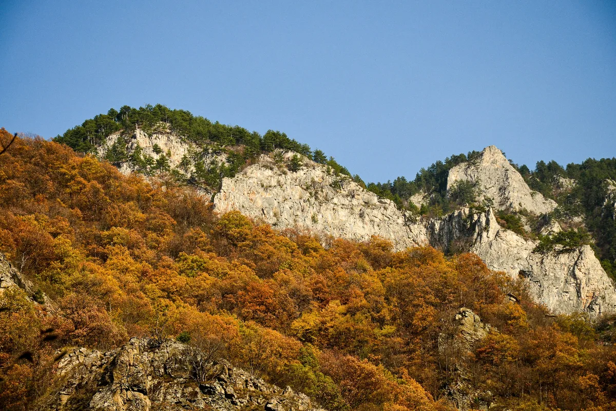
The park covers 81 square kilometers across Jeongeup City in Jeollabuk-do and Sunchang County, and it was designated the country's 8th national park in 1971. The Korean name means "mountain with hidden treasures" — a reference to the deep inner valleys ringed by eight peaks. Among those treasures: 11 species of maple, which is what makes the autumn display unusual. Most Korean mountains turn red. Naejangsan turns red, orange, gold, copper, and crimson at slightly different rates across different species, which is why photographers come here instead of anywhere else.
The signature view is Uhwajeong Pavilion — an octagonal Hanok-style pavilion rebuilt in 2016, sitting on a small island in Naejang Lake. On a windless autumn morning, the pavilion and the foliage behind it reflect in the water as a perfect mirror, and this is the single most photographed reflection shot in Korean autumn travel. Arrive before 7am or plan to queue.
Two ancient temples sit at the mountain's base: Naejangsa on the Jeongeup side and Baekyang-sa on the Jangseong side, both with roots in the Three Kingdoms era. A 688-meter cable car rises to 540 meters in five minutes for visitors who cannot or do not want to climb. And the eight-peak ridge traverse — 11.7 kilometers across the volcanic rim — is one of the more demanding day hikes in the southwestern provinces.
Quick Info
Quick summary for planning your Naejangsan hike at a glance.
- Location: Jeongeup City (Jeollabuk-do) / Sunchang County, South Korea
- Highest Peak: Sinseonbong, 763m
- Park Area: 81 km²
- Mountain Range: Noryeong Range
- Park Designation: 8th National Park (1971)
- Annual Visitors: ~1 million (500,000+ during autumn)
- Difficulty: Easy (Danpung Tunnel, Wonjeokgol) to Advanced (eight-peak traverse)
- Best Time to Visit: October 25 – November 5 (peak foliage)
- Entrance Fee: Free (Naejangsa Temple heritage fee ₩4,000)
- Parking: ₩5,000/day
- Seasonal Closures: Fire prevention — typically mid-March to mid-May and mid-November to mid-December
- Travel Time from Seoul: ~2 hours by KTX to Jeongeup
Trail Overview
| Trail | Distance | Elevation Gain | Time | Difficulty | Best For |
|---|---|---|---|---|---|
| Danpung Tunnel Walk | ~2.5km | minimal | 1–1.5h | Easy | Foliage, families, photography |
| Wonjeokgol Valley | 3.9km | +150m | 1.5–2h | Easy | Gentle forest walk, summer shade |
| Seoraebong | 5.9km | +400m | ~4h | Intermediate | Cliff views, fall panorama |
| Sinseonbong | 6–7km | +500m | 4.5–5h | Intermediate | Highest peak, Geumson Valley |
| Eight-Peak Ridge Traverse | 11.7km | +1,200m | 7–9h | Advanced | Full Naejangsan experience |
| Baekyang-sa ↔ Naejangsa Traverse | 12–15km | +800m | 8–10h | Advanced | Two temples, cross-provincial |
| Cable Car | 688m | 150m → 540m | 5 min | None | Accessibility, aerial views |
Why Naejangsan Is Korea's Autumn Capital
Every Korean mountain has a foliage season. Naejangsan has a reputation none of them can match, and the reason is specific.
The park holds 11 species of maple. Most Korean mountains are dominated by one or two, and the foliage shifts uniformly from green to red over two weeks. At Naejangsan, different maple species peak at slightly different times and in different colors — scarlet, orange, gold, copper, burgundy — and the effect is a layered, multi-toned canopy rather than a single red wash.
The Danpung Tunnel is the most concentrated expression of this. A roughly one-kilometer path from the ticket booth to Iljumun Gate passes under 108 ancient maples that form a natural archway overhead. The number 108 is deliberate — it mirrors the 108 defilements in Buddhist teaching — and the canopy on a clear October morning is as close as Korean hiking gets to walking through a cathedral.
Uhwajeong Pavilion adds the reflection shot that has become shorthand for Korean autumn. The octagonal pavilion was rebuilt in 2016 in traditional Hanok style on a small island in Naejang Lake, and on a windless morning the water surface turns the foliage into a perfect mirror. This is the image that ends up on Korean tourism posters every fall.
For comparison, Seoraksan's foliage is more dramatic against granite but the color palette is narrower. Jirisan's Piagol Valley holds color longer but covers a smaller area. Hallasan has stunning October views but the display there is about scale rather than species diversity. Naejangsan is where the species count, the temple architecture, and the reflection geometry all converge in one compact park — and why it is the mountain Koreans mean when they say they are going to see the autumn.
Difficulty and Time Required
Naejangsan spans a wide difficulty range, and the gap between the Danpung Tunnel walk and the eight-peak traverse is larger than at most Korean parks.
The Danpung Tunnel course is genuinely accessible — 2.5 kilometers of mostly paved path, minimal elevation gain, 1 to 1.5 hours at a leisurely pace. Wheelchair-accessible up to the Uhwajeong section. Any adult and most children can complete it.
The Wonjeokgol Valley trail is the gentlest natural-surface option in the park — 3.9 kilometers, about 150 meters of elevation gain, 1.5 to 2 hours. Heavy shade and stream crossings make it the best summer option. Suitable for older hikers and children aged 7 and up.
Seoraebong and Sinseonbong are the mid-tier summit routes. Both involve 400 to 500 meters of elevation gain over 5 to 7 kilometers, with rope-assisted sections on the steepest rock. These are not technical climbs but require hands-on-rock scrambling and a reasonable level of fitness. Plan 4 to 5 hours.
The eight-peak ridge traverse is an entirely different scale. Eleven-and-a-half kilometers of ridge hiking with a cumulative 1,200 meters of elevation gain across multiple summits, 7 to 9 hours. The ridge is exposed to wind, there is no water en route, and daylight management matters — especially in autumn when peak foliage coincides with shorter days. Experienced hikers only.
The Baekyang-sa ↔ Naejangsa traverse adds cross-provincial logistics and requires solid route-finding. Not a first-visit choice.
Trail Options
Danpung Tunnel Walk — Most Iconic
The signature walk of Naejangsan and the reason most visitors come. From the public parking lot, a multicolored maple pathway leads to the ticket booth, Uhwajeong Pavilion on its lake island, Iljumun Gate, the 108-maple Danpung Tunnel, and Naejangsa Temple.
Total distance is around 2.5 kilometers. The path is paved, mostly flat, and takes 1 to 1.5 hours at a relaxed pace. It is wheelchair-accessible as far as Uhwajeong.
The Uhwajeong reflection shot peaks October 25 through November 5 on a windless morning, ideally between 7 and 8:30am. Arrive by 7am for space at the water's edge. Afternoon light works for the Danpung Tunnel but crowds on October weekends are intense.
Best for: First-time visitors, families, photographers, autumn day trippers from Seoul.
Wonjeokgol Valley — Gentlest Natural Trail
From the Visitor Information Center, a 3.9-kilometer loop follows a pristine mountain stream up through Wonjeokgol Valley to Wonjeokam Hermitage and back. Elevation gain is around 150 meters, and the trail is 85 percent shaded by forest canopy — which makes it the park's best summer option.
The surface is dirt and wooden plank bridges over stream crossings. Rocks along the creek are slippery when wet, so non-slip footwear matters. The valley also contains Podocarpus nagi (bijanamoo) and Daphniphyllum specimens designated as natural monuments.
Seasonal note: the valley may close during fire-prevention periods, typically mid-March to mid-May and mid-November to mid-December.
Best for: Summer hikers, older visitors, children aged 7+, anyone wanting a quiet forest trail away from the autumn crowds.
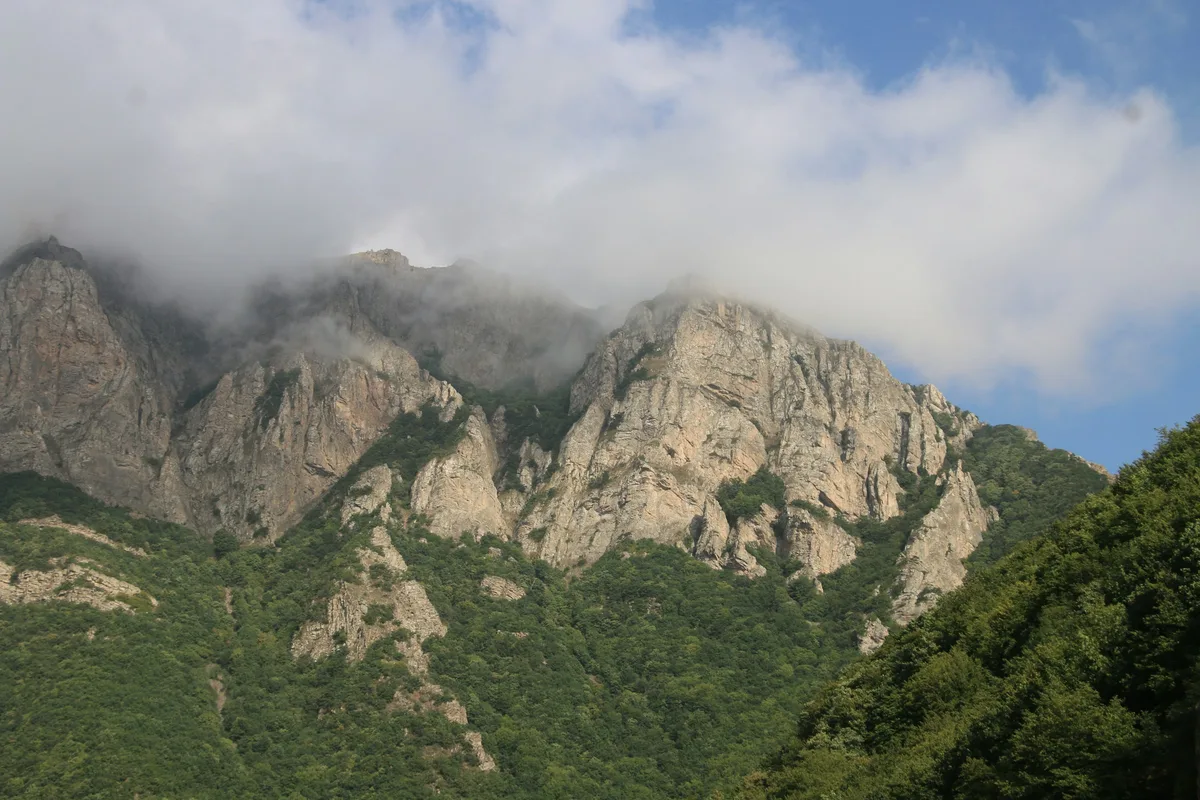
Seoraebong — Cliff Views and Rope Climbing
A 5.9-kilometer loop from Iljumun Gate up to Seoraebong (740m) via the striking Byeongnyeonam "wall lotus" rock formation, then back via Bulchulbong, Wonjeoktam, and Naejangsa Temple. Elevation gain around 400 meters, 4 hours at average pace.
About 20 percent of the route involves steep scrambling with fixed ropes and metal handrails on the rock sections. The handrails heat up in summer sun — bring gloves or pace yourself. After rainfall, the rock is extremely slippery; wait several hours before attempting. No water sources en route; carry at least 2 liters.
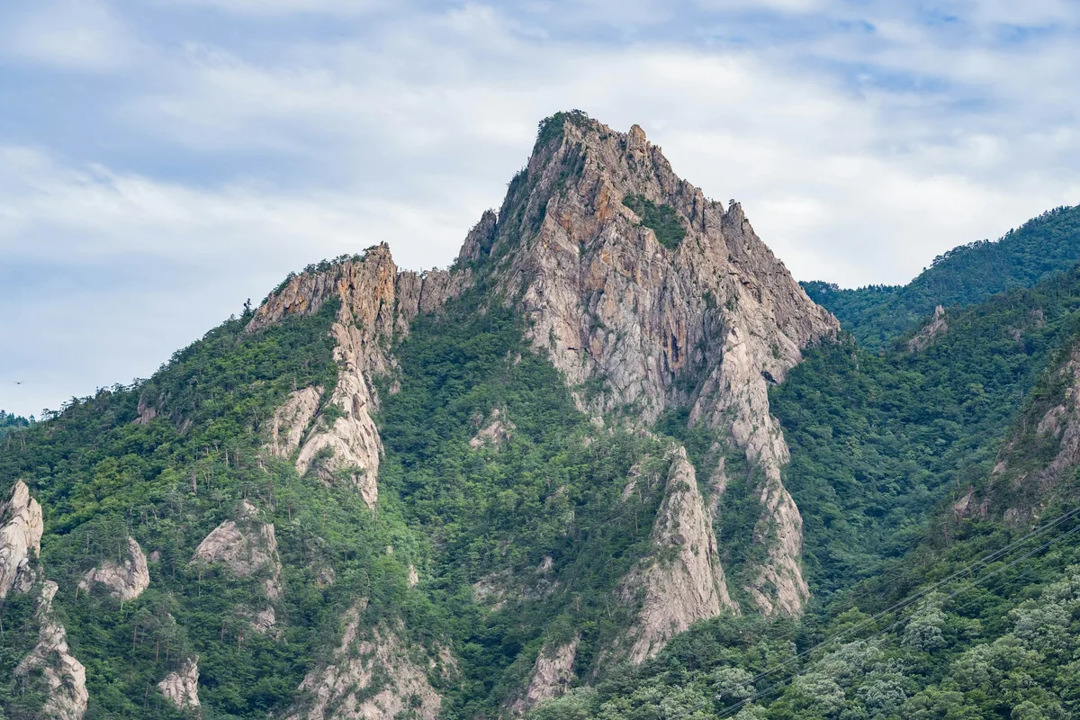
Byeongnyeonam — the vertical cliff that juts from the Seoraebong ridge — is the most photogenic formation in the park, best captured from the cable car or the summit deck. Autumn peaks on the summit foliage vista are unmatched; arrive by 4:30pm for sunset color.
Best for: Intermediate hikers wanting a half-day summit with dramatic rock scenery.
Sinseonbong — Naejangsan's Highest Peak
A 6 to 7-kilometer loop from Iljumun Gate through Naejangsa Temple and up Geumson Valley to Sinseonbong (763m), returning via Kkachibbong and back to the temple. Around 500 meters of elevation gain, 4.5 to 5 hours at average pace.
The route breaks into four phases: a gentle temple approach (30 minutes), the Geumson Valley floor with stream crossings (75 minutes), a steep switchback climb to the ridge (70 minutes), and a short final push with chain-assisted scrambling to the summit (20 minutes). Geumson means "embroidered silk" — named for the way the valley looks in full foliage — and it is the only reliable water point on the route. Carry at least 3 liters total.
The 360-degree summit panorama covers the full park, neighboring peaks, and the Jeongeup plain on clear days. In peak autumn, the valley reflection creates a "double autumn" effect in pools near the valley floor; arrive by 7am to photograph it before other hikers disturb the water.
Best for: Intermediate hikers who want the actual summit, valley-and-ridge combinations, autumn valley photography.
Eight-Peak Ridge Traverse — The Full Naejangsan
The park's signature hard day. Starting from Iljumun Gate, the route climbs to Seoraebong and then runs the full ridge across Bulchulbong, Manhaebong, Yeonjibong, Kkachibbong, Sinseonbong (the midpoint), Yeonjabong, and Janggunbong before descending via Donggulli Valley. Total distance 11.7 kilometers, cumulative elevation gain around 1,200 meters, 7 to 9 hours depending on pace and crowd density.
This is an up-down-up route rather than a sustained climb, which is psychologically and physically harder than a single summit. The ridge is exposed to wind, there is no water between trailheads, and rest shelters are open-air. In October peak season, single-file sections bottleneck; plan for weekday starts before 7am.
Safety essentials: minimum 3 liters of water, full meal provisions, rain layer, headlamp (winter starts must begin by 6am to finish before dark), charged phone, and notification to someone off-mountain of your planned route and expected return. The Naejangsan Ranger Station is at +82-63-538-7875.
Best for: Fit, experienced day hikers who regularly complete 8-hour outings.
Baekyang-sa ↔ Naejangsa Traverse — Advanced Two-Temple Route
A 12 to 15-kilometer cross-provincial traverse from Baekyang-sa Temple in Jangseong (Jeollanam-do) over the Naejangsan ridge via Sinseonbong and down to Naejangsa Temple in Jeongeup (Jeollabuk-do). Elevation gain around 800 meters, 8 to 10 hours.
There are no shelters, houses, or water sources between the two temples. Route-finding is the main challenge — minor junctions are ambiguous and a wrong turn can add hours. Emergency response time is longer due to the remote middle section. A local mountain guide, available at either temple, is strongly recommended for a first attempt (approximately ₩100,000–150,000).
Best for: Advanced hikers with solid navigation experience and a full day's daylight.
Cable Car — 688 Meters, Five Minutes
The Naejangsan cable car runs 688 meters from the lower station at 150 meters up to Yeonjabong observation deck at 540 meters. Ride time is about 5 minutes, adult round trip is ₩11,000 (children 6–12 half price, under 6 free), and operating hours are typically 9am to 5pm — extended to 6pm during peak foliage.
From the upper deck, the Byeongnyeonam cliff is visible in profile and the autumn foliage spreads across the park below. Standard combinations include a cable-car-only sightseeing visit, cable-car-up-hike-down to Naejangsa, or hike-up-cable-car-down from Seoraebong.
Peak season waits can exceed 30 minutes. Lines form by 10am on October weekends.
Best for: Visitors with mobility limits, families with young children, photographers wanting an aerial vantage, and bad-weather exits from a partial hike.
Best for Most Travelers
If you have a half day: the Danpung Tunnel walk — Uhwajeong reflection at the start, 108 maples overhead, Naejangsa Temple at the end. Roughly 2.5 kilometers, 1 to 1.5 hours at a relaxed pace.
If you have a full day: Danpung Tunnel + cable car + a short ridge walk from the upper station — combines the iconic ground-level view, the aerial perspective, and a taste of the ridge without the eight-peak commitment.
If you are a hiker with a full day and want to earn the view: Sinseonbong via Geumson Valley — the highest peak, the best valley, the full-park summit panorama. About 4.5 to 5 hours round trip.
If you are not sure: start with the Danpung Tunnel walk.
Who Should Do This Hike
Naejangsan works at almost every fitness level, but the experience is sharply different depending on which trail you choose. The Danpung Tunnel walk is the most accessible headline autumn experience in Korea — paved, short, visually overwhelming. Anyone visiting during foliage season should start there.
Serious hikers will want Sinseonbong or the full eight-peak traverse. Sinseonbong gives you the mountain's summit and its best valley in one day without the logistical weight of the full ridge. The traverse is the full park and belongs on a list alongside Jirisan's day hikes or Seoraksan's Daecheongbong route.
Photographers should plan specifically around October 25 through November 5, arrive at Uhwajeong before 7am for the reflection, and reserve a second morning for the Danpung Tunnel in side light. A tripod with an ND filter is worth carrying for long-exposure reflection shots.
Accessibility-focused visitors can combine the wheelchair-accessible Uhwajeong section with the cable car for an aerial perspective without strenuous walking.
Tips Before You Go
- Autumn peak is October 25 to November 5 at Uhwajeong and through roughly November 10 in the Danpung Tunnel. The window is short and the crowds are extreme — 100,000+ visitors per weekend are normal.
- Weekday visits reduce crowds by 30 to 50 percent. If you can hike Tuesday to Thursday during peak season, do it.
- Arrive by 7am during foliage season for parking, Uhwajeong light, and reflection photography without a queue.
- Fire-prevention closures typically run mid-March to mid-May and mid-November to mid-December. Check the Korea National Park Service website before you travel — closures can clip the tail end of the foliage window.
- Cable car waits hit 30 minutes or more on October weekends. Ride early or late in the day.
- Parking is ₩5,000 per day and the lot fills on peak weekends. Arrive before 8am or plan for shuttle/taxi access.
- Naejangsa Temple entry fee is ₩4,000 and is separate from park entry (which is free).
- Water — the ridge trails have no water sources. Carry 2 liters for Seoraebong, 3 liters for Sinseonbong or the traverse.
- Ridge safety — no shelters, limited mobile reception, and exposed weather. Lightning in afternoon thunderstorms (summer) is a real risk; descend at the first thunder.
- Rope sections heat up in summer sun and are slippery when wet. Wait several hours after rain before attempting Seoraebong or Sinseonbong.
- Emergency numbers: 119 (ambulance/fire/rescue), 112 (police), Naejangsan Ranger Station +82-63-538-7875, Tourist Info 1330.
How to Get There
From Seoul: The fastest route is KTX from Yongsan Station to Jeongeup Station (approximately 1 hour 40 minutes). From Jeongeup Station, a local bus or taxi to the main park entrance takes about 30 to 40 minutes. Total door-to-trailhead time from central Seoul is around 2.5 to 3 hours.
Driving takes approximately 3 hours via the Honam Expressway.
Public transit from Jeongeup: Jeongeup Bus Terminal has local buses to the Naejangsan entrance; frequency is limited, so check schedules the day before. Shared taxis are commonly arranged from the station and cost more but run on demand.
Peak-season shuttles: Private and hotel-arranged shuttles operate during foliage season (mid-October through mid-November). If you are staying in Jeongeup, the front desk can usually book one — this is the easiest way to avoid traffic and parking problems on October weekends.
Baekyang-sa trailhead (for the cross-provincial traverse): From Naejangsan, approximately 45 minutes by car via provincial roads. Parking at Baekyang-sa is limited; arrive early.
Use Naver Maps for real-time transit on the day.
Final Thoughts
Naejangsan is the mountain Korean autumn is built around. The 11 maple species, the 108 maples of the Danpung Tunnel, the mirror reflection at Uhwajeong, the ridge line running across eight peaks — the whole park is organized, deliberately and historically, around the three weeks each year when the foliage peaks.
The Danpung Tunnel walk delivers the iconic experience in under two hours. Sinseonbong delivers the summit. The eight-peak traverse delivers the full park. And a cable car ticket, a short queue, and a five-minute ride deliver the aerial view that no other Korean mountain offers at this elevation.
Every other Korean mountain is visited in four seasons. Naejangsan is visited in one. That is not a limitation — it is what makes the mountain what it is.
For the best hikes reachable directly from Seoul by subway, see the full Seoul hiking guide.
Related Guides
Explore more hiking in Korea:
- Best hikes in Seoul — full overview of Seoul's mountains by subway
- Jirisan Hiking Guide — mainland Korea's highest summit and ridge traverse
- Seoraksan Hiking Guide — Korea's most famous hiking destination
- Hallasan Hiking Guide — Jeju Island's volcanic UNESCO triple-crown summit
FAQ
When is the best time to visit Naejangsan for autumn foliage? October 25 through November 5 is the peak window, with the Danpung Tunnel holding color through roughly November 10. Arrive before 7am for Uhwajeong reflection photography, and choose weekday visits where possible — weekend crowds can exceed 100,000 visitors.
How difficult is the Naejangsan eight-peak ridge traverse? Advanced. It covers 11.7 kilometers with around 1,200 meters of cumulative elevation gain across eight summits in 7 to 9 hours. The route is not technical but the exposed ridge, lack of water, and daylight pressure require fitness and experience. Start early — before 7am in autumn, before 6am in winter.
Do I need a reservation for Naejangsan? No reservation is required for general park access. The park is free; Naejangsa Temple charges ₩4,000 for cultural heritage entry; parking is ₩5,000 per day. Cable car tickets are purchased on-site (₩11,000 adult round trip).
Can I visit Naejangsan as a day trip from Seoul? Yes. KTX from Yongsan Station to Jeongeup takes about 1 hour 40 minutes, and a local bus or taxi reaches the park entrance in another 30 to 40 minutes. A full-day visit with the Danpung Tunnel walk and the cable car is comfortably achievable from Seoul and back.
Is the cable car worth it? For most visitors, yes. The 688-meter ride to 540 meters takes 5 minutes and opens up the aerial foliage view that is impossible from the ground, plus a good angle on the Byeongnyeonam cliff. For mobility-limited visitors it is essential. During October weekends, expect waits of 30 minutes or more.
Is Naejangsan worth visiting outside autumn? Yes, but the experience is different. Spring (April–May) brings azaleas and strong waterfall flow in Geumson Valley. Summer is humid but Wonjeokgol Valley stays cool and shaded. Winter offers minimal crowds and frozen waterfalls for experienced hikers. The mountain is built around autumn, but the trails are worth hiking year-round.
Continue exploring Korea's mountains
More routes, same honest field notes.
Related guides

Same region
EasyByeonsanbando Hiking Guide: Sea Cliffs and Naesosa
A practical guide to hiking Byeonsanbando — Korea's only peninsular national park, with Chaeseokgang UNESCO sea cliffs, Jikso Falls, and Naesosa fir forest.

Same region
ModerateDeogyusan Hiking Guide: Gondola Summit and Valley
A practical guide to hiking Deogyusan National Park in Muju — the gondola route to Hyangjeokbong summit at 1,614m, Gucheondong Valley, and winter rime flowers.

Same region
ModerateMudeungsan Hiking Guide: Columnar Joints and Trails
A practical guide to hiking Mudeungsan National Park in Gwangju — the Jeungsimsa trail, Seoseokdae columnar joints, UNESCO Geopark status, and Seoul access.