Bukhansan Hiking Guide: Baegundae Summit in Seoul
A practical guide to hiking Bukhansan National Park in Seoul — Baegundae summit routes, Bukhansanseong Fortress, Insubong rock climbing, and subway access.

Bukhansan National Park sits at the northern edge of Seoul, spanning 77.334 square kilometers across four Seoul districts and three Gyeonggi Province cities. Its highest point, Baegundae, stands at 836.5 meters — the tallest peak within the capital's boundaries. The name Bukhansan means "mountain north of the Han River," and the park was designated Korea's 15th national park in 1983. It is one of the few national parks in the world located inside a capital city, and one of the most visited per unit area on the planet.
The mountain's granite landscape is the result of deep geological time. Bukhansan's bedrock is Daebo Granite — specifically classified as "Seoul Granite" — formed during the Middle Jurassic period roughly 160 million years ago. That makes it approximately 80 million years older than Seoraksan's granite. Millions of years of tectonic uplift and differential erosion carved the massive domes, towers, and vertical faces that define the skyline today. Insubong, at 810.5 meters, is a textbook bornhardt — a bare granite dome that has become the single most important rock climbing site in Korea.
Below the peaks runs a 12.7-kilometer stone fortress. Bukhansanseong was built in 1711 under King Sukjong as the last-resort defense line for the Joseon capital, constructed after the devastating invasions of the Imjin War and the Byeongja Horan. Fourteen gates — five arched and nine hidden — punctuate the walls, and a garrison of warrior monks maintained the fortress from eleven temples built within its perimeter. The fortress is a designated historic site.
The cultural layer runs deeper still. Roughly 30 Buddhist temples occupy the mountain's slopes, including Doseonsa, founded during the Unified Silla period; Jingwansa, built under Goryeo King Hyeonjong in 1010; and Seunggasa, a Silla-era temple known for its cliff-carved seated Buddha (a designated Treasure). Legend holds that Bukhansan is where the founders of Baekje surveyed the land before establishing their capital, and where the monk Muhak read the geomantic lines for Joseon's capital.
Quick Info
Quick summary for planning your Bukhansan hike at a glance.
- Location: Northern Seoul (Dobong-gu, Gangbuk-gu, Jongno-gu, Eunpyeong-gu) and Gyeonggi Province (Goyang, Yangju, Uijeongbu)
- Highest Peak: Baegundae, 836.5m
- Park Area: 77.334 km²
- National Park Since: 1983 (Korea's 15th national park)
- Geology: Daebo Granite ("Seoul Granite"), Middle Jurassic (~160 Ma)
- Key Peaks: Baegundae (836.5m), Insubong (810.5m), Mangyeongdae (787m), Munsubong (727m), Nojeokbong (716m)
- Difficulty: Easy (Dulle-gil) to Strenuous (Baegundae via Fortress)
- Best Time to Visit: April–June (spring greenery, azaleas), October–November (peak foliage)
- Entrance Fee: Free
- Park Hours: March–November 04:00–17:00 / December–February 04:00–16:00
- Emergency: 119 + location marker number (758 markers installed park-wide)
Trail Overview
| Trail | Distance | Elevation Gain | Time | Difficulty | Best For |
|---|---|---|---|---|---|
| Baegundae via Bukhansan Ui Station | 4.4km one-way | +590m | 3–4h round trip | Medium | Most popular summit route, direct subway access |
| Baegundae via Bukhansanseong Fortress | ~7km one-way | +590m | 4–6h round trip | Medium–Hard | Fortress gates, temples, historical route |
| Bibong Loop (Samobawi Rock) | ~8km | varies | 4–5h | Medium | Fortress ridge views, tafoni geology, sunset |
| Doseonsa Temple Route | ~3km one-way | varies | 2.5–3h to summit | Medium | Shortest summit approach, temple visit |
| Bukhansan Dulle-gil | 71.5km total (21 sections) | minimal per section | varies | Easy | All fitness levels, flat perimeter trail |
Why Bukhansan Is Seoul's Granite Cathedral
Three facts set Bukhansan apart from every other mountain in this guide. First, it is reachable by subway from central Seoul in under an hour. Second, it contains a national-park-scale wilderness — 77 square kilometers of granite peaks, forested valleys, and 2,397 documented species — within a metropolitan area of 25 million people. Third, it carries more concentrated history per trail kilometer than any other Korean mountain: fortress walls, royal legends, rock-carved Buddhas, and the origins of Korean rock climbing all sit within the same park boundary.
The geological foundation explains the scenery. Bukhansan's Daebo Granite, formed roughly 160 million years ago during the Middle Jurassic, has been sculpted by erosion into a catalogue of weathering landforms. Insubong is a classic bornhardt — a massive bare dome. Baegundae's summit block is a tor, a tower of rock left standing as surrounding material eroded along joint planes. Across the park, tafoni (honeycomb weathering holes) pit the rock surfaces at Samobawi, sheet joints create the smooth slabs that climbers ascend on Insubong, and gnamma (rock-surface pools) dot the ridgelines. Geologists treat the park as a field textbook of granite weathering — a natural outdoor geology museum.
The historical density is equally unusual. The Bukhansanseong Fortress walls connect 14 gates across 12.7 kilometers of ridgeline, with the core wall itself measuring 8.4 kilometers. The fortress interior once held an emergency palace, 143 barracks, 8 armories, 99 wells, and 26 ponds — a self-sufficient citadel designed for prolonged siege. Below the walls, warrior monks from eleven garrison temples formed the backbone of the defense force, an arrangement that reveals the paradox of Joseon Buddhism: officially suppressed, militarily essential.
For visitors planning a broader Korea itinerary, Bukhansan is the natural starting point. Hallasan is higher and holds UNESCO triple-crown status, Jirisan offers multi-day ridge traverses, and Seoraksan has more dramatic alpine scenery — but none of them can be reached from a subway station before breakfast and returned from by lunch.
Difficulty and Time Required
Bukhansan's difficulty depends entirely on which route you choose and which section you are on. The same mountain that offers flat, paved Dulle-gil walking also has a final 300-meter summit approach that involves fixed metal ropes, exposed granite slabs, and genuine drops on either side.
Baegundae via Bukhansan Ui Station is the most popular route: 4.4 kilometers one-way, roughly 590 meters of elevation gain, 3 to 4 hours round trip. The first kilometer is a gentle valley walk along a stream. The gradient increases sharply after Harujae Ridge, and the final 300 meters require hand-over-hand movement on carved rock steps with metal rope handholds bolted into the granite. This section is not technically difficult but it is exposed, and the granite becomes dangerously slippery after rain.
Baegundae via Bukhansanseong Fortress is longer at approximately 7 kilometers and harder: 4 to 6 hours round trip. The route passes through Daeseomun Gate, climbs along fortress walls, and approaches the summit through Yongambong and Baegunbongammun (Baegundae hidden gate). The sustained elevation and the additional distance make this meaningfully more demanding than the eastern approach.
Bibong Loop covers roughly 8 kilometers over 4 to 5 hours at intermediate difficulty. The route takes in the fortress ridge, Samobawi Rock with its distinctive tafoni weathering, and Bibong peak at 560 meters — one of the best sunset viewpoints in the park.
Doseonsa Temple Route is the shortest summit approach at approximately 3 kilometers one-way, 2.5 to 3 hours to the summit. It passes through Doseonsa Temple before joining the upper ridgeline.
Bukhansan Dulle-gil is a separate category entirely. The 71.5-kilometer perimeter trail, opened in 2010 to 2011 across 21 sections, stays on flat or gently rolling terrain and is suitable for all fitness levels including families with young children and elderly walkers.
Weekend congestion is a real factor. The final rope section on the Bukhansan Ui route can generate 20 to 30-minute queues on Saturday mornings in October. Start before 8:00 AM or visit on a weekday to avoid peak crowds.
Trail Options
Baegundae via Bukhansan Ui Station — The Eastern Approach
This is the standard Baegundae route and the most direct from central Seoul. From Bukhansan Ui Station (Ui-Sinseol Light Rail), the trailhead is a 30 to 40-minute walk or short taxi ride.
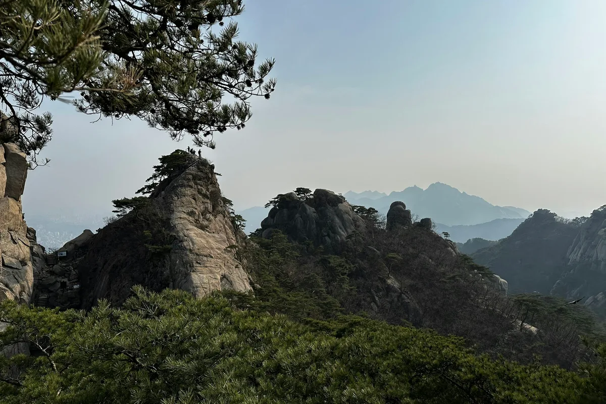
The first kilometer follows a paved path alongside a small stream, passing stone walls and a cluster of small temples. The gradient is gentle and the canopy provides shade. After roughly 40 minutes, the terrain shifts abruptly. Wide steps give way to irregular rock stairs, and the trees thin as you gain elevation. At Harujae Ridge — roughly the 700-meter elevation mark — the trail flattens briefly and Baegundae's granite face appears directly ahead: larger and closer than expected. This is the best mid-route photograph of the summit.
Above Harujae, the path alternates between rocky steps and short scrambles with occasional metal handrails. Insuam hermitage sits quietly off to the side of the trail. Baegundae Shelter, about 500 meters below the summit, marks the last toilet facility. Many hikers eat here before the final push.
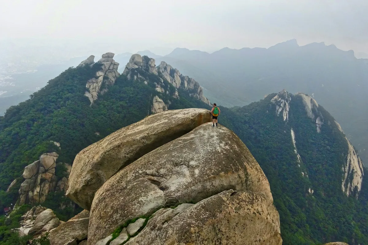
The final 300 meters is where Bukhansan becomes a different experience. The trail narrows to rock-carved stairs, then opens onto exposed granite slabs with fixed metal ropes bolted into the rock face. The exposure is real — significant drops on either side — but the handholds are secure and the path is clearly defined. Keep three points of contact on the steeper sections.
The summit delivers a 360-degree Seoul panorama: Namsan Tower, the Han River, Lotte World Tower, and on clear days the mountains of Gyeonggi Province in every direction.
Best for: First-time Bukhansan visitors, hikers staying in Seoul, anyone who wants the most direct subway-to-summit route.
Baegundae via Bukhansanseong Fortress — The Western Approach
The fortress route starts from Bukhansanseong Fortress entrance, reached by bus from Gupabal Station (Line 3). At approximately 7 kilometers one-way and 4 to 6 hours round trip, it is the longer and harder approach to Baegundae, but it passes through the most historically significant terrain in the park.
The trail enters through Daeseomun (Great West Gate), one of the five arched gates of the 1711 fortress. From here the route follows fortress walls and passes multiple temples that once housed warrior monks. The ascent continues through Yongammun (Dragon Rock Gate) and Baegunbongammun (Baegundae hidden gate) before joining the final summit ridge. Sections of the 300-year-old fortress wall are visible throughout, and the scale of the construction — 8.4 kilometers of stone wall connecting peaks — becomes tangible only from this approach.
Several temples are accessible as side stops along this route, including remains of the garrison monasteries that formed the fortress's standing defense. The cultural density here is higher than on the eastern approach, and the route is less crowded on weekday mornings.
Best for: History-oriented hikers, visitors who want the fortress experience, second-time Bukhansan visitors who have already done the Ui Station route, photographers interested in fortress gate compositions.
Bibong Loop — Fortress Ridge and Samobawi Rock
The Bibong Loop covers roughly 8 kilometers over 4 to 5 hours, traversing the fortress ridgeline through Seungga Peak, Munsu Peak, and Bibong at 560 meters. The route includes Samobawi Rock, a formation notable for its tafoni — honeycomb-pattern weathering holes carved into the granite surface over millions of years — which makes it both a geological point of interest and one of the most photographed rock formations in the park.
Bibong itself is one of the best viewpoints for the fortress wall ridgeline and western Seoul. In the afternoon, the light angle across the fortress walls and the city skyline beyond produces conditions that bring serious photographers to this spot specifically for sunset.
The loop does not reach Baegundae summit. It covers different terrain entirely — the fortress ridge system rather than the main peak — and is worth treating as a separate hike rather than a variant of the summit routes.
Best for: Fortress ridgeline views, tafoni geology at Samobawi, sunset photography from Bibong, hikers who prefer ridge walking to summit scrambling.
Insubong Rock Climbing — Reference Section
Insubong is not a hiking trail. It is an 810.5-meter granite dome with approximately 90 established climbing routes, and it is the single most important rock climbing site in Korea. General hiking access to Insubong's summit is not possible — it requires technical climbing equipment, experience, and gear.
The climbing history is significant. Rock climbing on Insubong dates to the Japanese colonial period. In the 1960s, Yvon Chouinard — later the founder of Patagonia — opened routes on the face while stationed in Korea with the US military, working alongside Korean climber Seon U Jung-ok. The Chouinard A and B routes date from this period. Today, the most well-known route is an 11-pitch comprehensive course, with the diagonal crack on the 6th pitch considered the crux.
On weekends and holidays, more than 300 climbers work the face simultaneously. The granite's sheet joints create smooth slab surfaces ideal for friction climbing — a technique specific to Insubong's geology.
For hikers who want to see Insubong without climbing it, the best frontal view is from Yeongbong (604 meters), accessible via the Ui Station approach. The view of snow-covered Insubong in winter — white granite against grey sky — is considered the most dramatic single mountain view in the Seoul area.
Best for: Experienced rock climbers with full gear and partner (not for general hikers). For viewing: Yeongbong viewpoint from the Ui Station route.
Bukhansan Dulle-gil — The 71.5-Kilometer Perimeter Trail
The Dulle-gil is a flat-to-gentle perimeter trail circling the park in 21 sections, opened between 2010 and 2011. It was designed specifically to absorb visitor pressure away from the summit routes and to provide mountain access for people who cannot manage steep terrain: elderly walkers, families with young children, visitors recovering from injuries, and anyone who prefers forest walking to scrambling.
Individual sections range from 2 to 5 kilometers and can be completed in 1 to 2 hours each. The trail stays in the lower elevations, following forest paths, stream valleys, and residential boundaries. It is not a summit experience — but it passes through the same national park ecosystem, with 2,397 documented species including 18 listed as endangered wildlife.
Best for: All fitness levels, elderly visitors, families with young children, anyone wanting a forest walk without summit ambition, multi-visit exploration of the park's perimeter.
Best for Most Travelers
If you have one day in Seoul and want to summit: Baegundae via Bukhansan Ui Station. Direct subway access, 3 to 4 hours round trip, and the 360-degree summit view is the single best panorama available from any point inside Seoul. Start before 8:00 AM on weekends.
If you want the fortress and history: Baegundae via Bukhansanseong Fortress. Longer and harder, but the Daeseomun gate passage and the fortress wall sections add a dimension that the eastern approach lacks. Budget 4 to 6 hours.
If you are not sure about the summit scramble or have limited fitness: Bukhansan Dulle-gil. Any single section gives you forest, stream valleys, and national park ecology without steep terrain or exposed rock.
Who Should Do This Hike
The Baegundae summit routes suit hikers who are comfortable on uneven terrain and do not mind using their hands on the final rope section. The route is not technically difficult, but the last 300 meters involves exposure, and the granite surface becomes dangerously slippery after rain. If conditions are wet, either delay your summit attempt or choose a different route in the park.
The trail is not suitable for very young children, anyone with a significant fear of heights, or visitors in casual footwear on the summit routes. Trekking poles help on the descent but become awkward on the final rope section — most hikers clip them to their pack.
The Dulle-gil and lower valley trails are accessible to most adults in reasonable fitness with any proper footwear. They do not involve exposed sections or technical terrain.
Bukhansan is a reasonable first mountain in Korea for visitors with some hiking background. Bilingual trail signs (Korean and English), subway access, and well-marked routes make navigation straightforward. For a gentler Seoul introduction, consider Inwangsan or Achasan first. For a more demanding day, Dobongsan — within the same national park north of Uiryeong Pass — offers similar granite with fewer crowds.
Winter hiking on Bukhansan requires crampons on icy sections, particularly the final summit approach. Crampons are available for purchase near trailheads for around 20,000 KRW.
Tips Before You Go
- Wear proper hiking shoes. The final Baegundae section requires grip on steep granite. Trail runners or flat-soled shoes create real risk on the rope sections.
- Bring at least 1.5 liters of water. There are no vendors or water sources once you enter the park. In summer, carry 2 liters.
- Gloves are useful on the fixed rope sections, especially for descent when grip matters more.
- Start early. Weekend peak congestion on the Ui Station route builds from 9:00 AM onward. Arriving before 8:00 AM avoids the worst queues at the summit rope section. Weekdays are significantly less crowded.
- Check weather before going. Granite becomes dangerously slippery when wet. If it has rained in the past 24 hours, either delay the summit attempt or switch to the Dulle-gil.
- In winter, crampons are essential for the upper sections. Available for purchase near trailheads for approximately 20,000 KRW.
- Emergency location markers are installed at 758 points throughout the park. Each has a unique ID number. In an emergency, call 119 and read out the marker number for precise rescue dispatch. There are also 58 emergency first-aid boxes at key points.
- Free gear rental is available at the Baegundae Visitor Support Center: hiking boots, trekking poles, backpacks, knee braces, crampons (winter), emergency kits, and trail maps — all free of charge. This is particularly useful for international visitors without gear.
- Trail signs are bilingual in Korean and English throughout the park, including maps and emergency markers.
- Leave No Trace. There are no trash bins in the park — carry everything out, including food scraps. Off-trail hiking is prohibited. Wondobong Valley and Hoeryong Valley are designated Special Protection Areas with entry completely banned to protect aquatic ecosystems.
- Safety context: Bukhansan recorded the most mountain rescue cases in Seoul over a three-year period (6,191 total city-wide), with 85 fatalities over ten years. The main risks are slips on granite, falls, hypothermia, and exhaustion. Respect the terrain.
How to Get There
Eastern Approach — Bukhansan Ui Station (Ui-Sinseol Light Rail): Take the Ui-Sinseol Light Rail to Bukhansan Ui Station, Exit 2. The trailhead is approximately a 30 to 40-minute walk (2 kilometers) or a short taxi ride. Total travel time from central Seoul is approximately 40 to 50 minutes. This is the most direct route to Baegundae.
Western Approach — Gupabal Station (Line 3): Exit at Gupabal Station (Exit 1 or 2) and take Bus 34, 704, or 720 to the Bukhansanseong Fortress entrance (북한산성입구). Total travel time from central Seoul is approximately 50 to 70 minutes. This approach leads to the fortress route and is the starting point for the western summit approach.
Southern Approach — Gireum Station (Line 4): Exit at Gireum Station (Exit 3) and take Bus 110B or 143 to the Jeongneung entrance. This provides access to the southern slopes and connects to several mid-park trails.
Use Naver Maps or Kakao Map for real-time transit directions on the day — bus schedules and connections vary.
Final Thoughts
Bukhansan compresses an unusual amount into 77 square kilometers: Jurassic granite sculpted into domes and towers, a 12.7-kilometer Joseon fortress with fourteen gates, thirty temples spanning a millennium of Buddhist history, the birthplace of Korean rock climbing, and a summit panorama that takes in the entire Seoul metropolitan area. It does all of this within subway range of a city of ten million people.
If you climb Baegundae on a clear morning — passing through the forest, over the ridge, up the final rope section to the 836.5-meter summit — the view takes in everything Seoul is built around. Namsan Tower to the south, the Han River curving through the city, Dobongsan's granite spires to the north.
For a second visit, the Bibong Loop covers entirely different ground — fortress ridgeline, Samobawi Rock's tafoni geology, and sunset views that the summit routes do not offer. For a broader overview of Seoul's mountain options, see the full Seoul hiking guide.
Related Guides
Explore more hiking in Korea:
- Dobongsan Hiking Guide — granite peaks within the same Bukhansan National Park, north of Uiryeong Pass
- Gwanaksan Hiking Guide — rugged ridge walk on Seoul's southern edge
- Inwangsan Hiking Guide — Seoul Fortress Wall trail with city views
- Suraksan Hiking Guide — granite ridge between Seoul and Uijeongbu
- Best hikes in Seoul — full overview of Seoul's mountains by subway
FAQ
Is Bukhansan National Park hiking suitable for beginners? The lower sections and the Dulle-gil perimeter trail (71.5 kilometers across 21 flat sections) are accessible to most fitness levels. The Baegundae summit routes involve steep rock and fixed metal ropes in the final 300 meters and are better suited to hikers with some mountain experience. Free gear rental is available at the Baegundae Visitor Support Center for visitors without equipment.
How difficult is the hike to Baegundae Peak? The Bukhansan Ui Station route is rated medium difficulty overall. The first half is a gentle valley walk; the second half steepens significantly. The final 300 meters involves scrambling on exposed granite with metal rope handholds. After rain, the granite becomes dangerously slippery and summit attempts should be delayed.
What is the best time to hike Bukhansan? Spring (April to June) and autumn (October to November) offer the most pleasant conditions. Mid-October is peak foliage season and the most popular period — expect summit queues on weekends. Summer is hot and humid. Winter hiking is possible with crampons but requires caution on icy granite.
How do I get to Bukhansan from central Seoul? The most direct route is the Ui-Sinseol Light Rail to Bukhansan Ui Station (eastern approach, 40 to 50 minutes from central Seoul). For the fortress route, take Line 3 to Gupabal Station and Bus 34, 704, or 720 to Bukhansanseong entrance (50 to 70 minutes total).
What is Bukhansanseong Fortress? A 12.7-kilometer stone fortress built in 1711 under King Sukjong as the final defense line for the Joseon capital. The fortress has 14 gates, and warrior monks from eleven garrison temples formed the core defense force. Sections of the wall are accessible on the western summit route and the Bibong Loop.
Can I climb Insubong? Not by hiking. Insubong is a technical rock climbing site requiring full climbing gear, experience, and a climbing partner. It has approximately 90 established routes and is considered the most important rock climbing location in Korea. For viewing, the best frontal perspective is from Yeongbong peak (604 meters) on the Ui Station approach route.
Continue exploring Korea's mountains
More routes, same honest field notes.
Related guides

Nearby hikes
EasyAchasan Hiking Guide: Han River Views and Sunrise
A practical guide to hiking Achasan in Seoul — the main summit route, the Achasan-Yongmasan ridge traverse, Han River sunrise views, and subway directions.

Nearby hikes
ModerateBulamsan Hiking Guide: Granite Ridge and Azaleas
A practical guide to hiking Bulamsan in northeast Seoul — the Sanggye route, Hwangangdae technical scramble, spring azaleas, and how to get there by subway.

Nearby hikes
ModerateCheonggyesan Hiking Guide: Routes and Waterfalls
A practical guide to hiking Cheonggyesan near Seoul — the Wonteogol valley route, ridge traverse to 618m, hidden waterfalls, and subway access from Gangnam.