Achasan Hiking Guide: Han River Views and Sunrise
A practical guide to hiking Achasan in Seoul — the main summit route, the Achasan-Yongmasan ridge traverse, Han River sunrise views, and subway directions.

Achasan is 287 meters tall and sits on Seoul's eastern edge, where the Han River turns and the city opens up toward Gyeonggi Province. It is one of the best easy hikes in Seoul for a single specific reason: the ridge looks directly west over the Han River and the full eastern Seoul skyline, and at sunrise that view is one of the most open and unobstructed in the metropolitan area.
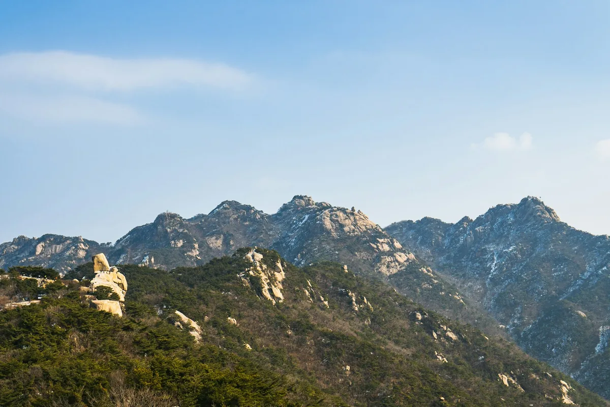
Geologically, Achasan is composed of granite — the same crystalline igneous rock that underlies much of inner northern Seoul. The granite bedrock was formed through ancient magma intrusion during the Precambrian and Paleozoic periods and has been exposed through tectonic uplift and erosion. Spheroidal weathering has produced the rounded boulders and rocky outcrops visible along the ridge, and the exposed granite faces create stable but slippery footing when wet. The mountain connects via ridgeline to Yongmasan (376 meters), Suraksan, and Mangwusan, forming a continuous chain along Seoul's eastern boundary.
The mountain is also historically unusual. The ridge holds a network of 17 to 20 Goguryeo-era military fortlets — small garrisons built between 476 and 551 CE to control the Han River valley — designated as National Historic Site #455. These fortlets, or borugun, were not standalone forts but an integrated defensive network: each measuring 100 to 300 meters in circumference, spaced closely enough for communication and mutual defense, with an estimated 50 to 200 soldiers stationed at each post. The system was built after Goguryeo captured Baekje's capital Hanseong in 475 CE and maintained for roughly 70 to 100 years until Silla and Baekje pushed Goguryeo out of the Han River basin in 551 CE.
The cultural layer extends beyond military history. Yeonghwasa Temple, originally founded in 672 CE by the Silla monk Uisang as Hwayangsa on the slopes below Yongmabong, has been relocated multiple times over the centuries — to Gunjadong in 1395, then to Junggokdong, and finally to its current location in 1907 when it was renamed Yeonghwasa. The temple houses a Maitreya Buddha stone statue approximately 3.5 meters tall, believed to date from the late Goryeo period roughly 800 years ago. Several other temples — including Gwangjinsa, Daeseongam, and Beomgulsa — dot the mountain, reflecting a continuous Buddhist presence since the Goryeo dynasty.
Quick Info
Quick summary for planning your Achasan hike at a glance.
- Location: Gwangjin-gu, Seoul / Guri City border, South Korea
- Summit: Achasan 287m / Yongmasan 376m (ridge traverse)
- Difficulty: Easy to Intermediate
- Best Time to Visit: Year-round — sunrise hikes and autumn foliage particularly popular
- Entrance Fee: Free
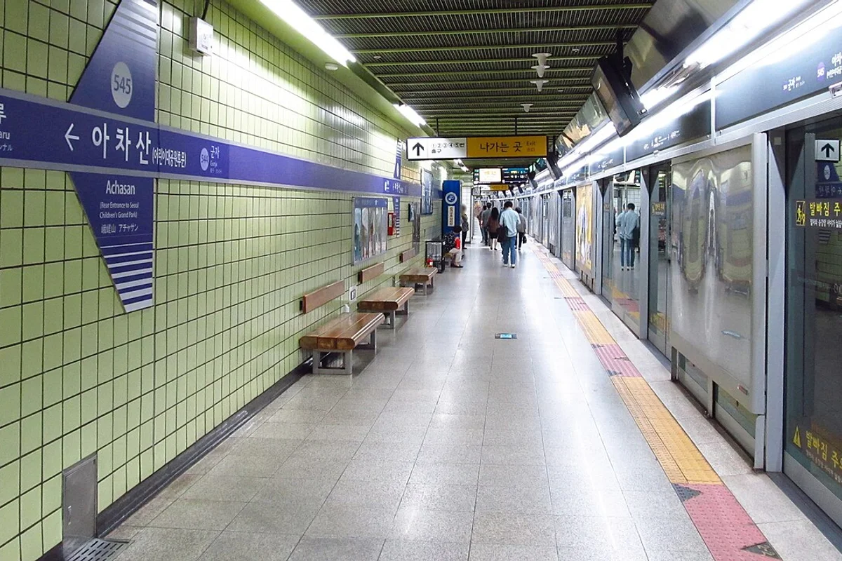
- Nearest Station: Achasan Station (Line 5, Exit 1) or Gwangnaru Station (Line 5)
- Travel Time from Central Seoul: 30–40 minutes
Trail Overview
| Trail | Distance | Elevation Gain | Time | Difficulty | Best For |
|---|---|---|---|---|---|
| Main Summit Route | 2–2.5km one-way | +287m | 1–1.5h | Easy | First-timers, sunrise hike |
| Achasan–Yongmasan Ridge | 4.5–5.2km total | ~200m net | 2.5–3h | Intermediate | Ridge walking, Han River views |
| Gwangnaru Ecological Park Loop | ~3km | varies | 1.5h | Easy | Families, nature walk |
Why Achasan Is Worth It
Achasan does not have the dramatic granite faces of Bukhansan or the technical ridge of Dobongsan. What it has is position — and for a sunrise hike or an afternoon walk with Han River views, that position is hard to beat.
The summit faces directly west across the Han River. On a clear morning, with the light coming up behind you, the view takes in the river, the bridges, and the eastern districts of Seoul in a single unbroken panorama. This is the cleanest Han River viewpoint available from any peak within Seoul's city boundary — better for the river view than Namsan, which faces inward toward the city center.
The historical layer adds something the other easy Seoul hikes largely lack. The Achasan Borugun — the network of Goguryeo military fortlets that ran along this ridge — represents one of the most significant Three Kingdoms period archaeological sites in the Seoul region. The fortlets were built between 476 and 551 CE to control the Han River crossing, and several excavated sites remain visible along the ridge traverse to Yongmasan. The fortlets are distributed across Hongnyeonbong (1 to 2 forts), Achasan peak (1 to 5 forts), Yongmasan (1 to 7 forts), Sirubong, Suraksan, and Mangwusan — an integrated early warning and defense system stretching across Seoul's eastern ridgeline.
The most famous figure associated with this site is General Ondal, one of Goguryeo's most celebrated commanders. According to the Samguk Sagi, Ondal was of humble origins — dismissed as a "fool" in his youth — until Princess Pyeonggang, daughter of King Pyeongwon, left the palace at age 16 to marry him. She sold her golden bracelets to establish their household, trained horses for his military campaigns, and helped him rise from obscurity to one of Goguryeo's most successful generals. In 591 CE, Ondal led forces to recover territory south of Jukryeong Pass from Silla and was killed by an arrow at Achasanseong Fortress. The legend says his coffin would not move until Princess Pyeonggang came and gave him her blessing — a story that remains one of the most enduring love narratives from the Three Kingdoms period. Ondal Spring (Ondal Yaksu), a small spring on the mountainside, is named after the legend that his troops drank from it.
Achasanseong Fortress itself — recorded as Adanseong in the Samguk Sagi — was also the site where Baekje's King Gaero was killed by Goguryeo forces, marking Baekje's loss of control over the Han River basin. The fortress thus witnessed two of the most significant individual deaths in Three Kingdoms military history.
For more demanding hikes in eastern Seoul, the Achasan-Yongmasan ridge connects to a longer network that extends north toward Suraksan.
Difficulty and Time Required
The main summit route is genuinely easy — mostly packed dirt trail with some stone steps, no scrambling, and clear signage throughout. It takes 1 to 1.5 hours at a comfortable pace. Most people in any fitness level complete it without difficulty.
The ridge traverse to Yongmasan adds a moderate section near the Yongmasan summit where the trail becomes rocky and requires careful footing. There is some exposure on the right side of the ridge near Yongmasan with a significant drop. It is not technical but warrants attention, particularly in wet conditions.
Trail Options
Main Summit Route — Best for Sunrise and Beginners
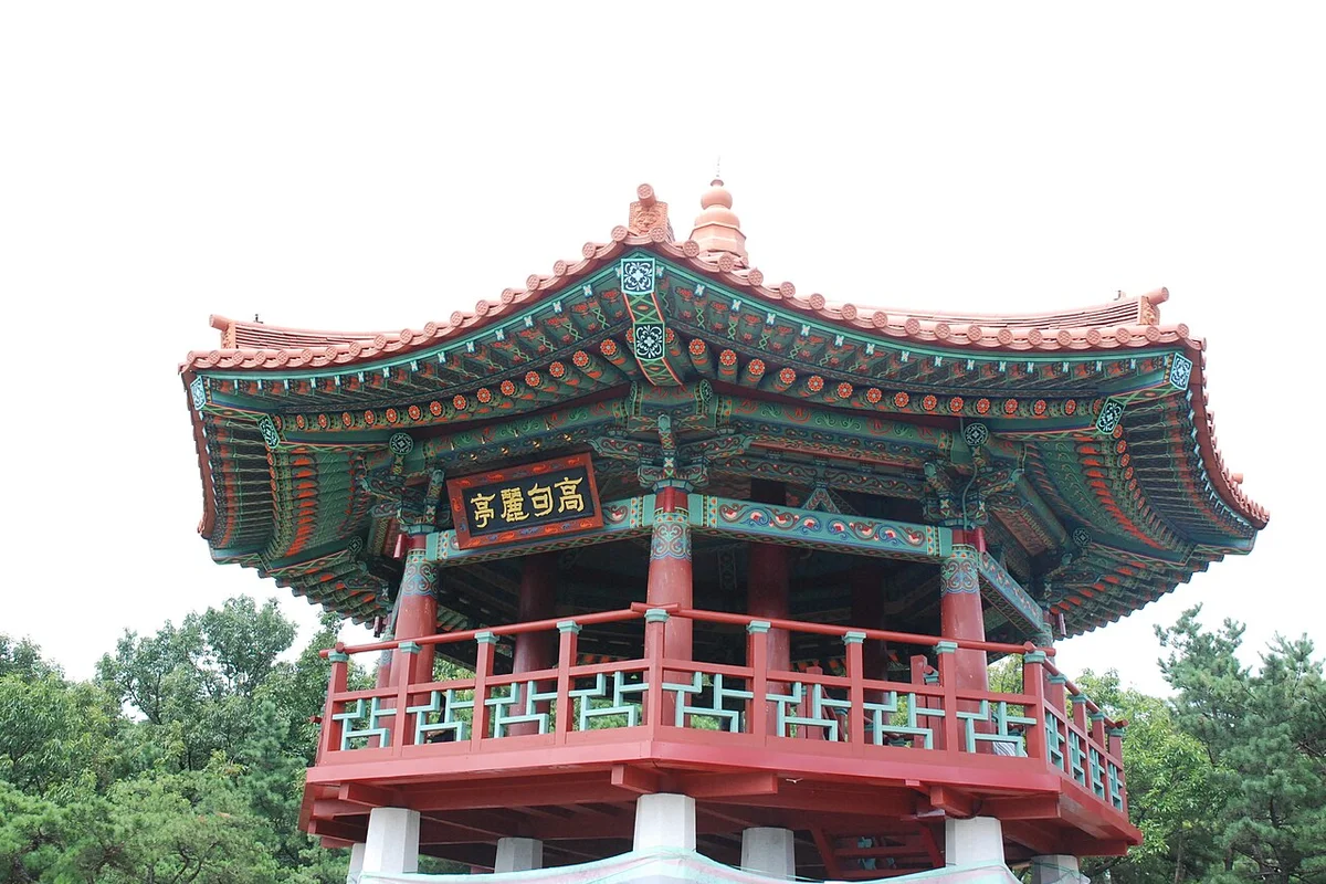
Starting from Achasan Station (Line 5, Exit 1), the trail begins with a 10 to 15 minute walk through a residential area before entering the forested approach. The first section follows a gentle uphill through deciduous forest. Around the 1.2-kilometer mark, the gradient increases and the first views of the Han River begin to appear from the Goguryeo Pavilion rest area — a good intermediate stop with a clear westward view.
The final push to the summit involves mixed dirt and stone steps. The summit itself has a marker, clear signage, and an open view to the west and south. On a clear morning, the Han River is visible in both directions from the ridge, and on days with good visibility Namsan and Seoul Tower are visible to the west.
For sunrise: Achasan Station opens at approximately 5:30am. The walk to the summit takes about 1 hour. Check sunrise times for your visit date — arriving 20 minutes before sunrise gives you time to position on the ridge. The Haemaji (Sunrise) Plaza near the base hosts formal photo zones during the New Year period, when crowds begin gathering as early as 3:00am.
Guri City approach: Hikers coming from Guri City can access Achasan from the northeast side via buses from Guri Station. The Guri approach is longer but offers views toward the east and Gyeonggi Province that the Seoul-side routes do not provide. This side of the mountain is quieter on weekends.
Best for: Beginners, sunrise hikes, visitors wanting Han River views without a long commitment.
Achasan–Yongmasan Ridge Traverse — Best Overall Experience
From the Achasan summit, the ridge continues northeast toward Yongmasan (376 meters), the highest point of the traverse. The 1.8-kilometer ridge section between the two summits is the best part of the hike — mostly flat or gently rolling terrain with woodland on both sides and occasional granite outcrops. This stretch passes through the Achasanseong Fortress area and near excavated Goguryeo fortlet sites, with interpretation signs in Korean and English.
The final approach to Yongmasan involves rocky scrambling for 10 to 15 minutes with some exposure. From the Yongmasan summit, the Han River view opens up again from a higher angle. Descent to Yongma Station (Line 5) or back to Achasan Station via the same ridge takes another 45 minutes.
Total traverse: 4.5 to 5.2 kilometers, 2.5 to 3 hours.
Best for: Those who want more than a quick summit, history interest, ridge walking enthusiasts.
Gwangnaru Ecological Park Loop — Best for Families
The Achasan Ecological Park entrance near Gwangnaru Station (Line 5) provides access to a flatter loop trail through a protected urban wetland. The park houses two endangered species — the Asiatic toad and the Korean golden frog — and the wetland observation area is one of the few places in Seoul where urban wildlife conservation is actively visible. A wooden observation platform overlooks the breeding habitat.
This route is suitable for families with young children and anyone who prefers a flat nature walk to a summit hike. Allow 1 to 1.5 hours.
Best for: Families, nature interest, visitors who want a gentle walk without elevation gain.
Best for Most Travelers
If you have a single morning free on Seoul's east side, the Main Summit Route from Achasan Station is the best option. It takes roughly an hour up, delivers the signature Han River panorama from the ridge, and gets you back to the subway in under two hours total. The trail is well-maintained packed dirt with stone steps, requires no scrambling, and has clear signage throughout. The Goguryeo Pavilion rest area at the 1.2-kilometer mark provides a strong intermediate viewpoint with benches and a water fountain — a natural turnaround point for visitors who want the view without the full summit.
For visitors with three hours, the Achasan-Yongmasan Ridge Traverse is the stronger experience. The 1.8-kilometer ridge section between the two summits is mostly flat or gently rolling, passes through the archaeological zone of the Goguryeo fortlets with bilingual interpretation signs, and reaches the higher vantage point of Yongmasan at 376 meters. The rocky scramble near Yongmasan summit adds variety without being technical. Both ends connect to Line 5 stations, so logistics are straightforward.
Who Should Do This Hike
Achasan is the right choice for visitors who want an easy Seoul hike with a genuinely distinctive view — specifically the Han River panorama — or who are interested in Korean history beyond the standard palace and temple circuit. The main summit route is accessible to all fitness levels. The ridge traverse is appropriate for anyone comfortable on slightly rocky terrain.
The mountain is not well-suited for visitors primarily interested in granite scrambling or dramatic exposed ridges — for that, Dobongsan or Gwanaksan are better choices. But for Han River views, sunrise hikes, and historical depth in a compact trail, Achasan has no direct equivalent in the Seoul mountain network.
Tips Before You Go
- Bring at least 1 liter of water — 1.5 to 2 liters if you plan the ridge traverse. The trail is short but the exposed ridge sections get warm in summer, and there are no water sources above the base area. In summer, start before 7:00am to avoid midday heat.
- For sunrise hikes, check the exact sunrise time for your date and plan to leave Achasan Station by 5:30am. The summit faces west, so the light comes from behind you at dawn — the Han River and Seoul skyline are illuminated while you stand in shadow.
- The Goguryeo Pavilion rest area at roughly the 1.2-kilometer mark has a water fountain and benches. This is the first clear Han River viewpoint and a natural turnaround for those who want a partial hike.
- Interpretation signs at the Goguryeo fortlet archaeological sites are bilingual in Korean and English. The signs explain the borugun network and its role in Three Kingdoms military strategy.
- Ondal Spring (Ondal Yaksu) is a small rest stop on the mountainside tied to the General Ondal legend. It is a pleasant stop but the water should not be assumed potable without checking posted quality signs.
- Yeonghwasa Temple on the mountain slopes is an active Buddhist site. Remove shoes when entering temple buildings, keep voices low, and avoid flash photography near the Maitreya Buddha stone statue.
- In winter, the summit and ridge can be icy after overnight temperatures drop. Light traction devices (crampons or microspikes) are useful from December onward. Sunrise hikes in winter mean pre-dawn wind chill — bring a windproof shell, warm hat, and gloves.
- Avoid hiking during typhoon warnings (typically August to September), heavy rain, or heat wave alerts above 33 degrees Celsius.
- Achasan Ecological Park near Gwangnaru Station contains habitat for two endangered species — the Asiatic toad and the Korean golden frog (first confirmed in Seoul at Achasan in the 1990s). Stay on designated boardwalks and do not disturb the wetland areas.
- Emergency numbers: 119 (fire/ambulance), 112 (police). Cell service is generally available on the ridgeline but can be spotty in valley areas.
How to Get There
From Achasan Station (Line 5, Exit 1 — main approach): Walk approximately 10 to 15 minutes north following signs for Achasan Park. The trailhead begins at the base parking and welcome area (Meeting Plaza). Total travel time from central Seoul is approximately 30 to 40 minutes.
From Gwangnaru Station (Line 5, Exit 2 — Ecological Park approach): Walk approximately 10 to 15 minutes to the Achasan Ecological Park entrance. Use this starting point for the Ecological Park loop or the full ridge traverse from the south.
Both stations are on Line 5. Use Naver Maps for real-time directions on the day.
Final Thoughts
Achasan is the easiest mountain in Seoul with a genuinely distinctive view. The Han River panorama from the ridge is different from anything you get at the northern peaks — wider, lower, and oriented toward the river rather than the city skyline. For an early morning visit before the rest of Seoul wakes up, the summit at sunrise with the river below is one of the quieter experiences available within the transit network.
If you're planning multiple hikes in Seoul, start with the full guide: Best hikes in Seoul — all mountains by difficulty and subway access
Related Guides
Explore more hiking in Seoul:
- Best hikes in Seoul — full overview by difficulty and subway access
- Namsan Hiking Guide — N Seoul Tower, central Seoul
- Inwangsan Hiking Guide — city wall hike near Gyeongbokgung
FAQ
Is Achasan a good hike for beginners? Yes. The main summit route is one of the easiest hikes in Seoul — 2 to 2.5 kilometers one-way on well-maintained trail with no scrambling. Most people in any fitness level complete the round trip in under 2 hours.
What is the Han River view like from Achasan? The Achasan summit and ridge face directly west over the Han River. It is one of the most open and unobstructed Han River views from any peak in Seoul — particularly good at sunrise when the light comes up from behind the summit.
Is Achasan good for a sunrise hike? Yes. Achasan is one of Seoul's most popular sunrise destinations, particularly around the New Year. The summit faces west over the Han River and the eastern Seoul skyline. Depart Achasan Station by 5:30am to reach the summit before first light.
How do I get to Achasan from central Seoul? Take Line 5 to Achasan Station (Exit 1). Walk approximately 10 to 15 minutes north to the trailhead. Total travel time from central Seoul is approximately 30 to 40 minutes.
What is the Goguryeo fortress on Achasan? The Achasan Borugun is a network of 17 to 20 military fortlets built by the Goguryeo kingdom between 476 and 551 CE to control the Han River valley. Designated as National Historic Site #455, several excavated sites are visible along the ridge traverse to Yongmasan with bilingual interpretation signs.
What is the best season to hike Achasan? Autumn (September to October) offers the best conditions — clear skies, low humidity, and fall foliage. Spring (April to May) is also excellent. Winter sunrise hikes are popular and typically uncrowded except around New Year.
Continue exploring Korea's mountains
More routes, same honest field notes.
Related guides

Nearby hikes
EasyInwangsan Hiking Guide: Easy Hike Near Gyeongbokgung
A practical guide to hiking Inwangsan in Seoul — the Sajik Park route, Seoul City Wall trail, Seonbawi Rock, and how to get there by subway from the palace.

Nearby hikes
EasyNamsan Hiking Guide: N Seoul Tower and Trail Options
A practical guide to hiking Namsan in Seoul — trail routes to N Seoul Tower, the cable car option, night walks, and how to get there from Myeongdong station.

Nearby hikes
HardBukhansan Hiking Guide: Baegundae Summit in Seoul
A practical guide to hiking Bukhansan National Park in Seoul — Baegundae summit routes, Bukhansanseong Fortress, Insubong rock climbing, and subway access.