Suraksan Hiking Guide: Gichabawi Rock Scramble
A practical guide to hiking Suraksan in Seoul — the Gichabawi Train Rock scramble, Jangam ridge traverse, three waterfalls, and subway access from the city.

Suraksan is 638 meters tall and sits at the northern edge of Seoul where the city meets Uijeongbu and Namyangju. It is one of Seoul's four major mountains alongside Bukhansan, Dobongsan, and Gwanaksan — and the one that tends to surprise first-time visitors most. The trail looks modest on paper. In practice, the Gichabawi section involves 20 meters of near-vertical granite scrambling on fixed ropes, with exposure on both sides and a groove down the center of the rock face that gives the formation its name: Train Rock.
The mountain's name itself means "Water Falling Mountain," a reference to the three waterfalls — Geumryu (Golden Flow), Eunryu (Silver Flow), and Okryu (Jade Flow) — that cascade through the Suraksan Valley. According to one etymological account, the streams in the Naewon-am valley tumble over rock walls so steeply that the water appears to roll rather than flow, and the name preserves that image. A folk legend offers an alternative origin: a hunter's son named Surak was lost on the mountain, and ever since, whenever rain falls, the sound of a father calling "Surak-a! Surak-a!" echoes through the valleys.
The Buddhist heritage on Suraksan dates to the Silla Dynasty. Heungguksa Temple was founded in 599 CE by the monk Wongwang under its original name Suraksa — literally "Water Falls Temple." It was renamed Heungdeoksa in 1568 when King Seonjo established a memorial hall for his father Deokheung Daewongun, then renamed again to Heungguksa ("Temple That Raises the Nation") in 1626. On the western slopes, Seongrimsa was founded in 1671 and named by the Joseon scholar Park Se-dang, who composed both its dedication text and construction record. Hakrimsa — "Crane Forest Temple" — sits on the Danggogae approach and remains a popular stop on the quieter western route. Higher on the eastern slopes, Naewon-am hermitage shelters a 2-meter stone Maitreya standing Buddha believed to date to the Goryeo period or earlier — one of the oldest Buddhist artifacts on any Seoul-area mountain.
This is not a beginner hike. But for visitors who have already done the northern peaks and want genuinely technical terrain accessible by Seoul subway, Suraksan delivers something the others do not — this is where Seoul hiking stops being hiking and starts becoming climbing.
Quick Info
Quick summary for planning your Suraksan hike at a glance.
- Location: Nowon-gu, Seoul / Uijeongbu / Namyangju border, South Korea
- Summit: 638m
- Difficulty: Moderate to Hard — technical rock scrambling on main route
- Best Time to Visit: October–November (autumn foliage peak)
- Entrance Fee: Free
- Nearest Stations: Suraksan Station (Line 7) / Jangam Station (Shinbundang Line)
- Travel Time from Central Seoul: 30–45 minutes
Trail Overview
| Trail | Distance | Elevation Gain | Time | Difficulty | Best For |
|---|---|---|---|---|---|
| Jangam → Summit → Suraksan Station | 8km traverse | ~600m | 5–5.5h | Moderate–Hard | Main route, technical scrambling |
| Danggogae Route (western) | 6–7km | varies | 4–5h | Intermediate | Temples, quieter trails |
| Bulgamsan Ridge Connection | 10–11km | ~1,100m | 5–6h | Hard | Full ridge traverse |
| Bulsudsadobuk Super Traverse | 45km | ~4,000m | 20+ hours | Extreme | Multi-day, expert only |
Why Suraksan Is Different
Bukhansan is Seoul's most famous mountain. Dobongsan is the technical ridge option. Suraksan is the one that sits just far enough north that weekend crowds thin noticeably — and the one with Gichabawi.
The Train Rock formation is a 20-meter vertical granite wall with a deep groove running down its center, fixed ropes bolted into the face, and enough exposure to make most casual hikers stop and reassess. It is the defining feature of the main route and the reason Suraksan attracts a different kind of visitor than the other Seoul peaks — people who want actual rock work, not just steep trail.
The waterfalls give the mountain its other dimension. Geumryu, Eunryu, and Okryu — Gold, Silver, and Jade — are part of the traditional "Eight Scenic Views of Suraksan" (수락산 팔경), a list compiled by scholars that also includes the stone Maitreya at Naewon-am, the breeze at Hyangrobong, and the pavilion at Gwoesanjeong. The waterfalls are at their best in summer after heavy rain, and the Byeokun Valley section below the Suraksan Station approach makes a worthwhile detour on the descent even if the technical upper section is the main draw.
This kind of scenic cataloguing — a tradition shared with Chinese landscape aesthetics — places the mountain in a cultural framework where hiking is not merely exercise but a structured encounter with beauty.
The historical record extends beyond the temples. The Joseon Dynasty Veritable Records (조선왕조실록) document both a landslide on Suraksan and tiger hunts conducted on its slopes. The Yeojidoseo, a late-Joseon geographical compendium, lists the mountain as a notable feature of the Namyangju region. These are not background notes — they confirm that Suraksan occupied a recognized place in the administrative and cultural landscape of pre-modern Korea.
For a less technical Seoul mountain with comparable views, Gwanaksan covers similar elevation on the southern side of the city. For easier alternatives, see Achasan or Namsan.
Difficulty and Time Required
Suraksan is the most technically demanding mountain accessible by Seoul subway. The first three kilometers feel like a hard hike. Then Gichabawi appears, and it becomes something else.
The main traverse from Jangam Station to Suraksan Station covers 8 kilometers with approximately 600 meters of elevation gain and loss. The Seokrim Ridge section opens up early with granite outcropping and views toward Uijeongbu. By the 1.5-kilometer mark, rope sections begin appearing with increasing frequency, and several smaller granite faces require hands-on technique before you reach Train Rock at approximately 580 meters elevation.
The Danggogae approach is meaningfully easier and a reasonable option for intermediate hikers who want to experience the mountain without the rope section. But the main route is what Suraksan is for. Budget extra time at Gichabawi — weekend congestion creates queues of 30 minutes or more at peak autumn weekends, which means standing on a narrow ledge waiting, which is its own kind of test.
If you are not comfortable with heights before you leave Seoul, be honest about that before you start.
Trail Options
Jangam → Summit → Suraksan Station — Main Traverse
The primary route starts at Jangam Station (Shinbundang Line, Exit 1) and ends at Suraksan Station (Line 7), covering 8 kilometers with approximately 600 meters of elevation gain and loss. This point-to-point traverse avoids repeating the same trail and makes efficient use of the subway system at both ends.
Lower section — Jangam to Seokrim Ridge
The first 1.5 kilometers climb through a residential approach before the granite begins to appear. The Seokrim Ridge section — named for its "stone forest" character — opens views eastward toward Uijeongbu as the trail transitions from forest path to rockier terrain.
Mid section — Lower rock formations to Gichabawi
From roughly the 1.5-kilometer mark, rope sections begin appearing with increasing frequency. Several smaller granite faces require hands-on technique before you reach Gichabawi at approximately 580 meters elevation.
Gichabawi (Train Rock) — Critical Section
The 20-meter granite wall has a deep central groove running straight down its face. From below, looking up at it for the first time, most people pause longer than they expected to. The fixed metal cables are bolted securely into the rock, but the exposure is real — look left or right and there is nothing between you and a long drop. That is the moment to assess honestly whether you continue.
Use the groove for body positioning, maintain three points of contact at all times, and wait for traffic gaps before committing to the steeper sections. The rope feels thinner than you want it to when your palms are sweating. Gloves make a meaningful difference. Most people who turn back on Suraksan do so here — not because the technical difficulty is insurmountable, but because the exposure is greater than they anticipated from trail descriptions.
After rain, the granite provides almost no friction. Do not attempt Gichabawi in wet or icy conditions. This is not a precaution for the cautious — it is the reason accidents happen here.
Upper section — Gichabawi to Summit
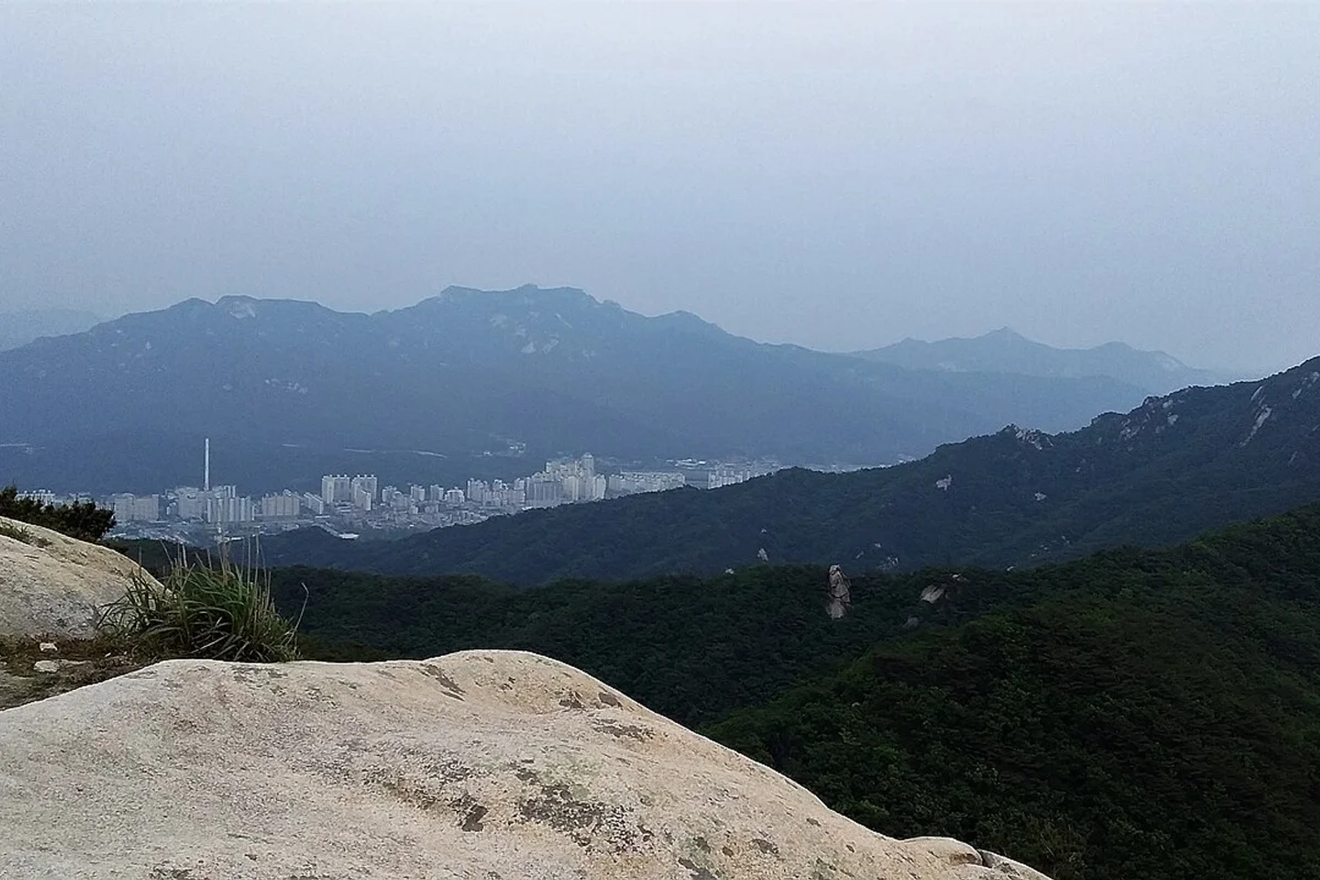
After exiting the Train Rock, the trail continues past Iron Helmet Rock (Cheolmobawi) and Descent Rock (Hagang Bawi) before reaching the main ridge and summit. Exposure decreases but technical sections continue. The summit view extends north to Bukhansan National Park and south across the full northern Seoul skyline.
Descent — Summit to Suraksan Station
The southern descent toward Suraksan Station is less technical than the ascent but still demands careful footing. Additional rock formations punctuate the ridge — Chimabawi (Skirt Rock) and Dosolbong offer brief pauses with views. Trekking poles are strongly recommended — five hours of sustained effort on the knees adds up, and the lower section enters the Suraksan Valley with stream crossings and rockier path. The Byeokun Valley, accessible near the base and reachable from Suraksan Station Exit 1 within 10 minutes, is known as a genuine mountain stream experience and is popular for summer valley walking.
Best for: Experienced hikers with previous rock scrambling, anyone wanting Seoul's most technical accessible summit.
Danggogae Route — Temple Approach
Starting from Danggogae Station (Line 4), this western approach passes through Hakrimsa Temple — "Crane Forest Temple" — and Cheonghak Valley (Crane Valley). The trail is less exposed than the Jangam route, crowds are noticeably lighter, and the cultural experience is more prominent. Hakrimsa connects to Yonggul-am (Dragon Cave Hermitage) along an established path, and the valley section with its stream and forest canopy is among the more pleasant approaches on any Seoul mountain.
This route can be combined with the main traverse by descending toward Suraksan Station after the summit, or hiked as a round trip via the same approach.
Best for: Intermediate hikers, those prioritizing temples and forest over technical scrambling, repeat visitors who have already done the main route.

Best for Most Travelers
If you have done Bukhansan's Baegundae and the Dobongsan Obong ridge and want more: Jangam to Suraksan Station traverse. Five to five and a half hours, the Gichabawi rope section, and a proper sense of accomplishment. Start at Jangam Station (Shinbundang Line, Exit 1) by 6 to 7am on weekends to beat the crowds at Train Rock.
If you want the mountain without the rope work: Danggogae route. The western approach through Hakrimsa Temple and Cheonghak Valley is less exposed, quieter, and still reaches the summit. Four to five hours, no near-vertical scrambling, and a genuine temple experience along the way.
If you are choosing between Suraksan and Dobongsan: Dobongsan's Obong traverse is more sustained ridge walking with broader views; Suraksan's Gichabawi is a single intense technical section. Dobongsan is the better overall ridge hike. Suraksan is the more concentrated challenge.
Who Should Do This Hike
Suraksan suits hikers who have already completed several Seoul mountain hikes and want more technical terrain. Previous comfort with fixed rope sections — at minimum the Bukhansan Baegundae summit ropes or the Dobongsan Obong traverse — is the right baseline preparation.
The mountain is not appropriate for beginners, anyone uncomfortable with heights, or visitors in casual footwear. Ankle-support hiking boots are essential on the technical sections. The route should not be attempted in rain, high wind, or icy conditions — the Gichabawi section becomes genuinely dangerous when wet.
Tips Before You Go
- Bring at least 2 liters of water. There are no vendors on the mountain and the technical sections require sustained physical effort.
- Gloves make a meaningful difference on the Gichabawi rope section, particularly on the descent when grip fatigue sets in.
- Start by 6 to 7am on weekends to avoid congestion at Gichabawi. Autumn weekend afternoons can create 30-minute queues at the rope section.
- In winter, crampons and microspikes are required. Ice on the Gichabawi ropes makes the section extremely dangerous and should only be attempted by experienced winter mountaineers.
- Trekking poles are strongly recommended for the descent — clip them to your pack for the technical ascent sections.
- The Surak Healing Forest, operated by Nowon-gu, is Seoul's first designated natural recreation forest — located in the Suraksan foothills, it offers forest bathing and accommodation for those wanting to extend the visit.
- Do not smoke on the trail. Suraksan has experienced significant fire incidents, including a 2026 blaze near Suamsa Temple that destroyed three buildings and 15,000 square meters of forest.
- Emergency number: 119.
How to Get There
From Jangam Station (Shinbundang Line, Exit 1 — main traverse start): Walk approximately 10 minutes toward the Jangam Valley trailhead following signs for Suraksan. Total travel time from central Seoul is approximately 35–45 minutes.
From Suraksan Station (Line 7, Exit 1 — descent end or reverse start): Walk approximately 10–15 minutes to the southern trailhead. Use this as your exit point on the main traverse, or as the starting point if hiking the route in reverse. The Byeokun Valley is accessible from this approach.
From Danggogae Station (Line 4 — western temple approach): Walk approximately 15–20 minutes toward Hakrimsa Temple and the Cheonghak Valley trailhead.
Use Naver Maps for real-time routing on the day.
Final Thoughts
Suraksan is the Seoul mountain for hikers who have already worked through the standard northern peaks and want something that demands more. The Gichabawi traverse is genuinely technical by Seoul standards — not rock climbing, but close enough that preparation matters. Get there early on autumn weekends, take your time on the ropes, and the descent through the valley back toward Suraksan Station is a satisfying way to finish.
The mountain carries more weight than its elevation suggests. A temple founded in 599 CE, renamed twice as dynasties shifted. A stone Maitreya at Naewon-am that may predate the Goryeo Dynasty. Three waterfalls whose names — Gold, Silver, Jade — belong to a tradition of scenic classification that scholars maintained for centuries. And Gichabawi itself, which earns its reputation not through altitude but through the honest question it poses: do you trust your grip, your balance, and your nerve enough to keep climbing?
If you're planning multiple hikes in Seoul, start with the full guide: Best hikes in Seoul — all mountains by difficulty and subway access
Related Guides
Explore more hiking in Seoul:
- Best hikes in Seoul — full overview by difficulty and subway access
- Dobongsan Hiking Guide — technical ridge, comparable difficulty
- Bukhansan Baegundae Hiking Guide — Seoul's highest summit
FAQ
How difficult is Suraksan hiking? Suraksan is one of Seoul's most technically demanding day hikes. The main Jangam traverse involves fixed-rope rock scrambling on the Gichabawi section — a 20-meter near-vertical granite wall. Previous hiking experience and comfort with exposed rock are strongly recommended.
What is Gichabawi on Suraksan? Gichabawi (Train Rock) is a 20-meter vertical granite formation with a central groove resembling train tracks. It is the defining technical feature of the main Suraksan route, equipped with fixed metal cables. Most people who turn back on Suraksan do so here — not because it is technically impossible, but because the exposure is greater than expected.
How long does it take to hike Suraksan? The main Jangam to Suraksan Station traverse takes 5 to 5.5 hours. Budget additional time for the Gichabawi section on weekends — congestion can add 30 minutes or more at peak periods in autumn.
How do I get to Suraksan by subway? The main traverse starts from Jangam Station (Shinbundang Line, Exit 1) and ends at Suraksan Station (Line 7, Exit 1). Travel time from central Seoul is approximately 35 to 45 minutes to either station.
Is Suraksan safe for beginners? No. Suraksan's main route requires previous rock scrambling experience and comfort with exposed terrain. The Danggogae approach is more accessible for intermediate hikers. Beginners should start with Namsan, Inwangsan, or Achasan before attempting Suraksan.
What is the best season to hike Suraksan? Autumn (October to early November) is peak season — comfortable temperatures, clear visibility, and peak foliage color. Spring is a good alternative. Avoid summer afternoons due to thunderstorm risk. Winter is for experienced mountaineers only due to ice on the rope sections.
Continue exploring Korea's mountains
More routes, same honest field notes.
Related guides

Nearby hikes
EasyAchasan Hiking Guide: Han River Views and Sunrise
A practical guide to hiking Achasan in Seoul — the main summit route, the Achasan-Yongmasan ridge traverse, Han River sunrise views, and subway directions.

Nearby hikes
HardBukhansan Hiking Guide: Baegundae Summit in Seoul
A practical guide to hiking Bukhansan National Park in Seoul — Baegundae summit routes, Bukhansanseong Fortress, Insubong rock climbing, and subway access.

Nearby hikes
ModerateBulamsan Hiking Guide: Granite Ridge and Azaleas
A practical guide to hiking Bulamsan in northeast Seoul — the Sanggye route, Hwangangdae technical scramble, spring azaleas, and how to get there by subway.