Bulamsan Hiking Guide: Granite Ridge and Azaleas
A practical guide to hiking Bulamsan in northeast Seoul — the Sanggye route, Hwangangdae technical scramble, spring azaleas, and how to get there by subway.

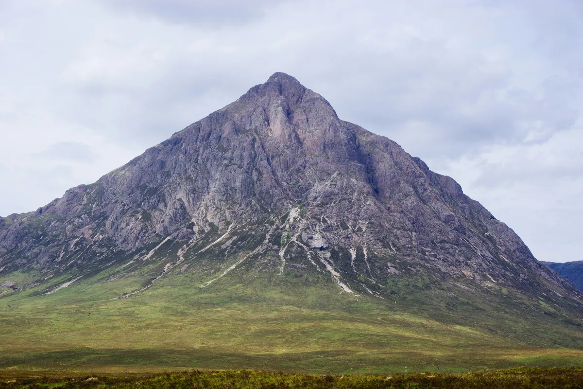
Bulamsan rises to 508 meters in northeast Seoul, on the boundary of Nowon-gu and Namyangju in Gyeonggi Province — one of the key hiking mountains in the city. The summit is a single massive granite dome — visible from across the district and shaped, according to local tradition, like a Buddha wearing a monk's peaked hat. The name means "Buddha Rock Mountain," and the geology earns it. Thirteen separate granite domes form the mountain's structure, with erosion grooves found nowhere else among Seoul's peaks.
The mountain sits directly across Deokneung Pass from Suraksan, and the two are commonly linked as a ridge traverse. But Bulamsan on its own is a focused half-day hike: granite scrambling, rope-assisted sections on the upper ridge, and a summit panorama that takes in central Seoul, N Seoul Tower, and Lotte World Tower on clear days.
In late April and early May, roughly 100,000 azalea bushes bloom across the ridge. The timing is narrow — about ten days of peak color — and it is the single best reason to prioritize Bulamsan over nearby alternatives during spring.
For visitors searching for a Bulamsan Seoul hike with granite scrambling and short access from the city, this mountain offers one of the most efficient summit experiences in the capital.
Quick Info
Quick summary for planning your Bulamsan hike at a glance.
- Location: Nowon-gu, Seoul / Namyangju, Gyeonggi Province border, South Korea
- Highest Point: 508m
- Difficulty: Easy–Moderate to Moderate–Hard (route-dependent)
- Best Time to Visit: Late April–May (azalea bloom), October–November (autumn)
- Entrance Fee: Free
- Nearest Station: Sanggye Station (Line 4) or Hagye Station / Suraksan Station (Line 7)
- Travel Time from Central Seoul: 45–60 minutes
Trail Overview
| Trail | Distance | Time | Difficulty | Best For |
|---|---|---|---|---|
| Sanggye Route | 2.6km one-way | 1.5–2h up | Easy–Moderate | First-timers, families, quick summit |
| Hwangangdae Route | 5.8km one-way | 2.5–3h up | Moderate–Hard | Technical scrambling, temple visit |
| Deokneung Pass Route | 8–10km traverse | 2.5–3.5h | Moderate | Quieter approach, temple network |
| Bulamsan–Suraksan Traverse | ~8km ridge | 4.5–5.5h | Moderate–Hard | Full ridge experience, experienced hikers |
Why Bulamsan Is Worth It
Bulamsan does not appear on most Seoul hiking lists aimed at foreign visitors. Bukhansan and Dobongsan take those slots. But Bulamsan is the primary hiking mountain for Nowon-gu residents, and for anyone staying in northeast Seoul — Nowon, Jungnang, or the Line 4 corridor — it is the most direct granite ridge experience available. The azalea bloom in late April is unmatched by any other mountain in the city.
The geology is distinctive. The 160-million-year-old Jurassic granite here formed differently from the rock at Bukhansan or Dobongsan, producing groove-shaped erosion patterns on the summit dome that are unique to this mountain. The result is a rougher, more textured scrambling experience on the upper sections — less polished staircase, more hands-on rock.
The Buddhist heritage is layered throughout. Bulamsa Temple at the southern base dates to 824 CE. Hakdoam, partway up the Hwangangdae route, houses a 22.7-meter rock-carved Avalokitesvara Bodhisattva commissioned in 1872 by Empress Myeongseong — one of the finest cliff carvings from late Joseon.
For comparison, Dobongsan offers more dramatic granite ridgelines with higher technical demands. Suraksan is the natural continuation if you want a full-day traverse. Achasan is the easier alternative if Bulamsan's rope sections sound like too much.
For a full overview of Seoul's hiking options by difficulty and subway access, see the complete Seoul hiking guide.
Difficulty and Time Required
The gap between routes matters here. The Sanggye approach is short and direct — 2.6 kilometers one-way with rope-assisted sections only in the final 800 meters. Most people in reasonable fitness complete the round trip in 3 to 3.5 hours. The Hwangangdae route is nearly twice the distance and includes Kalkdiggogae, a steep rock pass that involves sustained rope-assisted climbing over roughly 500 meters of trail. That section is where most people reassess their ambitions.
There are no fixed metal stairs or railings on the upper ridge — only rope handholds bolted into granite. The exposure is real but manageable with care. Wet conditions make the rock genuinely dangerous. Do not attempt the summit sections after rain.
Trail Options
Sanggye Route — Most Popular
The Sanggye approach is the standard Bulamsan experience. From Sanggye Station (Line 4, Exit 1), walk 15 to 20 minutes through the Sanggye-dong residential area to the trailhead. The path climbs through forest, passes Jeongamsa Temple, and joins the main ridge before the final granite scramble to the summit.
Lower section — Residential area to forest
The first kilometer passes through Sanggye-dong neighborhoods with clear signage. The gradient is gentle and the trail is wide. Water fountains are available in the residential section — fill up here, as there are no water sources on the mountain.
Mid section — Forest to ridge junction
The trail steepens through mixed pine and oak forest. The canopy provides shade through this section, and the path is well-maintained packed earth. Jeongamsa Temple marks the transition from forest climbing to ridge hiking.
Upper section — Ridge scramble to summit
The final 800 meters involve rope-assisted granite scrambling. The rock is rough-textured and provides good grip in dry conditions, but the angle is steep enough that hands are necessary throughout. The summit dome itself requires careful foot placement on exposed granite with drop-offs on the eastern side.
From the top, the view covers central Seoul to the southwest — N Seoul Tower and Lotte World Tower are both clearly visible on clear days — and Suraksan rises directly across Deokneung Pass to the north.
Round trip: approximately 3 to 3.5 hours. Suitable for adults and teenagers in reasonable fitness with proper footwear.
Best for: First-time visitors to Bulamsan, anyone wanting a direct summit experience, morning hikes from northeast Seoul.
Hwangangdae Route — Technical Challenge
The Hwangangdae approach from the Line 7 corridor is the longer, harder alternative. From Hagye Station (Line 7, Exit 1), walk 15 to 20 minutes toward the trailhead near the rear gate of the Korea Cancer Center Hospital. The route passes through forest, reaches the Hakdoam temple junction, then climbs the infamous Kalkdiggogae steep pass before joining the main ridge to the summit.
Lower section — Hospital area to Samyuk University junction
The first 2.5 kilometers follow a gradual forest trail through the urban-rural transition. The path is well-marked and shaded. This section is suitable for all fitness levels.
Mid section — Hakdoam junction
At the Hakdoam junction, a short detour reaches the temple and its 22.7-meter rock-carved Bodhisattva — Seoul Tangible Cultural Property No. 124, carved directly into the cliff face in 1872. The scale is striking and worth the 10-minute side trip.
Upper section — Kalkdiggogae
The name translates roughly as "gasp-for-breath pass." Over approximately 500 meters of horizontal distance, the trail gains around 80 meters of elevation through rope-assisted rock climbing on exposed granite. This is where the route earns its difficulty rating. The section is not suitable for anyone uncomfortable with heights or sustained physical effort on rock.
The granite here holds heat in summer — the exposed upper sections can be punishing from midday onward. Start early.
Round trip: approximately 5 to 6 hours. Requires confidence on rope-assisted rock sections.
Best for: Experienced hikers, those wanting the full Bulamsan challenge, anyone interested in the Hakdoam temple detour.
Deokneung Pass Route — Quieter Alternative
The Namyangju approach from the southeast passes through Bulamsa Temple (founded 824 CE) and Seokcheon-am before climbing to the summit and descending via Deokneung Pass toward Sanggye. This 8 to 10 kilometer traverse covers the mountain's Buddhist heritage sites and provides a less crowded experience than the Sanggye route.
Bulamsa Temple holds Treasure No. 591 — a set of Buddhist woodblock prints of significant historical value. Seokcheon-am, higher on the mountain, houses a rock-carved Maitreya Buddha created in 1966.
This route connects naturally to the Suraksan traverse for anyone planning to continue north.
Best for: Those seeking quieter trails, Buddhist heritage interest, anyone combining with the Suraksan traverse.
Bulamsan–Suraksan Traverse — Full Ridge Experience
The traverse follows the ridge north from Bulamsan's summit to Deokneung Pass (approximately 2 kilometers, 40 minutes), then continues to Suraksan's summit at 638 meters (approximately 3.5 kilometers, 1.5 hours). The total ridge distance is roughly 5.5 kilometers with 2 to 2.5 hours of hiking time between summits.
This traverse forms part of the greater Gangbuk Five Mountains ridge route (Bulamsan–Suraksan–Sapaesan–Dobongsan–Bukhansan) and overlaps with Seoul Dulle-gil Course 3. The exposed ridge sections offer continuous panoramic views but no shelter or water sources between the two summits.
Carry at least 3 liters of water. Start before 7am to allow sufficient daylight. Do not attempt the traverse if thunderstorms are forecast — the exposed ridge offers no protection from lightning.
Best for: Experienced hikers with a full day, those connecting to Suraksan, ridge traverse enthusiasts.
Best for Most Travelers
If you want a focused granite summit experience without a full-day commitment, the Sanggye route is the best choice on Bulamsan. The 2.6-kilometer trail from Sanggye Station reaches the summit in 1.5 to 2 hours, with rope-assisted scrambling only in the final 800 meters. The round trip takes 3 to 3.5 hours, and the summit view covers central Seoul, N Seoul Tower, and Lotte World Tower on clear days.
During azalea season (late April to early May), the Sanggye route also passes the upper ridge where roughly 100,000 azalea bushes bloom — making it the best single hike in Seoul for spring wildflowers.
For hikers wanting more challenge, the Hwangangdae route from Hagye Station adds the Hakdoam temple detour and the Kalkdiggogae steep pass, but requires 5 to 6 hours and confidence on exposed rock.
Who Should Do This Hike
Bulamsan suits hikers looking for granite scrambling and ridge exposure without the crowds and commute time of Bukhansan. The Sanggye route is appropriate for any adult in moderate fitness with proper footwear — the rope sections are brief and well-equipped. The Hwangangdae route and the Suraksan traverse are for hikers comfortable with sustained effort on exposed rock.
The mountain is not suitable for young children on the upper sections. The rope-assisted scrambling requires hand strength and confidence on steep terrain. Families with children under 10 should plan to turn back at the forest-to-ridge transition on the Sanggye route.
During azalea season (late April to early May), the ridge trails become significantly more crowded. Arrive before 8am on weekends during bloom to have the upper sections to yourself.
Tips Before You Go
- There are no water sources on the mountain. Carry everything from the start — 2 liters minimum for the Sanggye route, 3 liters for the Hwangangdae route or traverse.
- The granite becomes dangerously slippery when wet. Avoid the upper ridge sections after rain.
- Hiking boots with ankle support are essential for the rope-assisted sections. Trail runners are insufficient for the upper scrambling.
- In winter, crampons are required for the ridge sections. Ice forms on the granite and the rope sections become extremely hazardous.
- Azalea bloom peaks from approximately April 25 to May 5. The flowers are protected — stay on marked trails and do not pick them.
- Emergency number: 119. Location signs are posted at major junctions — provide the sign code when calling.
How to Get There
From Sanggye Station (Line 4, Exit 1 — main approach): Walk 15 to 20 minutes north through Sanggye-dong residential area to the trailhead. From central Seoul (Myeongdong, Gangnam), total travel time is approximately 45 to 60 minutes by subway.
From Hagye Station (Line 7, Exit 1 — technical route): Walk 15 to 20 minutes toward the Korea Cancer Center Hospital rear gate area. The trailhead is clearly signed from the station.
From Danggogae Station (Line 4 — alternative): Walk 20 to 25 minutes to the main trailhead. Less crowded starting point than Sanggye Station.
Use Naver Maps for real-time routing on the day.
Final Thoughts
Bulamsan is the granite mountain that northeast Seoul residents know and visitors rarely find. The Sanggye route delivers a proper summit scramble in under two hours from the trailhead, and the view from the top — the entire Seoul basin laid out to the southwest, Suraksan rising across the pass to the north — is one of the better summit payoffs for the effort required.
If you are visiting Seoul in late April or early May, the azalea bloom alone justifies the trip. One hundred thousand bushes across the upper ridge, roughly ten days of peak color, and a granite backdrop that photographs well in any light. If you want to extend this into a full-day ridge hike, continue to Suraksan via Deokneung Pass — the two mountains connect naturally and the combined traverse is one of the best ridge routes in Seoul.
If you're planning multiple hikes in Seoul, start with the full guide: Best hikes in Seoul — all mountains by difficulty and subway access
Related Guides
Explore more hiking in Seoul:
- Best hikes in Seoul — full overview by difficulty and subway access
- Suraksan Hiking Guide — connected via Deokneung Pass
- Dobongsan Hiking Trail — granite ridge north of Seoul
FAQ
Is Bulamsan a good hike for beginners? The Sanggye route is suitable for beginners in reasonable fitness. The lower sections are well-maintained forest trail, though the final 800 meters involve rope-assisted granite scrambling. Total round trip takes 3 to 3.5 hours.
How do I get to Bulamsan from central Seoul? Take Seoul Metro Line 4 to Sanggye Station (Exit 1) and walk 15 to 20 minutes north to the trailhead. Total travel time from central Seoul is approximately 45 to 60 minutes.
When is the best time to see azaleas on Bulamsan? The azalea bloom peaks from approximately April 25 to May 5 each year. Roughly 100,000 azalea bushes flower across the upper ridge and Azalea Hill. Arrive before 8am on weekends to avoid crowds during peak bloom.
How long does it take to hike Bulamsan? The Sanggye route takes 3 to 3.5 hours round trip. The Hwangangdae route takes 5 to 6 hours. The full Bulamsan–Suraksan traverse takes 4.5 to 5.5 hours one-way.
Can I connect Bulamsan to Suraksan? Yes. The ridge traverse from Bulamsan summit crosses Deokneung Pass and continues to Suraksan summit (638m). Total distance is approximately 8 kilometers, requiring 4.5 to 5.5 hours. Start before 7am and carry at least 3 liters of water.
What should I bring for hiking Bulamsan? Hiking boots with ankle support are essential. Carry at least 2 liters of water — there are no water sources on the mountain. Bring sun protection, a windbreaker for the exposed ridge, and gloves for the rope-assisted sections.
Continue exploring Korea's mountains
More routes, same honest field notes.
Related guides

Nearby hikes
ModerateCheonggyesan Hiking Guide: Routes and Waterfalls
A practical guide to hiking Cheonggyesan near Seoul — the Wonteogol valley route, ridge traverse to 618m, hidden waterfalls, and subway access from Gangnam.

Nearby hikes
EasyAchasan Hiking Guide: Han River Views and Sunrise
A practical guide to hiking Achasan in Seoul — the main summit route, the Achasan-Yongmasan ridge traverse, Han River sunrise views, and subway directions.

Nearby hikes
HardBukhansan Hiking Guide: Baegundae Summit in Seoul
A practical guide to hiking Bukhansan National Park in Seoul — Baegundae summit routes, Bukhansanseong Fortress, Insubong rock climbing, and subway access.