Gwanaksan Hiking Guide: Routes and Tips for Seoul
A practical guide to hiking Gwanaksan in Seoul — four trail routes to the 632m summit, the cliffside Yeonjuam Hermitage, and how to get there by subway easily.

Gwanaksan sits on the southern edge of Seoul at 632 meters. The mountain draws roughly five million visitors a year — more than most national parks — yet it feels noticeably less crowded than Bukhansan on the same weekend. That is partly geography: the trail network spreads across multiple entry points from Seoul, Gwacheon, and Anyang, so the load distributes more evenly. Compared to Bukhansan National Park, which dominates northern Seoul, Gwanaksan represents the best hiking option in the south of the city.
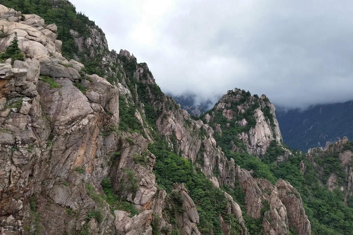
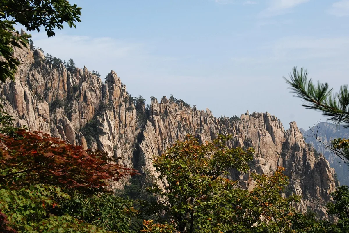
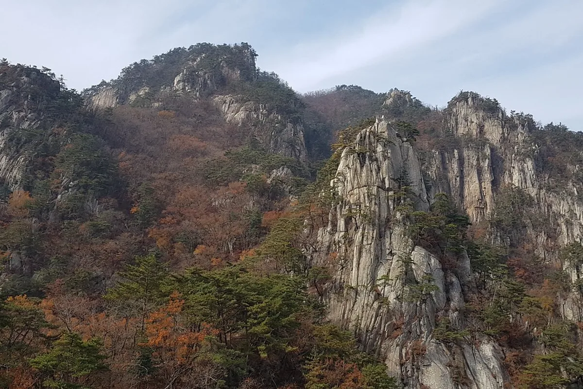
The mountain's name means "hat-shaped peak" — the character 冠 (gwan) refers to the traditional Korean gat, and the summit profile does resemble a pointed cap when viewed from the south. Geologically, Gwanaksan is composed of Jurassic-era Daebo granite (approximately 160 million years old), primarily biotite granite with some granodiorite, which intruded into an older base of banded biotite gneiss. Weathering and erosion of this granite have produced dozens of distinctive tors — rounded granite boulder formations — across the upper ridgeline, giving the mountain its characteristic rocky profile and making it one of Seoul's most representative granite landscapes.
The cultural layer here is distinctive. Yeonjuam Hermitage, built into the cliffside at approximately 629 meters, was originally founded in 677 CE by the Silla monk Uisang and has been an active Buddhist site for over 1,300 years. The name "Yeonjudae" — the lookout point at the summit — means "longing for the lord": after the fall of the Goryeo dynasty, loyalists including Gang Deung-ryong climbed to this point to gaze north toward the old capital Songdo and weep for their fallen kingdom. In Joseon-era geomancy, Gwanaksan was believed to emit powerful "fire energy" (hwagi) that threatened the royal palace — the haetae guardian statues at Gwanghwamun Gate were placed facing south specifically to suppress the mountain's fiery influence.
What makes Gwanaksan worth the trip from elsewhere in the city is the combination of genuine terrain and southern Seoul views. The ridge routes involve real rock, steep stair sections, and a cliffside Buddhist hermitage carved into the granite face. The summit looks north across the full span of the city — a different angle from what you get at Bukhansan or Dobongsan.
Quick Info
Quick summary for planning your Gwanaksan hike at a glance.
- Location: Gwanak-gu, Seoul / Gwacheon, Gyeonggi Province, South Korea
- Highest Peak: Gwanaksanbong, 632m
- Difficulty: Easy to Hard depending on route
- Best Time to Visit: April–June (spring), October–November (autumn)
- Entrance Fee: Free
- Park Hours: No formal closure — daylight hours recommended
- Nearest Stations: Seoul National University (Line 2), Sadang (Line 2/4), Gwacheon (Line 4)
Trail Overview
| Trail | Distance | Elevation Gain | Time | Difficulty | Best For |
|---|---|---|---|---|---|
| SNU Entrance Route | 2.1km one-way | +420m | 1–1.5h up | Easy | Beginners, first visit |
| Gwacheon Sacred Site Route | 3.2km one-way | +380m | 1.5h up | Easy–Medium | Families, valley scenery |
| Sadang Ridge Route | 9.4km total | +600m cumulative | 5–5.5h | Hard | Ridge hikers, long day |
| Anyang Eight-Peak Route | 3.6km | +450m | ~3h | Medium | Fewer crowds, springs |
Why Gwanaksan Is Worth It from Southern Seoul
Most visitors to Seoul head north for Bukhansan. That is the right call for a first hike — but Gwanaksan is the better option if you are staying in Gangnam, Seocho, or Gwanak-gu, or if you want to avoid the lines that form on Bukhansan's fixed rope sections on autumn weekends. For hiking in Seoul's southern half, this is the default answer.
The cultural layer here is different too. Yeonjuam Hermitage, a small Buddhist temple cut directly into the cliffside near the summit, is one of the more atmospheric spots on any Seoul hiking trail. The Gwacheon Sacred Site route passes Gwacheon Hyanggyo, a Joseon-era Confucian shrine, before entering the forest and following the Jaha Dongcheon waterfall section upward through the valley. Neither is typical of what you find on the northern mountains.
The ecology reflects the granite environment. The summit area has thin, nutrient-poor soil supporting Korean red pine as the dominant species, with azalea and rhododendron blooming in early spring. The mountain supports 11 Korean endemic plant species, 4 rare plant species, and approximately 40 species requiring conservation attention. A total of 41 bird species have been documented. The Gwanaksan Ecological Park, opened in December 2007 near Miseongdong, covers 76,521 square meters and includes both a forest restoration zone in the upper section and an ecological pond zone in the lower section, where frogs, woodpeckers, and squirrels can be observed.
Compared to Dobongsan, which is technically harder and farther north, Gwanaksan has more route variety and a wider range of entry points. It suits an afternoon hike from southern Seoul in a way that the northern mountains simply do not.
Difficulty and Time Required
The SNU route is the most forgiving introduction to Gwanaksan — the forest path is wide and well-maintained until the final steep section known locally as "kkaldak-gogae," a 30-degree slope that takes about 20 minutes with rope handholds available for assistance. Most people in reasonable fitness handle it without difficulty. The total elevation gain of 420 meters is spread across 2.1 kilometers, with the first 1.5 kilometers at a gentle gradient through deciduous forest.
The Gwacheon Sacred Site route is slightly longer at 3.2 kilometers with 380 meters of elevation gain. The valley approach is gentler overall, but the final section to Yeonjuam Hermitage and onward to the summit involves steep steps. The stream-side walking through the Jaha Dongcheon section provides natural cooling in summer.
The Sadang Ridge is a different category. Nine kilometers with over 600 meters of cumulative elevation change, exposed ridge sections, and several steep drops makes it one of the more demanding full-day hikes in Seoul. The route traverses multiple named landmarks — Hamaba Rock, Madang Rock, Gwanaksan Gate, and Flag Peak — with rock scrambling between each. It is not technical, but it demands stamina and proper footwear. Do not start it in the afternoon.
Trail Options
SNU Entrance Route — Most Popular
The shortest route to the summit starts from a bus stop near Seoul National University, about 15 minutes by bus from Seoul National University Station (Line 2, Exit 3). The trail follows a forested path for 1.5 kilometers before the gradient increases sharply at kkaldak-gogae. The final push opens onto rocky outcrops with the first expansive views of Seoul.
Round trip takes approximately 3 hours including rest time. Families with older children manage this route comfortably. The path is shaded for most of its length, which matters significantly in summer.
Best for: First-time visitors, half-day hikes, anyone based in southern or western Seoul.
Gwacheon Sacred Site Route — Best for Scenery
This approach begins at Gwacheon Hyanggyo, a Joseon-era Confucian shrine accessible from Gwacheon Station (Line 4, Exit 1) by taxi or local bus. The trail follows a valley stream upward through dense forest, passing mineral spring water points and a waterfall section called Jaha Dongcheon before reaching Yeonjuam Hermitage near the summit.
The hermitage itself — built into the granite cliff face at around 600 meters — is worth the route on its own. The approach through the valley is quieter and more visually varied than the SNU route. Round trip takes approximately 3 to 4 hours.
Best for: Visitors coming from Gwacheon, those who want a cultural element, families looking for water features and shade.
Sadang Ridge Route — Best for Ridge Hikers
The Sadang approach covers 9.4 kilometers in total and takes approximately 5 to 5.5 hours. It begins near Sadang Station (Line 2/4) and follows the mountain's main ridge toward the summit before descending via a different route. The ridge sections involve sustained steep climbing, occasional scrambling, and open exposure with views in both directions.
This is the route that puts Gwanaksan in a different category from the other Seoul mountain day hikes. The views from the ridge take in both the southern Han River side and the northern Seoul skyline simultaneously on clear days. Popular for hiking in Seoul among experienced hikers who want a full-day challenge without leaving the city.
Trekking poles help significantly on the descent. Do not underestimate the length — five hours of active hiking with full elevation change is a serious commitment.
Best for: Experienced hikers wanting a full-day challenge, ridge walking enthusiasts.
Anyang Eight-Peak Route — Fewest Crowds
This approach from the Anyang side covers 3.6 kilometers with 450 meters of elevation gain and takes around 3 hours to the summit. Starting near Gwanyang High School, accessible from Indeokwon Station (Line 4), the trail passes through forest before reaching two well-maintained mineral spring water points — Ganchon Spring and Gwangsang Spring — both popular social gathering spots for regular hikers. The route then traverses the "eight peaks" (palbong), a series of smaller summits along the ridge that provide continuous views toward Anyang and Gwacheon before joining the main summit approach.
Weekend crowds are noticeably lighter here than on the Seoul-side trails, and the abundant spring water sources make this a practical option for hikers who prefer not to carry heavy water supplies.
Best for: Those who prefer quieter trails, visitors coming from Anyang or Gwacheon, hikers who value spring water access along the route.
Best for Most Travelers
For a first visit to Gwanaksan, the SNU Entrance Route is the most straightforward option. At 2.1 kilometers one-way with 420 meters of elevation gain, it reaches the summit in about 1 to 1.5 hours on a well-maintained forest trail. The path is shaded for most of its length — a significant advantage in summer — and the only genuinely steep section is the kkaldak-gogae slope near the top, a 30-degree pitch that takes about 20 minutes. Round trip including rest time is approximately 3 hours.
For visitors who want more scenery and cultural depth, the Gwacheon Sacred Site Route is the stronger choice. It begins at Gwacheon Hyanggyo, follows a valley stream upward through forest and past mineral spring water points, passes the Jaha Dongcheon waterfall section, and reaches Yeonjuam Hermitage — a Buddhist temple built into the granite cliff face at around 600 meters — before the final push to the summit. The round trip takes 3 to 4 hours. This route combines natural water features, cultural heritage, and the summit view in a single half-day hike that the SNU route does not match for variety.
Who Should Do This Hike
Gwanaksan works for a wider range of fitness levels than most Seoul mountains because of its trail variety. The SNU and Gwacheon routes are genuinely accessible to beginners with proper footwear. The Sadang Ridge is for experienced hikers only.
The mountain is not suitable for casual footwear on any route above the forest section. Rocky steps and exposed granite near the summit become slippery after rain. Winter hiking is possible but requires crampons on the kkaldak-gogae section and the upper ridge.
Tips Before You Go
- Bring at least 1.5 liters of water — 2 liters or more for the Sadang Ridge. The Gwacheon route has mineral spring water points (check posted quality signs before drinking), but they are not guaranteed to be flowing in dry seasons. There are no water vendors on the mountain itself.
- Hiking boots are essential for any route beyond the initial forest section. The granite near the summit becomes slippery after rain, and the Sadang Ridge involves sustained rock scrambling where ankle support matters.
- Start before 8:00am on weekends in October — the summit area fills quickly during peak foliage season. On peak autumn weekends, Gwanaksan can see over 10,000 hikers in a single day.
- Yeonjuam Hermitage near the summit is an active Buddhist site. Remove shoes when entering temple buildings, keep voices low, and ask permission before close-up photography. The hermitage is a Jogye Order temple founded in 677 CE and holds deep spiritual significance.
- The Gwacheon route spring water points include the First Spring (je-1 yaksu), Second Spring (je-2 yaksu), and Samgeori Spring. Check the water quality certification sign posted at each location before drinking.
- In winter, crampons are recommended for the kkaldak-gogae section on the SNU route, the upper Gwacheon approach, and all sections of the Sadang Ridge. Icy granite is extremely hazardous.
- Gwanaksan Ecological Park (opened December 2007, 76,521 square meters) near Miseongdong provides a flat nature walk through both forest restoration and ecological pond zones. It is accessible separately from the hiking trails and suitable for families with young children.
- No formal seasonal closures apply to Gwanaksan, but typhoon-season weather warnings (August to September) can make ridge sections unsafe. Check conditions before going. Lightning on the exposed Sadang Ridge is a serious hazard during summer afternoon thunderstorms — plan to be off the ridge by early afternoon.
- Trekking poles help significantly on the Sadang Ridge descent. Five hours of active hiking with full elevation change is a serious commitment — do not start the Sadang route in the afternoon.
- Emergency number: 119. Provide your location using trail markers or distinctive landmarks (Madang Rock, Robot Rock, Yeonjuam) for fastest response. Cell service is generally available on ridges but may be weak in valley sections.
How to Get There
SNU Route: Seoul National University Station, Line 2, Exit 3. Take Bus 5511, 5513, or 5516 toward Seoul National University. Get off at the Construction and Environmental Research Institute stop. Total time from central Seoul approximately 30–40 minutes.
Gwacheon Route: Gwacheon Station, Line 4, Exit 1. Take a taxi or local bus to Gwacheon Hyanggyo (approximately 10 minutes). Total time from central Seoul approximately 40–50 minutes.
Sadang Route: Sadang Station, Line 2 or 4. Follow signage from the station exit to the trailhead — no bus required. Total time from central Seoul approximately 25–35 minutes.
Use Naver Maps or Google Maps for real-time transit directions on the day.
Final Thoughts
If you have already done Bukhansan and want a different side of Seoul's mountain landscape, Gwanaksan is the natural next step. The Gwacheon Sacred Site route combined with a visit to Yeonjuam Hermitage offers something the northern mountains do not — a trail that moves through both cultural history and serious terrain in the same afternoon.
For a longer challenge, the Sadang Ridge is one of the better full-day ridge hikes available within Seoul's city boundary without needing to travel to Gangwon Province.
If you are planning multiple hikes across the city, start with the full overview: Best hikes in Seoul — all mountains by difficulty and subway access
Related Guides
Explore more hiking in Seoul:
- Best hikes in Seoul — full overview by difficulty and subway access
- Bukhansan Baegundae Hiking Guide — Seoul's highest summit
- Dobongsan Hiking Trail — granite ridge north of Seoul
FAQ
How difficult is Gwanaksan hiking? Gwanaksan has four distinct routes ranging from easy to hard. The Seoul National University route is beginner-friendly with one steep section near the top. The Sadang Ridge route is a serious 9.4-kilometer trail suitable only for experienced hikers.
What is the best route to hike Gwanaksan for first-timers? The SNU Entrance Route is the most accessible starting point — 2.1 kilometers one-way, mostly forested, with one steep section called kkaldak-gogae near the summit. Allow 3 hours round trip.
How do I get to Gwanaksan by subway? The most direct access is Seoul National University Station on Line 2 (Exit 3), followed by a short bus ride. Sadang Station (Line 2/4) gives direct trailhead access without a bus. From central Seoul, allow 30 to 50 minutes depending on your starting point.
What is the best time to hike Gwanaksan? October is peak season for autumn foliage and clear skies. April and May are excellent for spring wildflowers. Avoid peak hours (10am to 3pm) on autumn weekends — the summit area becomes crowded.
Is Gwanaksan suitable for families with children? The SNU and Gwacheon routes are manageable for families with older children (10+) in proper footwear. The Sadang Ridge is not recommended for children. Bring sufficient water as there are no vendors on the mountain.
What is Yeonjuam Hermitage on Gwanaksan? Yeonjuam is a small Buddhist hermitage built into the granite cliff face near Gwanaksan's summit. It has been active for over 1,300 years and is one of the more striking landmarks on the mountain. It is accessible via the Gwacheon Sacred Site route.
Continue exploring Korea's mountains
More routes, same honest field notes.
Related guides

Nearby hikes
EasyAchasan Hiking Guide: Han River Views and Sunrise
A practical guide to hiking Achasan in Seoul — the main summit route, the Achasan-Yongmasan ridge traverse, Han River sunrise views, and subway directions.

Nearby hikes
HardBukhansan Hiking Guide: Baegundae Summit in Seoul
A practical guide to hiking Bukhansan National Park in Seoul — Baegundae summit routes, Bukhansanseong Fortress, Insubong rock climbing, and subway access.

Nearby hikes
ModerateBulamsan Hiking Guide: Granite Ridge and Azaleas
A practical guide to hiking Bulamsan in northeast Seoul — the Sanggye route, Hwangangdae technical scramble, spring azaleas, and how to get there by subway.