Inwangsan Hiking Guide: Easy Hike Near Gyeongbokgung
A practical guide to hiking Inwangsan in Seoul — the Sajik Park route, Seoul City Wall trail, Seonbawi Rock, and how to get there by subway from the palace.

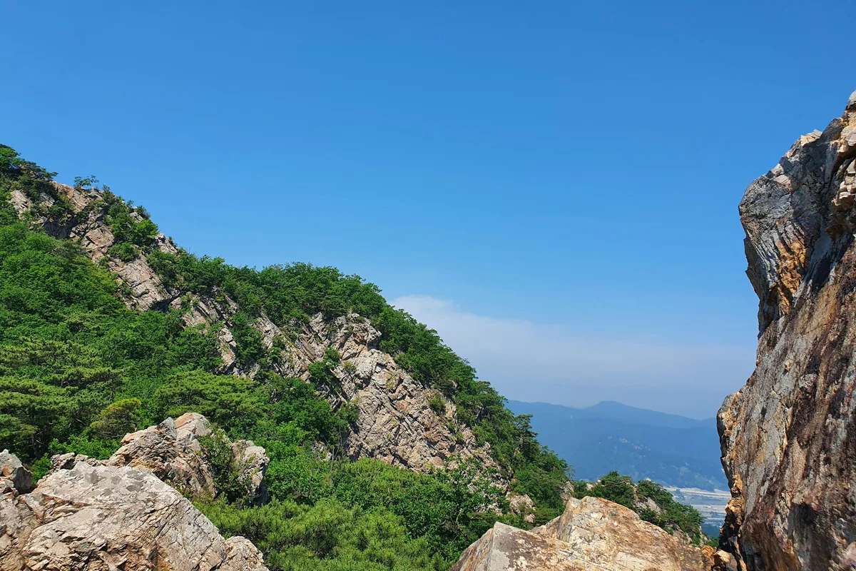
Inwangsan is 338 meters tall and sits five minutes from Gyeongbokgung Palace by foot. It is the best easy hike in Seoul — short enough to combine with a morning at the palace, varied enough to hold the attention of anyone who has already done the bigger northern peaks. The trail passes a 600-year-old city wall, a sacred shamanic shrine, and distinctive granite formations before reaching a summit with an unobstructed view across central Seoul, making it one of the most accessible options for hiking in Seoul.
The mountain was closed to the public for most of the 20th century as a restricted military zone. Reopened in 1993, it remains one of the least-visited major peaks in Seoul relative to its proximity to the city center — which means quieter trails even on autumn weekends.
Quick Info
Quick summary for planning your Inwangsan hike at a glance.
- Location: Jongno-gu / Seodaemun-gu, Seoul, South Korea
- Highest Point: 338m
- Difficulty: Easy to Medium (route-dependent)
- Best Time to Visit: Year-round — particularly good at sunset and for evening hikes
- Entrance Fee: Free
- Nearest Station: Gyeongbokgung Station (Line 3, Exit 2) or Dongnimmun Station (Line 3)
- UNESCO Connection: Part of Seoul City Wall (on the UNESCO World Heritage Tentative List)
Trail Overview
| Trail | Distance | Time | Difficulty | Best For |
|---|---|---|---|---|
| Sajik Park Route | 2.1km one-way | 1–1.5h up | Easy–Medium | Most popular, direct summit |
| Dongnimmun Route | 2.5km one-way | 1.5h up | Easy | Quieter western approach |
| Gichabawi Route | 1.3km one-way | 30 min | Easy | Shortest, rock formations |
| Suseongdong Valley | 1.5km | 1h | Easy | Shaded valley, stream |
| Fortress Wall Route | 4.0km | 2.5h | Medium–Hard | Full wall traverse, views |
| Combination Route | 3.5km | 2h | Medium | Best overall experience |
Why Inwangsan Is Worth It
Bukhansan and Dobongsan are the obvious choices for a serious day hike in Seoul. Inwangsan plays a different role — it is the mountain for visitors who want something more than a park walk but less than a full-day commitment. The best easy hike in Seoul for good reason: most routes reach the summit in under 90 minutes, and the trailhead is walkable from some of the city's most visited cultural sites.
The cultural density here is higher per kilometer than any other Seoul mountain. The Hanyangdoseong fortress wall — built in 1396 and running directly along the ridge — is on the UNESCO World Heritage Tentative List. Seonbawi Rock, a natural granite formation designated as Seoul's Intangible Cultural Property, has been a shamanist worship site for centuries and remains active today. The painter Jeong Seon used this mountain as the subject of "Inwang Jesaekdo" in 1751, now a National Treasure, which established the Korean tradition of painting authentic local landscapes rather than imitating Chinese styles.
For visitors based near Gyeongbokgung, Bukchon Hanok Village, or Seochon, the mountain is directly accessible on foot. No subway required.
For more challenging hikes, see Bukhansan National Park or Dobongsan.
Difficulty and Time Required
Inwangsan is the most accessible serious hike in central Seoul. The Sajik Park route involves stone staircases and some rocky sections near the top but nothing that requires scrambling or fixed ropes. Most people in any reasonable fitness level complete the round trip in under 2 hours.
The Fortress Wall route is a different experience — 4 kilometers with exposed sections and several steep climbs along the ridge. It is not technically difficult but demands more than the short summit routes and involves some exposure on narrow wall-top sections.
Trail Options
Sajik Park Route — Most Popular
Starting from Sajik Park (사직공원), this is the most direct and most used route to the Inwangsan summit. From Gyeongbokgung Station (Line 3, Exit 2), walk west along Jahamun-ro for about 15 minutes to the park entrance, then follow the marked trail upward.
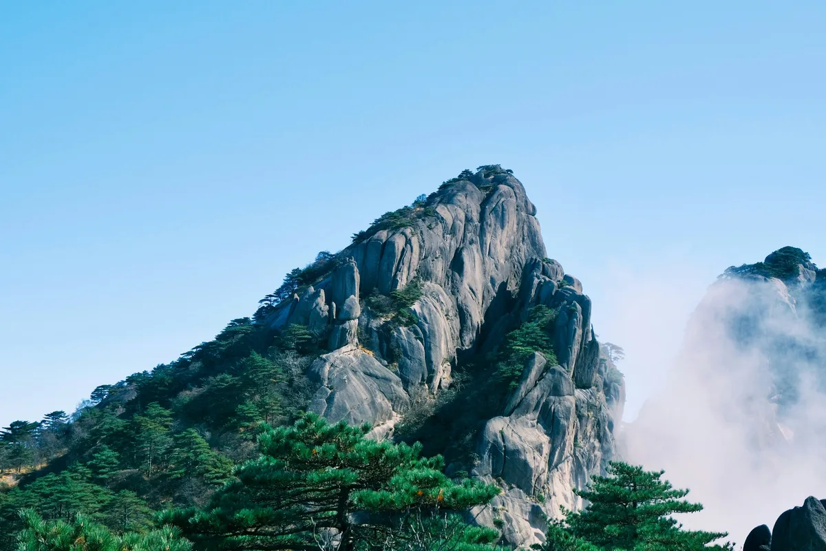
The path climbs steadily via stone staircases with handrails on the steeper sections. Along the way you pass Chimabawi (Skirt Rock), a distinctive granite formation, and several viewpoints looking down toward Gyeongbokgung Palace and the northern Seoul skyline. The summit area opens onto exposed granite with 360-degree views.
Round trip: approximately 1.5 to 2 hours. Best started in the late afternoon for sunset views.
Best for: First-time visitors, anyone combining with a Gyeongbokgung visit, sunset hikes.
Gichabawi Route — Shortest Option
The Gichabawi (Train Rock) route is the fastest way onto the mountain — 1.3 kilometers one-way and around 30 minutes to the distinctive rock formation that gives the route its name. The trail starts near Dongnimmun Station (Line 3) and passes through quieter residential streets before entering the forest.
Gichabawi itself is a long granite ridge that resembles a train from certain angles. The views from here are less panoramic than the summit but the route is excellent for a short morning visit before heading elsewhere in the city.
Best for: Time-limited visitors, those wanting a quick mountain fix without a full hike.
Suseongdong Valley Route — Quietest Option
The Suseongdong Valley trail follows a shaded stream through a narrow valley on the eastern slope of Inwangsan. It is less scenic than the summit routes but significantly quieter and entirely sheltered from sun — a worthwhile option in summer heat or for visitors who want a peaceful forest walk rather than a rocky climb.
The valley connects to both the Sajik Park and fortress wall routes, making it a useful approach for longer combination hikes.
Best for: Summer visits, quiet forest walking, combining with other routes.
Fortress Wall Route — Best Views
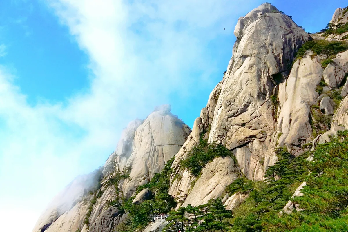
The full fortress wall traverse follows the Hanyangdoseong (Seoul City Wall) along Inwangsan's ridge for 4 kilometers. This is the most demanding route on the mountain but also the most rewarding for views — the wall-top path gives unobstructed sightlines in both directions, and the historical experience of walking a 600-year-old defensive wall above a modern capital is genuinely unusual.
The route involves several steep sections and some exposed narrow passages where the wall hugs the ridge edge. Allow 2.5 hours for the full traverse.
Best for: Those interested in history, second visits to Inwangsan, anyone who wants more than a summit run.
Cultural Highlights on the Trail
Seonbawi Rock — A pair of upright granite formations that have been a shamanic worship site since the Joseon Dynasty. The Guksadang Shrine nearby is an active place of worship and one of the few surviving shamanist sites in Seoul. Both are located on the approach to the summit from the Sajik Park side.
Hanyangdoseong (Seoul City Wall) — Built in 1396 as the defensive wall of the Joseon capital, the wall runs across Inwangsan's ridge and is on the UNESCO World Heritage Tentative List. The wall is best appreciated on the Fortress Wall route, where you walk on or directly beside it for most of the trail.
Jeong Seon's Inwang Jesaekdo — The painting that established Korea's tradition of depicting authentic local landscapes was made from observations of this mountain after a rainstorm in 1751. The designated viewpoint in the Suseongdong Valley area shows roughly what Jeong Seon would have seen. The original painting is National Treasure #216.
Best for Most Travelers
If you have two to three hours free and are staying near Gyeongbokgung or Seochon, the Sajik Park route is the best single option on Inwangsan. The 2.1-kilometer trail reaches the summit in about an hour, passes Chimabawi and Seonbawi Rock along the way, and finishes on exposed granite with a 360-degree view of central Seoul. Start in the late afternoon for sunset.
For visitors with more time, the combination route (Sajik Park up, fortress wall traverse, Dongnimmun descent) covers the summit, the Hanyangdoseong wall, and the cultural sites in roughly 2 to 2.5 hours — the most complete experience on the mountain.
Who Should Do This Hike
Inwangsan is the right choice for visitors who want a real Seoul mountain experience without the commitment of Bukhansan or Dobongsan. It is accessible to anyone in basic fitness with proper footwear. The short routes work for families with older children. The fortress wall route adds challenge for those who want more.
The mountain is not ideal for very young children on the exposed summit sections or the fortress wall traverse. Casual footwear is fine for the valley routes but not recommended for the rocky upper sections. Evening hiking is popular and well-established — the trail is used regularly after dark by locals, though a headlamp is useful on the less-lit sections.
Tips Before You Go
- Bring at least 1 liter of water. The routes are short but the granite sections get hot in summer.
- The summit and ridge sections face west, making Inwangsan one of Seoul's best sunset viewpoints. Plan accordingly.
- Do not photograph restricted military areas or installations near the ridge — signs are clearly posted.
- The trail is illuminated in the evening along the main sections, making it suitable for after-work hikes.
- Seonbawi Rock and Guksadang Shrine are active worship sites — be respectful and keep noise down in these areas.
- Emergency number: 119. Tourism hotline (English): 1330.
How to Get There
From Gyeongbokgung Station (Line 3, Exit 2 — main approach): Walk west along Jahamun-ro for approximately 15 minutes to Sajik Park. The trailhead is clearly marked at the park boundary. Total travel time from central Seoul is approximately 15–20 minutes.
From Dongnimmun Station (Line 3, Exit 3 — western approach): Walk east from the station for approximately 15–20 minutes to reach the Gichabawi trailhead. Use this entry for the shorter western routes.
Both stations are on Line 3. Use Naver Maps or Google Maps for real-time directions on the day.
Final Thoughts
Inwangsan works as a standalone hike and as a half-day addition to a Gyeongbokgung or Seochon visit. The combination of a short mountain trail, a UNESCO World Heritage candidate fortress wall, and active cultural sites in under two hours is something you will not find at any other Seoul mountain.
For visitors who want to extend the day, the Seochon hanok village at the base of the mountain is one of Seoul's better preserved traditional neighborhoods — a natural finish to a morning on the ridge.
If you're planning multiple hikes in Seoul, start with the full guide: Best hikes in Seoul — all mountains by difficulty and subway access
Related Guides
Explore more hiking in Seoul:
- Best hikes in Seoul — full overview by difficulty and subway access
- Bukhansan Baegundae Hiking Guide — Seoul's highest summit
- Dobongsan Hiking Guide — technical ridge north of Seoul
FAQ
Is Inwangsan a good hike for beginners? Yes. Inwangsan is the best easy hike in Seoul for visitors new to Korean mountains. The Sajik Park route is 2.1 kilometers one-way with clear signage, handrails on steep sections, and a round trip time of under 2 hours. Proper footwear is recommended but the terrain is not technically demanding.
How long does it take to hike Inwangsan? The shortest route (Gichabawi) takes about 30 minutes one-way. The most popular Sajik Park route takes 1 to 1.5 hours up. The full fortress wall traverse takes approximately 2.5 hours. Most visitors complete the round trip in 1.5 to 2.5 hours depending on the route chosen.
Can I hike Inwangsan at night? Yes, Inwangsan is one of the few Seoul mountains with evening hiking trails. The main routes are partially illuminated and regularly used after dark by locals. Bring a headlamp for sections away from the main path. Solo night hiking is not recommended.
How do I get to Inwangsan from Gyeongbokgung Palace? From Gyeongbokgung Palace, walk west along Jahamun-ro for approximately 15 minutes to reach Sajik Park and the main trailhead. No subway required — the mountain is directly accessible on foot from the palace area.
What is Seonbawi Rock on Inwangsan? Seonbawi is a pair of upright granite rock formations that have served as a shamanist worship site since the Joseon Dynasty. Designated as Seoul Intangible Cultural Property, it remains an active place of worship. The rocks are located on the main trail from Sajik Park toward the summit.
What is the best time to hike Inwangsan? Inwangsan is accessible year-round. The western-facing summit is one of Seoul's best sunset viewpoints — late afternoon starts are popular. Spring (April to May) brings azalea blooms. Autumn (October to November) offers clear skies and fall color. Summer evening hikes are common among locals.
Continue exploring Korea's mountains
More routes, same honest field notes.
Related guides

Nearby hikes
EasyAchasan Hiking Guide: Han River Views and Sunrise
A practical guide to hiking Achasan in Seoul — the main summit route, the Achasan-Yongmasan ridge traverse, Han River sunrise views, and subway directions.

Nearby hikes
EasyNamsan Hiking Guide: N Seoul Tower and Trail Options
A practical guide to hiking Namsan in Seoul — trail routes to N Seoul Tower, the cable car option, night walks, and how to get there from Myeongdong station.

Nearby hikes
HardBukhansan Hiking Guide: Baegundae Summit in Seoul
A practical guide to hiking Bukhansan National Park in Seoul — Baegundae summit routes, Bukhansanseong Fortress, Insubong rock climbing, and subway access.