Songnisan Hiking Guide: Beopjusa and Munjangdae
A practical guide to hiking Songnisan National Park — the Cheonhwangbong summit loop, UNESCO-listed Beopjusa Temple, the 33m Bronze Buddha, and Seoul access.

Songnisan rises to 1,058 meters in central South Korea, roughly 2.5 hours from Seoul by car — straddling the border between Chungcheongbuk-do and Gyeongsangbuk-do. The name means "Mountain of Departed Worldliness," and the legend behind it sets the tone: when the Silla monk Jinpyo arrived here, the oxen in the fields knelt before him, and the farmers abandoned their secular lives to follow him into the mountain.
It became Korea's sixth national park in 1970, and a UNESCO World Heritage Site in 2018 as part of "Sansa: Buddhist Mountain Monasteries of Korea." Within the park, Beopjusa Temple — founded in 553 CE — holds 3 National Treasures and 13 designated Treasures, including the only surviving pre-modern wooden five-story pagoda in Korea and a 33-meter gilt-bronze Maitreya Buddha that dominates the temple complex.
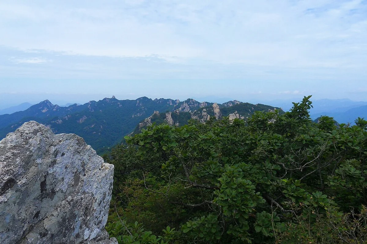
On the trail to the summit, the mountain delivers what the temple promises. Munjangdae — a granite outcrop at 1,033 meters where King Sejo allegedly sat reading poetry — offers views across a cloud sea on clear mornings. The ridgeline connecting Munjangdae to Cheonhwangbong summit runs through eight named peaks, eight scenic outcrops, and eight natural stone gates. The symmetry is intentional: the mountain's geography was mapped in eights, matching Buddhist numerology.
And on the road to the temple, a 600-year-old pine tree stands with its branches raised. According to legend, it lifted them to let King Sejo's palanquin pass in 1464. He granted the tree a ministerial rank. It is Natural Monument No. 103.
Quick Info
Quick summary for planning your Songnisan hike at a glance.
- Location: Boeun-gun / Goesan-gun, Chungcheongbuk-do / Sangju / Mungyeong, Gyeongsangbuk-do, South Korea
- Highest Peak: Cheonhwangbong, 1,058m
- Park Area: 274.8 km²
- Difficulty: Easy (Sejo Trail) to Moderate–Hard (summit loop)
- Best Time to Visit: October (autumn foliage), April–May (spring wildflowers)
- Entrance Fee: Free
- Park Designation: 6th National Park (1970), UNESCO World Heritage (2018)
- Travel Time from Seoul: ~2.5 hours by car or express bus
Trail Overview
| Trail | Distance | Elevation Gain | Time | Difficulty | Best For |
|---|---|---|---|---|---|
| Cheonhwangbong Summit Loop | 16.1km | +1,000m | 7.5–8h | Moderate–Hard | Full summit, Munjangdae, ridge |
| Munjangdae Route (shorter) | 7–9km round trip | +700m | 4–6h | Moderate | Half-day, best views |
| Ridge Traverse | 17.9km | +1,200m cumulative | 4.5h+ (fast pace) | Hard | Multi-peak, experienced hikers |
| Sejo Trail (세조길) | 1–5km segments | minimal | 1–2h | Easy | Culture, families, forest |
Why Songnisan Is Worth the Trip
Songnisan is not the tallest mountain in this guide, and it is not the closest to Seoul. What it is — and no other Korean mountain can claim this — is a UNESCO World Heritage hiking destination. Beopjusa Temple is one of seven mountain monasteries inscribed together in 2018, and the trail from the temple to the summit is effectively a walk through 1,500 years of Korean Buddhist history.
The Palsangjeon — the Hall of Eight Aspects — is the only surviving wooden five-story pagoda built before the modern era in Korea. National Treasure No. 55. The gilt-bronze Maitreya Buddha beside it stands 33 meters tall, originally created by Jinpyo in 776 CE, confiscated by the regent Heungseon Daewongun in the 19th century to fund palace construction, and restored in the 1990s with gold-coating completed in 2002.
Above the temple, the geology takes over. Songnisan's structure is a composite of granite peaks and metamorphic valleys — the granite resists erosion and forms the sharp summits, while the softer metamorphic rock erodes into the deep valleys between them. The contrast produces the dramatic terrain that makes the ridge walk between Munjangdae and Cheonhwangbong one of the most visually varied in central Korea.
For comparison, Gyeryongsan offers a similar temple-traverse structure but at lower elevation and without the UNESCO designation. Odaesan has comparable Buddhist heritage depth but gentler terrain. For a more accessible temple-and-hiking combination, see the Palgongsan guide. Songnisan combines the cultural weight of all three with granite ridge hiking that demands more sustained effort. It's one of the few hikes in Korea where a UNESCO World Heritage site is not just nearby — it's the starting point.

Difficulty and Time Required
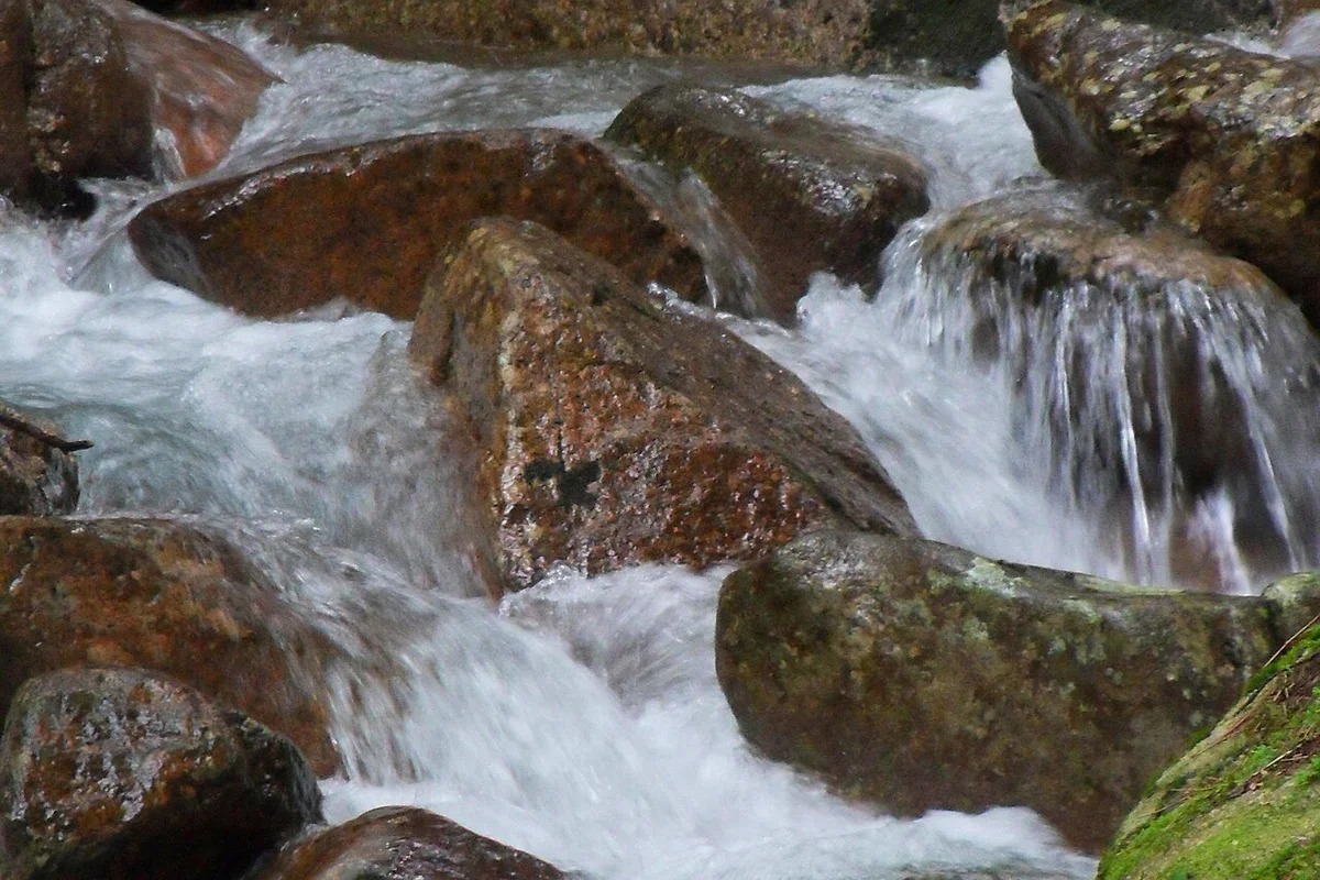
Songnisan is harder than its 1,058-meter elevation suggests. The summit loop from Beopjusa covers 16.1 kilometers with roughly 1,000 meters of cumulative elevation gain — a full 7.5 to 8 hour day. The first 4 kilometers climb gradually through forest, but from Seshimjeong onward, the terrain shifts to stone stairs with irregular step heights and exposed rock faces. There are very few flat sections once you pass Seshimjeong. The ridge between Munjangdae and Cheonhwangbong involves boulder scrambling with sections where hand-climbing is required.
The Munjangdae route is the realistic half-day option — 7 to 9 kilometers round trip, 4 to 6 hours, reaching the best viewpoint without the full summit commitment. The Sejo Trail is flat, accessible, and requires no hiking fitness.
Entry times are restricted by season: 4am to 2pm in summer, 5am to 1pm in winter. Plan accordingly — if you start late, you will be turned back.
Trail Options
Cheonhwangbong Summit Loop — Full Experience
The signature Songnisan route. From the Beopjusa Visitor Center, the trail passes through the temple complex, climbs to Seshimjeong pavilion, continues to Munjangdae, crosses the ridge to Cheonhwangbong summit, and returns.
Stage 1 — Beopjusa to Seshimjeong (3.5km, 1.5h)
The trail begins at the visitor center and passes through Beopjusa Temple — allow time for the temple complex itself. The 33-meter Maitreya Buddha, the wooden Palsangjeon pagoda, and the surrounding halls are worth at least 30 minutes before the trail begins.
The path follows a forest route with wooden decking, stream crossings, and gradually increasing stone steps. Seshimjeong pavilion sits at the convergence of multiple valleys — a natural rest point before the terrain changes.
On the road to the temple, the Jeongipumsong pine stands beside the path — 14.5 meters tall, 600 years old, with branches raised in a permanent gesture. Natural Monument No. 103.
Stage 2 — Seshimjeong to Munjangdae (3.3km, 2h)
The character of the trail changes here. Stone stairs with inconsistent step heights — 30 to 60 centimeters each — replace the forest path. You can't keep a steady pace here — every step is slightly different. The gradient steepens. Exposed rock faces appear. Narrow passages between boulders require careful navigation.
Munjangdae at 1,033 meters is a granite outcrop with open views in every direction. This is the most photographed viewpoint in Songnisan. On clear mornings, cloud seas fill the valleys below. The name means "Literature Pavilion" — King Sejo supposedly read poetry here during his 1464 visit.
Stage 3 — Munjangdae to Cheonhwangbong (3.4km, 2h)
The ridge walk between the two peaks is exposed and demands attention. Boulder scrambling with short hand-climbing sections. In some sections, you'll need to use your hands for balance. The ridge narrows in places with drops on both sides. Wind can be fierce at this elevation regardless of season. The summit itself is a rocky plateau with a stone cairn and 360-degree views when clear.
Stage 4+5 — Return to Beopjusa (7km, 2.5–3h)
The descent reverses the route. Downhill footing on irregular stone stairs is harder on the joints than the ascent — take it slowly.
Round trip: 7.5 to 8 hours. Requires hiking boots, fitness for sustained climbing, and comfort with exposed rock.
Best for: Experienced hikers wanting the full Songnisan experience, anyone combining summit and UNESCO temple visit.
Munjangdae Route — Best Views, Shorter Day
The practical half-day option. An alternate trailhead approach reaches Munjangdae without continuing to Cheonhwangbong, covering 7 to 9 kilometers round trip in 4 to 6 hours. The viewpoint at Munjangdae is arguably better than the summit — the cloud sea phenomenon, when it occurs, is best observed from this elevation.
Best for: Half-day hikers, photographers, those wanting the best scenic payoff for moderate effort.
Sejo Trail — Cultural Walk
A purpose-built trail commemorating King Sejo's 1464 visit. Forest paths and wooden deck sections trace the royal route to Beopjusa. Variable segments of 1 to 5 kilometers, all easy gradient, with interpretive signage throughout.
Best for: Families, cultural interest, those visiting the temple without summit hiking, forest bathing.
Best for Most Travelers
If you have one full day and strong fitness: Cheonhwangbong summit loop. The 16.1-kilometer route from Beopjusa covers both Munjangdae and the summit in 7.5 to 8 hours. Start early to respect the entry time cutoff.
If you have a half day: Munjangdae route. Seven to nine kilometers round trip, 4 to 6 hours, reaching the best viewpoint on the mountain — the cloud sea phenomenon on clear mornings makes this arguably better than the summit itself.
If you are visiting for the temple and culture only: Sejo Trail and Beopjusa Temple. The UNESCO-inscribed temple complex, the 33-meter Maitreya Buddha, the wooden Palsangjeon pagoda, and the 600-year-old Jeongipumsong pine require no hiking fitness and can fill a half day on their own.
Who Should Do This Hike
Songnisan is for hikers who want a mountain with genuine cultural depth anchored by a UNESCO-inscribed temple. The summit loop is a committed full-day effort — 16 kilometers, 1,000 meters of gain, exposed ridge work — and should not be attempted casually. The Munjangdae route offers the best of the views in a half-day. And the Sejo Trail and Beopjusa Temple complex together make a standalone cultural visit that requires no hiking fitness at all.
The 33-meter golden Maitreya Buddha, the only surviving wooden pagoda, and a 600-year-old pine with a ministerial rank — these are not features shared by any other Korean national park. Whether you summit or not, Beopjusa alone justifies the trip.
Tips Before You Go
- Entry times are restricted. Summer (April–October): 4am to 2pm. Winter (November–March): 5am to 1pm. Late arrivals will be turned back.
- Bring at least 2 liters of water for the Munjangdae route, 3 liters for the full summit loop. No reliable water above Seshimjeong.
- Stone stairs on the upper sections have irregular step heights (30–60cm) and become dangerously slippery when wet. Hiking boots with ankle support are essential.
- The Jeongipumsong pine is beside the road to Beopjusa — don't miss it on the approach.
- In winter, crampons are essential on the ridge sections. Ice forms on the stone stairs from November onward.
- The Palsangjeon (wooden pagoda) and Maitreya Buddha at Beopjusa are best photographed in morning light (9–11am).
- Emergency number: 119.
How to Get There
From Seoul (express bus — recommended): Take an express bus from Dong Seoul Terminal or Seoul Express Bus Terminal to Boeun. Journey time is approximately 2 to 2.5 hours. From Boeun, take a local bus or taxi to the Beopjusa Visitor Center (approximately 20 minutes).
By car: Approximately 160km from Seoul via Jungbu Expressway, roughly 2 to 2.5 hours. Parking is available at the Beopjusa visitor area.
Use Naver Maps for real-time transit directions on the day.
Final Thoughts
Songnisan is the mountain where the trail begins at a UNESCO World Heritage temple and ends on a granite ridge named after a king who read poetry on top of it. Between the two — a 33-meter golden Buddha, a wooden pagoda that has survived since before the modern era, and a 600-year-old pine tree that was promoted to ministerial rank.
The hiking itself is serious. The summit loop demands a full day, real fitness, and comfort on exposed rock. But Songnisan is not a mountain where the summit is the only point. The Munjangdae cloud sea, the Sejo Trail forest walk, and the Beopjusa temple complex each stand on their own. Combined, they produce a day that covers more cultural and natural ground than almost any other single destination in Korean hiking. It's not the easiest mountain to hike, but it's one of the most complete.
For the best hikes reachable directly from Seoul by subway, see the full Seoul hiking guide.
Related Guides
Explore more hiking in Korea:
- Best hikes in Seoul — full overview of Seoul's mountains by subway
- Seoraksan Hiking Guide — Korea's top hiking destination
- Gyeryongsan Hiking Guide — temple traverse near Daejeon
- Palgongsan Hiking Guide — Gatbawi Buddha and summit near Daegu
- Odaesan Hiking Guide — fir forest and temples, Gangwon Province
FAQ
How difficult is the Songnisan summit loop? The 16.1-kilometer loop gains roughly 1,000 meters of elevation with stone stairs, exposed rock faces, and boulder scrambling on the ridge. Allow 7.5 to 8 hours. The Munjangdae route is a shorter alternative at 4 to 6 hours. The Sejo Trail is easy and flat.
How do I get to Songnisan from Seoul? Take an express bus from Dong Seoul Terminal to Boeun (2 to 2.5 hours), then a local bus or taxi to the Beopjusa Visitor Center (20 minutes). By car, the drive is approximately 2 to 2.5 hours via Jungbu Expressway.
What is Beopjusa Temple? Beopjusa is a Buddhist temple founded in 553 CE, inscribed as a UNESCO World Heritage Site in 2018. It holds 3 National Treasures including the Palsangjeon — Korea's only surviving pre-modern wooden five-story pagoda — and a 33-meter gilt-bronze Maitreya Buddha.
Are there entry time restrictions at Songnisan? Yes. Entry is restricted to 4am–2pm in summer (April–October) and 5am–1pm in winter (November–March). Hikers arriving after the cutoff will be turned back by park rangers.
What is the Jeongipumsong pine tree? A 600-year-old pine tree (Natural Monument No. 103) beside the road to Beopjusa. According to legend, it raised its branches to let King Sejo's palanquin pass in 1464, and the king rewarded it with a ministerial rank — the highest honor ever given to a non-human entity in Korean history.
What should I bring for hiking Songnisan? Hiking boots with ankle support for the summit routes. At least 2 liters of water for Munjangdae, 3 liters for the full loop. A wind layer for the exposed ridge. In winter, crampons are essential. The Sejo Trail requires only comfortable walking shoes.
Continue exploring Korea's mountains
More routes, same honest field notes.
Related guides

Same region
ModerateSobaeksan Hiking Guide: Royal Azaleas and Ridges
A practical guide to hiking Sobaeksan National Park — Korea's alpine meadow ridge with Birobong royal azaleas, and flanking UNESCO sites Buseoksa and Sosuseowon.

Same region
ModerateGyeryongsan Hiking Guide: Temple Traverse and Ridge
A practical guide to hiking Gyeryongsan National Park near Daejeon — the Donghaksa-Gapsa temple traverse, Nammae Twin Towers, autumn foliage, and Seoul access.

Similar hike
HardGayasan Hiking Guide: Haeinsa and Tripitaka Koreana
A practical guide to hiking Gayasan National Park — the Haeinsa Temple route to Chilbulbong, the Manmulsang scramble, and UNESCO Tripitaka Koreana woodblocks.