Gyeryongsan Hiking Guide: Temple Traverse and Ridge
A practical guide to hiking Gyeryongsan National Park near Daejeon — the Donghaksa-Gapsa temple traverse, Nammae Twin Towers, autumn foliage, and Seoul access.

Gyeryongsan rises to 845 meters across the boundary of Gongju, Gyeryong City, Nonsan, and Daejeon — roughly 90 minutes from Seoul by KTX. It was Korea's third national park, designated in 1968, and the name means "Rooster Dragon Mountain": the ridgeline connecting Cheonhwangbong, Yeoncheonbong, and Sambulbong is said to resemble a dragon wearing a rooster's crest.
It doesn't have the elevation of Seoraksan. It doesn't have the rock formations of Mudeungsan. What it has is concentration. Three major temples, a ridge traverse, and the Twin Towers — all in a single day. Within 64 square kilometers, Donghaksa (724 CE), Gapsa (~420 CE), and Sinwonsa (651 CE) hold multiple designated Treasures between them. The Donghaksa-Gapsa traverse crosses the main ridge past the Nammae Twin Towers — a pair of Silla-era stone pagodas standing side by side at a ruined temple site — in a single day hike that covers the best of what the mountain offers.
Gyeryongsan is also one of Korea's most spiritually loaded landscapes. The Sindoban valley at its base was identified in Joseon-era prophecy texts as one of the "ten auspicious sites" for surviving national calamity, and by the 1970s it housed 93 new religious sects. The mountain goddess Gyeryong Halmeoni is worshipped in Korean shamanic tradition as the chief deity overseeing all mountain spirits nationwide.
Quick Info
Quick summary for planning your Gyeryongsan hike at a glance.
- Location: Gongju / Gyeryong City / Nonsan / Daejeon, Chungcheongnam-do, South Korea
- Highest Peak: Cheonhwangbong, 845m
- Park Area: 64.71 km²
- Difficulty: Easy (Sutong-gol) to Moderate–Hard (temple traverse)
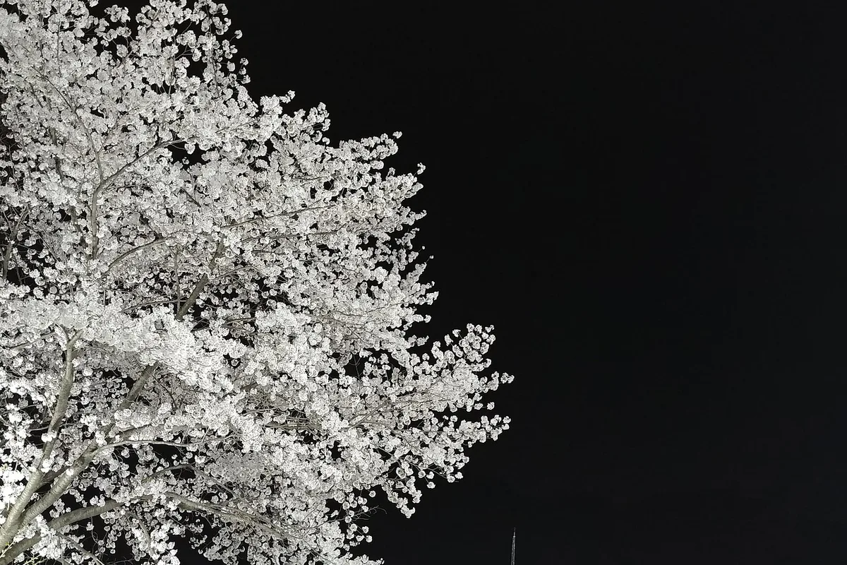
- Best Time to Visit: Late March–April (cherry blossoms), October (autumn foliage at Gapsa)
- Entrance Fee: Free
- Park Designation: 3rd National Park (1968)
- Travel Time from Seoul: ~90 minutes by KTX to Daejeon
Trail Overview
| Trail | Distance | Elevation Gain | Time | Difficulty | Best For |
|---|---|---|---|---|---|
| Donghaksa–Gapsa Traverse | 10+km | +600m | 7–8h | Moderate–Hard | Full ridge, temples, Twin Towers |
| Sinwonsa–Donghaksa Traverse | ~8km | +500m | 6–7h | Moderate–Hard | Quieter, two temples |
| Gapsa Temple Circuit | 5–6km | +400m | 4–5h | Moderate | Autumn foliage, forest |
| Sutong-gol Circular | 5–6km | +300m | 3–4h | Easy–Moderate | Beginners, Daejeon access |
Why Gyeryongsan Is Worth the Trip
Most hikers heading south from Seoul aim for the national parks in Gangwon Province or the southern coast. Gyeryongsan sits in between — accessible from Daejeon in 30 minutes, from Seoul in 90 minutes by KTX — and delivers a temple-to-temple ridge traverse that packs more cultural heritage per kilometer than any other Korean national park hike.
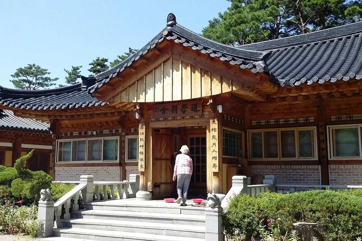
The three main temples represent different eras and traditions. Donghaksa, founded in 724 CE, is Korea's premier bhikkuni (Buddhist nun) training center. Gapsa, dating to roughly 420 CE during the Baekje period, is so famous for its autumn foliage that it has its own nickname — "Chugapsa," meaning "Gapsa in Autumn." Sinwonsa, founded in 651 CE, holds the Jungakdan shrine (Treasure No. 1293), part of the Joseon-era state ritual system that designated Gyeryongsan as the central sacred mountain of the realm.
The Nammae Twin Towers — two stone pagodas at a ruined temple site midway along the ridge — mark the midpoint of the traverse. One seven-story, one five-story, standing side by side. They are designated Treasures No. 1284 and 1285, and the legends attached to them — involving a Silla monk and a pair of siblings — are woven into the trail itself.
For comparison, Palgongsan near Daegu offers similar temple-and-summit character with higher elevation. Odaesan has deeper forest and stronger Buddhist heritage. But neither provides Gyeryongsan's compact traverse structure — three ancient temples, a ridge crossing, and twin pagodas in a single day.
Difficulty and Time Required
Gyeryongsan is moderate by Korean national park standards but should not be underestimated on the traverse routes. The Donghaksa-Gapsa crossing covers over 10 kilometers with 600 meters of cumulative elevation gain, and the Yeoncheonbong-Jayeonseong Ridge section involves steep rock stairs with genuine exposure. The steps are irregular and often high, which breaks your rhythm on the climb — expect 7 to 8 hours for the full traverse.
The Sutong-gol circular on the Daejeon side is the accessible option — 3 to 4 hours, moderate gradient, and a barrier-free 1-kilometer section at the base suitable for visitors with limited mobility.
Granite surfaces become slippery when wet. The north-facing ridge sections ice over in winter. Crampons are essential from December through February.
Trail Options
Donghaksa–Gapsa Traverse — Most Popular
The signature Gyeryongsan hike. From the Donghaksa parking area, the trail climbs through cherry tree groves to the temple, ascends to the main ridge, passes the Nammae Twin Towers, crosses Sambulbong and Gwaneumbong, and descends via the Gapsa valley.
Lower section — Donghaksa Temple (1.5km, 30 min)
The approach passes through a 4.5-kilometer corridor of over 1,000 cherry trees — the site of the annual Gyeryongsan Cherry Blossom Festival in late March to early April. Donghaksa itself is Korea's primary Buddhist nun training center, founded in 724 CE. The temple architecture is traditional and well-maintained, and the setting below the ridge makes a natural starting point.
Mid section — Ridge to Nammae Twin Towers (4km, 2.5h)
The climb starts gently through the temple valley, then steepens sharply before reaching the ridge. The Nammae Twin Towers appear at a cleared site roughly halfway along the traverse — two Silla-era stone pagodas, one seven stories and one five stories, standing at the ruins of Cheongnyangsa Temple. They are Treasures No. 1284 and 1285. The spot offers open views and natural rest space.
Upper section — Sambulbong to Gwaneumbong (3km, 2h)
The ridge walk between the two peaks is the technical heart of the traverse. Sambulbong (775m) and Gwaneumbong (766m) are connected by the Yeoncheonbong-Jayeonseong Ridge — steep granite stairs, exposed rock sections, and sections with drop-offs that require concentration. This is where the route earns its Moderate–Hard rating.
Descent — Gwaneumbong to Gapsa (2km, 1.5h)
The trail drops from the ridge into the Gapsa valley. The descent is steep but the reward is Gapsa Temple — dating to roughly 420 CE, holding a Treasure-designated bronze bell (No. 478), and surrounded by the autumn foliage that gives it the nickname "Chugapsa." In October, the valley floor turns red and orange against the grey granite ridgeline above.
Transport coordination is needed between the Donghaksa and Gapsa parking areas. Taxi or shuttle between the two takes approximately 20 minutes.
Best for: The full Gyeryongsan experience, temple-to-temple pilgrimage, autumn foliage.
Sutong-gol Circular — Best for Beginners
The Daejeon-side approach starts from the Sutong-gol Support Center and loops through Dodeokbong and Geumsubong peaks. At 5 to 6 kilometers and 3 to 4 hours, it is the most accessible option on the mountain. The base includes a barrier-free 1-kilometer trail with guide rails and Braille signage, and the support center offers gear rental — boots, poles, crampons, knee braces, and maps — though availability may vary by season.
Best for: Beginners, families, Daejeon-based visitors, anyone wanting a half-day hike without the traverse commitment.
Sinwonsa–Donghaksa Traverse — Quieter Alternative
The eastern approach from Sinwonsa Temple crosses the ridge via Yeoncheonbong and Gwaneumbong to Donghaksa. At roughly 8 kilometers and 6 to 7 hours, it covers similar terrain to the Donghaksa-Gapsa traverse but with fewer hikers. Sinwonsa holds Treasure No. 1293 — the Jungakdan shrine, a state ritual facility from the Joseon Dynasty.
Best for: Those seeking quieter trails, Buddhist heritage interest, anyone wanting to avoid weekend crowds on the main traverse.
Gapsa Temple Circuit — Best for Autumn
A 5 to 6 kilometer loop from Gapsa Temple through the Orisup ("Eagle Forest") to Sambulbong and back. Allow 4 to 5 hours. The Gapsa valley in October is one of the premier autumn foliage destinations in Chungcheong Province — the combination of ancient temple architecture, stream, and surrounding deciduous forest earns the "Chugapsa" reputation.
Best for: Autumn foliage, moderate half-day hike, Gapsa Temple visit.
Best for Most Travelers
If you have one full day: Donghaksa-Gapsa traverse. The 10-plus kilometer route crosses the main ridge, passes the Nammae Twin Towers, and connects two ancient temples in 7 to 8 hours. Arrange transport between the Donghaksa and Gapsa parking areas in advance.
If you have a half day or want an easier hike: Sutong-gol circular on the Daejeon side. Three to four hours, moderate gradient, barrier-free section at the base, and free gear rental at the support center. This is the most accessible option on the mountain.
If you are visiting for cherry blossoms or autumn foliage: Donghaksa in late March to early April for the 4.5-kilometer blossom corridor, Gapsa in early to mid-October for the foliage that earned it the nickname "Chugapsa."
Who Should Do This Hike
Gyeryongsan suits hikers who want Buddhist cultural heritage integrated into a proper ridge traverse. The Donghaksa-Gapsa route is a full-day commitment — 7 to 8 hours with sustained climbing and exposed ridge sections — appropriate for adults in good fitness with hiking boots and experience on steep terrain. The Sutong-gol circular on the Daejeon side is genuinely accessible, with barrier-free sections and gear rental.
The mountain is compact enough that any of the three major temples can be visited as a standalone cultural trip without hiking — Donghaksa for cherry blossoms in spring, Gapsa for foliage in autumn, Sinwonsa for the Joseon-era shrine year-round.
Tips Before You Go
- Bring at least 2 liters of water. Water is available at the temple areas but nothing reliable on the ridge.
- The Yeoncheonbong-Jayeonseong Ridge section has steep granite stairs with exposure. Hiking boots with ankle support are essential. Do not attempt this section in wet conditions.
- In winter, crampons are mandatory on the north-facing ridge sections. Ice forms consistently from December through February.
- The Donghaksa cherry blossom corridor peaks in late March to early April. The Gapsa autumn foliage peaks in early to mid-October.
- Transport coordination is needed for the Donghaksa-Gapsa traverse — arrange a taxi or check shuttle availability between the two parking areas.
- Gear rental is available at the Sutong-gol Support Center (Daejeon side) — boots, poles, crampons, maps. Availability may vary.
- Emergency number: 119.
How to Get There
From Seoul (KTX — recommended): Take KTX from Seoul Station to Daejeon Station (approximately 50 minutes) or Gongju Station. From Daejeon, take a bus or taxi to the trailhead — Donghaksa is approximately 40 minutes, Sutong-gol approximately 20 minutes.
From Daejeon city center: Bus routes serve all four trailhead areas. The Sutong-gol entrance is the closest to central Daejeon at roughly 20 minutes by bus.
By car: Approximately 160km from Seoul via Gyeongbu Expressway, roughly 2 hours. Parking is available at all major trailheads.
Use Naver Maps for real-time transit directions on the day.
Final Thoughts
Gyeryongsan is the national park where the temples are as important as the trail. The Donghaksa-Gapsa traverse covers three ancient temples, a pair of Silla-era pagodas, and a granite ridgeline in a single day — more cultural density than any other day hike in Korean national park system. The cherry blossoms at Donghaksa in spring and the foliage at Gapsa in autumn give the mountain two distinct peak seasons, and the KTX connection from Seoul makes either a realistic day trip.
As Korea's third national park — designated in 1968, five decades before Palgongsan — Gyeryongsan has the infrastructure maturity and trail maintenance that newer parks are still building. The mountain may not be the highest or the most dramatic, but it may be the most complete single-day hiking experience in central Korea. It's the kind of mountain where you don't just hike — you move between places that have been used for centuries.
For the best hikes reachable directly from Seoul by subway, see the full Seoul hiking guide.
Related Guides
Explore more hiking in Korea:
- Best hikes in Seoul — full overview of Seoul's mountains by subway
- Seoraksan Hiking Guide — Korea's top hiking destination
- Palgongsan Hiking Guide — Gatbawi Buddha and summit near Daegu
- Odaesan Hiking Guide — fir forest and temples, Gangwon Province
FAQ
How difficult is the Gyeryongsan traverse? The Donghaksa-Gapsa traverse is rated Moderate–Hard. The 10-plus kilometer route gains 600 meters of elevation with steep granite stairs and exposed ridge sections on the Yeoncheonbong-Jayeonseong Ridge. Allow 7 to 8 hours. The Sutong-gol circular on the Daejeon side is significantly easier at 3 to 4 hours.
How do I get to Gyeryongsan from Seoul? Take KTX from Seoul Station to Daejeon (approximately 50 minutes). From Daejeon, take a bus or taxi to the trailhead — approximately 20 to 40 minutes depending on the entrance. Total travel time is roughly 90 minutes.
When is the best time to visit Gyeryongsan? Late March to early April for cherry blossoms at Donghaksa (over 1,000 trees across a 4.5-kilometer corridor). Early to mid-October for autumn foliage at Gapsa — nicknamed "Chugapsa" for its renowned fall color.
What are the Nammae Twin Towers? Two Silla-era stone pagodas — one seven stories, one five stories — standing at the ruins of Cheongnyangsa Temple midway along the ridge traverse. They are designated Treasures No. 1284 and 1285 and mark the natural midpoint of the Donghaksa-Gapsa hike.
Is Gyeryongsan suitable for beginners? Yes, on the Sutong-gol circular trail (Daejeon side). This 5 to 6 kilometer route takes 3 to 4 hours with moderate gradient and includes a barrier-free 1-kilometer section. Free gear rental is available at the support center. The traverse routes require more fitness and experience.
What should I bring for hiking Gyeryongsan? Hiking boots with ankle support for the traverse routes. At least 2 liters of water. A wind layer for the exposed ridge. In winter, crampons are mandatory on north-facing sections. For the Sutong-gol trail, any comfortable walking shoes are sufficient.
Continue exploring Korea's mountains
More routes, same honest field notes.
Related guides

Same region
ModerateSobaeksan Hiking Guide: Royal Azaleas and Ridges
A practical guide to hiking Sobaeksan National Park — Korea's alpine meadow ridge with Birobong royal azaleas, and flanking UNESCO sites Buseoksa and Sosuseowon.

Same region
ModerateSongnisan Hiking Guide: Beopjusa and Munjangdae
A practical guide to hiking Songnisan National Park — the Cheonhwangbong summit loop, UNESCO-listed Beopjusa Temple, the 33m Bronze Buddha, and Seoul access.

Similar hike
ExpertBaekdudaegan Hiking Guide: Korea's 701-km Ridge Trail
A practical guide to the Baekdudaegan — Korea's 701-km mountain spine from Jirisan to Hyangnobong, with section-hiking strategy and recommended entry points.