Chiaksan Hiking Guide: Birobong and Guryongsa Trail
A practical guide to hiking Chiaksan National Park near Wonju — the Guryongsa route to Birobong summit at 1,288m, Ladder Ridge scrambling, and Seoul access.

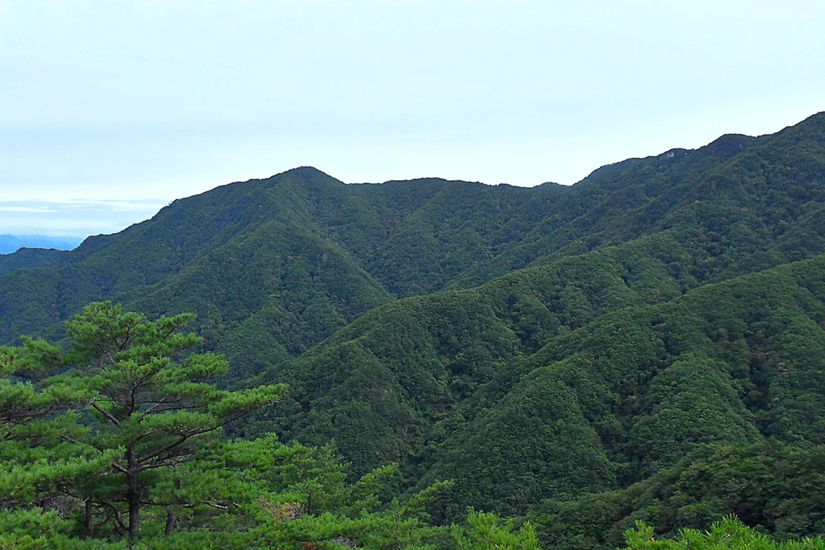
Chiaksan National Park sits in Gangwon Province, straddling the boundary between Wonju and Hoengseong — roughly 90 minutes from Seoul by express bus. Birobong, the park's highest point at 1,288 meters, anchors a north-south ridgeline of six peaks above 1,000 meters: Namdaebong (1,086 meters), Hyangnobong (1,138 meters), Cheonjibong (1,146 meters), Sambong (1,099 meters), and Maehwasan (1,109 meters). The mountain's original name was Jeogaksan — "Red Mountain" — because the autumn foliage turns the entire range crimson from base to summit. It was renamed Chiaksan, meaning "Pheasant Mountain," after a folk legend about a scholar who saved a pheasant from a snake and was repaid with the bird's life.
The geology here is different from Seoul's granite peaks. Chiaksan is built on Precambrian metamorphic rock — primarily biotite gneiss and Geumdae-ri schist, deposited roughly 2,070 to 1,960 million years ago and metamorphosed around 1,860 million years ago. This metamorphic foundation produces thicker soil, denser forest cover, and a wetter, more valley-driven landscape than Seoul's granite mountains. The high infiltration rates of the gneiss bedrock feed the park's stream systems well into autumn, and the weathering patterns create the distinctive boulder fields and talus slopes visible on the upper ridge.
The cultural history runs deep. Guryongsa Temple, founded in 668 CE by the monk Uisang, sits at the base of the main trail — according to legend, on a site where nine dragons once lived. Higher on the mountain, Sangwonsa Temple occupies a site at 1,100 meters elevation on the slopes of Namdaebong, where the pheasant legend that gave the mountain its name is said to have taken place. The park also holds Yeongwonsanseong, a mountain fortress on the western slopes that served as a military defense point for Wonju from the prehistoric period through the Joseon dynasty.
This is not a casual day hike. The Guryongsa route to Birobong includes Ladder Ridge — a steep, exposed rock scramble with over 200 meters of elevation gain in roughly 2 kilometers, with sections that have no fixed ropes. It is the section that separates Chiaksan from the well-maintained staircase trails of Seoul's mountains.
Quick Info
Quick summary for planning your Chiaksan hike at a glance.
- Location: Wonju / Hoengseong, Gangwon Province, South Korea
- Highest Peak: Birobong, 1,288m
- Park Area: 181.6 km²
- Difficulty: Moderate (Bugok) to Hard (Guryongsa via Ladder Ridge)
- Best Time to Visit: October (autumn foliage), April–June (spring)
- Entrance Fee: Free
- Park Hours: Dawn to dusk (seasonal variation)
- Travel Time from Seoul: ~90 minutes by express bus to Wonju
Trail Overview
| Trail | Distance | Elevation Gain | Time | Difficulty | Best For |
|---|---|---|---|---|---|
| Guryongsa Route | 5.7km one-way | +588m | 3.5h up | Moderate–Hard | Valley, waterfall, full summit |
| Bugok Route | 8.5km round trip | +800m | 4–5h | Moderate | Easiest summit approach |
| Hwanggol Route | varies | varies | 4–6h | Moderate–Hard | Solitude, ecology |
| Ridge Traverse | 12–15km | varies | 7–9h | Hard | All peaks, experienced hikers |
Why Chiaksan Is Worth the Trip from Seoul
Chiaksan does not have the name recognition of Seoraksan or the convenience of Bukhansan. What it has is a 1,288-meter summit accessible in a day from Seoul, a valley approach through one of the oldest Buddhist temples in Gangwon Province, and autumn foliage that rivals anything in the country.
The metamorphic rock base produces a fundamentally different hiking experience from Seoul's granite mountains. The trails here run through dense broadleaf forest — Mongolian oak, giant dogwood, and Japanese red pine — with thick understory vegetation and stream crossings throughout. The forest floor is soft, the canopy is dense, and the valleys hold water well into autumn. The contrast with the exposed granite ridges of Bukhansan or Dobongsan is sharp.
Guryongsa Temple, founded in 668 CE by the monk Uisang, sits at the base of the main trail. The emerald-green Guryongso pool near the temple is one of the most distinctive natural features in any Korean national park. Higher up, Seryeom Waterfall marks the transition from valley hiking to serious ridge climbing.
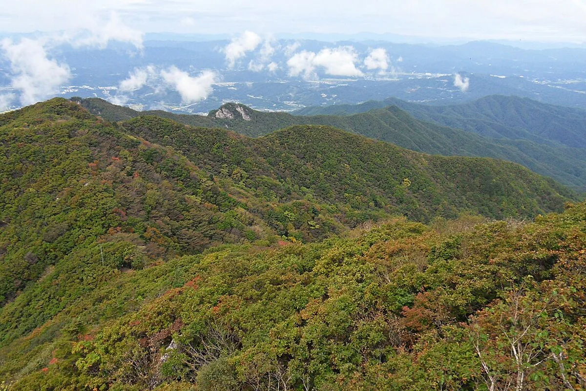
The park supports 3,797 documented animal species, including 13 mammal species, 116 bird species, and over 3,600 invertebrate species. The forest composition is typical of the central Korean temperate zone — dominated by Mongolian oak, giant dogwood, and tulip tree at lower and mid-elevations, transitioning to sparse wind-shaped vegetation on the exposed upper ridge above 1,150 meters.
The park also contains Sunghwangnim Forest — Natural Monument No. 93, designated in 1962 and given additional Special Protection Zone status in 2007 — a grove of ancient trees exceeding 300 years in age, with twice-yearly traditional Sunghwang Festival ceremonies still maintained by local villagers. It was further recognized as a designated Eco-Tourism Area in 2024. It is one of the rare places in Korea where ecological preservation and living cultural practice occupy the same ground.
The name change from Jeogaksan to Chiaksan itself comes from a folk tale rooted at Sangwonsa Temple. According to the legend, a young scholar traveling to the capital examination saved a pheasant from a snake by shooting the snake with an arrow. Later, when the scholar was in mortal danger, three pheasants sacrificed themselves — striking a temple bell with their heads to wake him — repaying his kindness with their lives. The scholar, moved by their sacrifice, abandoned his examination, buried the pheasants, and built a temple on the site. The character for "red" (赤) in the mountain's original name was replaced with the character for "pheasant" (雉).
Difficulty and Time Required
Chiaksan's difficulty depends entirely on which route you choose and how far you go. The Guryongsa approach divides into two distinct halves: the lower valley section from the temple to Seryeom Waterfall is gentle, shaded, and suitable for families. Everything above the waterfall is a different mountain — Ladder Ridge involves sustained, steep rock scrambling on exposed metamorphic rock with sections that have no fixed ropes or handrails.
The Bugok route avoids Ladder Ridge entirely. It starts at a higher elevation (~500 meters) and follows a steadier, less technical path to the summit. The trade-off is less dramatic scenery and limited public bus service — only four departures daily from Wonju.
Birobong summit sits at 1,288 meters. Expect temperatures roughly 8 to 10 degrees cooler than at the trailhead regardless of season, and significantly more wind exposure on the upper ridge.
Trail Options
Guryongsa Route — Best Overall
The Guryongsa approach is the standard Chiaksan experience. From the Guryong Cultural Heritage ticket office, the trail follows the valley through Guryongsa Temple, past Seryeom Waterfall, and up Ladder Ridge to Birobong summit.
Lower section — Ticket office to Guryongsa Temple (1.2km, 45 min)
A gentle forest walk through pine plantations and natural forest. The path is paved and the gradient is mild. Guryongsa Temple — founded in 668 CE — sits in a clearing surrounded by old-growth pine. The Guryongso pool, an emerald-green natural basin near the temple, is worth a stop. According to legend, the temple was built on a site where nine dragons once lived.
Mid section — Temple to Seryeom Waterfall (1.5km, 55 min)
The trail follows the stream through increasingly narrow valley. Rock steps and root-based footing replace the paved path. The Daegok Safety Center at the 2-kilometer mark is the last restroom on the route — note this, because there are no facilities above.
Seryeom Waterfall marks the end of the easy section. The cascade is most impressive after summer rains, when the water volume creates a persistent mist across the trail.
Upper section — Ladder Ridge to Birobong (2.0km, 2h)
This is where Chiaksan earns its reputation. Ladder Ridge is a steep, exposed rock scramble with over 200 meters of elevation gain in roughly 2 kilometers. Many sections have no fixed ropes — you are climbing on raw metamorphic rock with only the friction of your boots and hands for security. The angle is steep enough that a slip on wet rock would have serious consequences.
Multiple false summits test your patience before the final ridge walk to Birobong. The vegetation thins to sparse wind-shaped scrub, and the exposure opens up views in every direction — Wonju to the west, the Taebaek range extending north and south.
This is the section that decides whether you summit or turn back. If Ladder Ridge sounds like too much, the Bugok route gets you to the same peak without it.
Round trip via Guryongsa: approximately 6 to 7 hours. Requires confidence on exposed rock without fixed ropes.
Best for: Experienced hikers, valley and waterfall scenery, the full Chiaksan experience.
Bugok Route — Easiest Summit Approach
The Bugok approach starts at a higher elevation than Guryongsa and follows a steadier gradient to Birobong without the technical difficulty of Ladder Ridge. The 8.5-kilometer round trip takes 4 to 5 hours and is manageable for most adults in reasonable fitness.
The trade-off is access. Public buses from Wonju to the Bugok trailhead run only four times daily — confirm the schedule before planning your hike, or arrange private transportation.
The trail passes through dense temperate forest with multiple water crossings and open meadow sections at higher elevations. The final approach to Birobong is a gentle ridge walk rather than a scramble.
Best for: First-time visitors to Chiaksan who want the summit without technical scrambling, families with older children.
Hwanggol Route — Quieter Alternative
The Hwanggol approach from the north is less traveled and offers the best wildlife observation opportunities in the park. Old-growth forest sections and diverse understory plant communities make this the route for hikers interested in the ecology of the Taebaek range.
Allow 4 to 6 hours depending on summit choice.
Best for: Solitude seekers, ecology interest, repeat visitors.
Ridge Traverse — Full Experience
The full ridge traverse starts from Seongnam-ri near Sunghwangnim Forest and follows the north-south ridgeline over multiple peaks above 1,000 meters to Birobong and descent. The 12 to 15 kilometer route takes 7 to 9 hours and requires navigation skills, scrambling ability, and an early start.
This is Chiaksan for experienced mountain hikers. The traverse crosses both the ancient forest at Sunghwangnim and the exposed alpine ridge at Birobong — two completely different ecosystems in a single day.
Best for: Experienced hikers with a full day, peak-baggers, those wanting the complete Chiaksan traverse.
Best for Most Travelers
If you want the full Chiaksan experience in a single day from Seoul, take the Guryongsa Route but calibrate your turnaround point to your ability. The lower valley section from the ticket office to Seryeom Waterfall — roughly 2.7 kilometers, about 1 hour 45 minutes — is the strongest standalone half-day hike in the park. It passes through Guryongsa Temple (founded 668 CE), the emerald-green Guryongso pool, and the waterfall itself, all on moderate terrain accessible to most fitness levels. This is a complete experience without attempting the summit.
If you want the summit without the technical difficulty of Ladder Ridge, the Bugok Route is the answer. Starting at a higher elevation around 500 meters, it follows a steadier gradient through temperate forest with multiple water crossings and open meadow sections, reaching Birobong via a gentle ridge walk rather than a scramble. The 8.5-kilometer round trip takes 4 to 5 hours. The constraint is access: only four public buses daily from Wonju serve the Bugok trailhead, so confirm the schedule in advance or arrange a taxi.
For experienced hikers comfortable with unroped scrambling on exposed metamorphic rock, the full Guryongsa route through Ladder Ridge to Birobong and back is the definitive Chiaksan day. Budget 6 to 7 hours round trip and do not attempt it after rain.
Who Should Do This Hike
Chiaksan suits hikers looking for a mountain experience beyond what Seoul's peaks offer — higher elevation, denser forest, genuine valley hiking, and a summit that requires real effort to reach. The Guryongsa valley section up to Seryeom Waterfall is accessible to most fitness levels and works as a standalone half-day hike. The full summit via Ladder Ridge is for experienced hikers comfortable with exposure and unroped scrambling.
The Bugok route opens the summit to a wider range of hikers but requires transport planning. Families with children should consider the Guryongsa valley as a destination in itself — the temple, the emerald pool, and the waterfall are worth the trip without attempting the summit.
Chiaksan is not comparable to Seoul's subway-accessible mountains. It requires a 90-minute bus journey, earlier start times, more water, and more preparation. But the scale and character of the hiking here — genuine mountain forest, a 1,288-meter summit, and autumn color that turns the entire range red — justify the extra effort.
Tips Before You Go
- Bring at least 2 liters of water for the Bugok route, 3 liters for Guryongsa to Birobong. The only water source on the Guryongsa trail is at valley level — there is nothing above Daegok Safety Center. In summer, consider carrying 4 liters for the full summit route.
- The Daegok Safety Center is the last restroom on the Guryongsa route. There are no facilities of any kind above this point — plan accordingly.
- Ladder Ridge has sections without fixed ropes. Hiking boots with ankle support are mandatory — trail runners are not sufficient for the upper scrambling. A climbing helmet is advisable for the Ladder Ridge section due to rockfall risk on the steep metamorphic rock.
- Wet rock on Ladder Ridge is genuinely dangerous. Do not attempt the upper Guryongsa route after rain. The gneiss and schist surfaces become extremely slippery when wet, and a fall on the exposed sections would have serious consequences.
- Summit temperatures are roughly 8 to 10 degrees cooler than at the trailhead regardless of season, with significantly more wind exposure on the upper ridge. Layer for temperature swings and carry a windproof shell even on clear days.
- In winter, crampons and insulated layers are essential. Summit temperatures drop to -15 degrees Celsius, and ice forms on the exposed ridge sections. Frozen waterfalls on the Seryeom cascade create dramatic scenery but also hazardous ice around the trail.
- The Bugok trailhead has limited public bus service — only 4 departures daily from Wonju. Verify the current schedule before planning your hike, and confirm return bus times. Taxi from Wonju is approximately 20 to 30 minutes.
- Guryongsa Temple is an active Buddhist site. Remove shoes when entering temple buildings and keep voices low. The Guryongso pool near the temple is a protected natural feature — do not swim or wade in it.
- Sunghwangnim Forest (Natural Monument No. 93), located near Seongnam-ri on the eastern approach, contains ancient trees exceeding 300 years in age. Local villagers maintain twice-yearly traditional Sunghwang Festival ceremonies here. Visitors should stay on designated paths and not disturb the grove.
- Flash flood risk exists in the narrow valley sections of the Guryongsa route during heavy summer rainfall. Check weather forecasts and avoid the valley trail during monsoon-season downpours.
- Trail closures may apply during fire prevention periods. Check the Korea National Park Service website before visiting.
- Emergency numbers: 119 (fire/ambulance), Chiaksan National Park office: 033-740-9900. Mobile coverage is spotty in the valleys but generally available on ridgelines.
How to Get There
From Seoul (bus — recommended): Take an express bus from Seoul Dong Seoul Terminal or Wonju Express Bus Terminal. Buses run frequently, journey time approximately 90 minutes. From Wonju Bus Terminal, take a local bus or taxi to the Guryongsa trailhead (approximately 30 minutes).
Bugok trailhead access: Local buses from Wonju to Bugok run only 4 times daily. Verify the schedule before your hike. Taxi from Wonju is approximately 20 to 30 minutes.
By car: Approximately 130km from Seoul via Yeongdong Expressway, roughly 90 minutes in normal traffic. Parking is available at the Guryong visitor area.
Use Naver Maps for real-time transit directions on the day.
Final Thoughts
Chiaksan is the mountain you go to when Seoul's peaks are not enough. The Guryong Valley approach — from the 7th-century temple through the emerald pool to the waterfall and up Ladder Ridge — is one of the best-structured trail sequences in Korea. The difficulty escalates naturally, the scenery shifts from dense forest to exposed alpine ridge, and the summit at 1,288 meters feels genuinely earned.
If you are visiting Korea in October, the autumn foliage at Chiaksan peaks roughly one week after Seoraksan — making a combined trip to both parks one of the strongest hiking itineraries in the country. For the best hikes reachable directly from Seoul by subway, see the full Seoul hiking guide.
Related Guides
Explore more hiking in Korea:
- Best hikes in Seoul — full overview of Seoul's mountains by subway
- Seoraksan Hiking Guide — Korea's top hiking destination, Gangwon Province
- Bukhansan Baegundae Hiking Guide — Seoul's highest summit
FAQ
How difficult is the Chiaksan Guryongsa trail to Birobong? The lower valley section to Seryeom Waterfall is moderate and suitable for most hikers. Above the waterfall, Ladder Ridge involves steep, exposed rock scrambling with sections that have no fixed ropes. The full round trip takes 6 to 7 hours and is rated Moderate–Hard.
How do I get to Chiaksan from Seoul? Take an express bus from Dong Seoul Terminal to Wonju (approximately 90 minutes), then a local bus or taxi to the Guryongsa trailhead (approximately 30 minutes). Total travel time is around 2 hours.
What is the best time to visit Chiaksan? October is peak season for autumn foliage — the mountain's original name means "Red Mountain" for the color of its autumn canopy. Spring (April to June) offers mild temperatures and wildflowers. Avoid the monsoon season in late July and August.
Can I hike Chiaksan as a day trip from Seoul? Yes. With an early start (leaving Seoul by 7am), the Guryongsa route to Birobong is achievable as a day trip. The Bugok route is shorter but requires coordinating limited bus schedules. Allow a full day including transport.
Is the Bugok route easier than Guryongsa? Yes. The Bugok route starts at a higher elevation and avoids Ladder Ridge entirely, following a steadier gradient to the summit. It takes 4 to 5 hours round trip. The main constraint is limited public bus service — only 4 departures daily from Wonju.
What should I bring for hiking Chiaksan? Hiking boots with ankle support are essential for the Guryongsa route. Bring at least 3 liters of water, food, rain protection, and a headlamp. In winter, crampons and insulated layers are required. There are no food or water vendors inside the park above the entrance area.
Continue exploring Korea's mountains
More routes, same honest field notes.
Related guides

Nearby hikes
ModerateOdaesan Hiking Guide: Fir Forest and Birobong
A practical guide to hiking Odaesan National Park in Pyeongchang — the Birobong summit at 1,563m, Woljeongsa fir forest, Sogeumgang Gorge, and Seoul access.

Nearby hikes
HardSeoraksan Hiking Guide: Ulsanbawi and Daecheongbong
A practical guide to hiking Seoraksan National Park — Ulsanbawi, Daecheongbong summit at 1,708m, Dinosaur Ridge, Biryong Waterfall, and bus access from Seoul.

Nearby hikes
ExpertTaebaeksan Hiking Guide: Cheonjedan Altar and Snow
A practical guide to hiking Taebaeksan National Park — Korea's sacred mountain with the Cheonjedan heaven altar, winter snow flowers, and yew grove trails.