Angels Landing Hiking Guide: Permits, Chains, and How to Climb from Las Vegas
Climb Angels Landing in Zion — the sandstone spine, the chain section, Recreation.gov lottery, and how to plan a half-day hike from Las Vegas.

Angels Landing (5,790 ft / 1,765 m) is a sandstone fin rising 1,500 feet above Zion Canyon and one of the most exposed short hikes in the United States. The 5.4-mile round trip gains 1,500 feet of elevation, and the final half-mile follows a narrow ridge — in places less than five feet wide — with 1,500-foot drops on both sides and fixed steel chains as the only security. Since 2022, all hikers entering the chain section require a permit issued through a Recreation.gov lottery. At least 19 people have died on this trail, most of those deaths since 2000. Most victims were healthy, prepared adults.
Most hikers who turn back on Angels Landing do not turn back at the chains. They turn back at Scout Lookout — the flat platform where the ridge begins and the exposure becomes real. The chains are the famous part. Scout Lookout is where the decision is made.
The trail sits in Zion National Park, roughly 160 miles northeast of Las Vegas. From the Strip, the standard approach is a 2.5-hour drive to the gateway town of Springdale, a free park shuttle to The Grotto trailhead, and a pre-dawn start to clear the chains before midday heat. The full climb takes 4–6 hours for most hikers. Zion was designated the 19th US National Park in 1919, and Angels Landing has been its signature trail since the route was carved into the rock in 1926 by Walter Ruesch, the park's first superintendent.
The name comes from a Methodist minister. In April 1916, Frederick Vining Fisher was exploring the canyon when he looked up at the narrow summit and reportedly said that only an angel could land on it. Fisher went on to name the Great White Throne and the Three Patriarchs — Abraham, Isaac, and Jacob — all evoking the heavenly imagery that matches the park's biblical name. The Southern Paiute people, whose traditional territory includes Zion Canyon, held the area as a place of spiritual significance long before Fisher's visit.
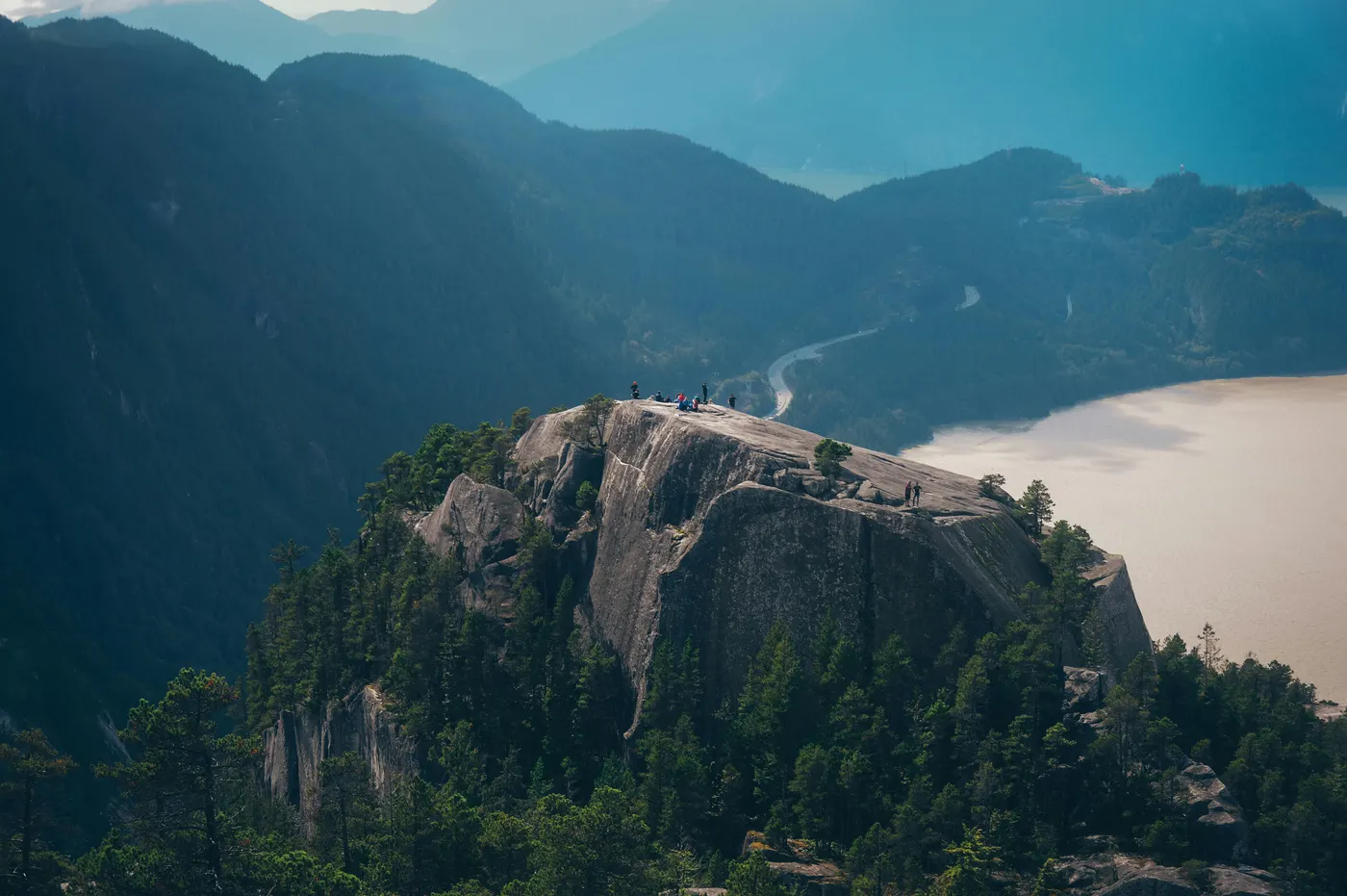
For Korean hikers, the closest comparable experience is Dobongsan's Jaunbong — both end with an exposed rock ridge, fixed chains, and drops on both sides. The difference is scale: Jaunbong's exposed section runs roughly 50–100 meters with drops of 50–150 meters; Angels Landing's chain section runs 800 meters with drops of 460 meters on each side. The time commitment is similar — both are half-day hikes. The exposure intensity is not. For a cable-section comparison closer in form to Half Dome, Bukhansan's Baegundae is the better analog. Angels Landing is the next step beyond both: shorter than Half Dome, more exposed than Baegundae, and harder to get permission for than either.
⚠️ 2026 Permit System (Read First)
You cannot hike past Scout Lookout to the Angels Landing summit without a permit. This applies year-round — there is no off-season workaround. The Recreation.gov lottery is the only path.
What you need to do before climbing:
- Apply through Recreation.gov at recreation.gov/permits/4675310
- Pay the $6 application fee (non-refundable, charged regardless of outcome)
- Pay an additional $3 per person if your application is selected
- Bring photo ID matching the permit holder name — checked by rangers near Scout Lookout below the chain section
Two ways to enter:
| Lottery | When to Apply | Result | Notes |
|---|---|---|---|
| Seasonal (recommended) | ~3 months before hike season, 20-day window | ~1 week after close | Up to 7 preferred dates, 6 people per application |
| Day-Before | Day before climb, 12:01 AM – 3:00 PM MT | Same evening | Best odds on weekdays and shoulder seasons |
2026 Seasonal Lottery Calendar:
| Hike Period | Application Window |
|---|---|
| Spring (Mar 1 – May 31) | January 1–20 |
| Summer (Jun 1 – Aug 31) | April 1–20 |
| Fall (Sep 1 – Nov 30) | July 1–20 |
| Winter (Dec 1 – Feb 28) | October 1–20 |
The permit system was introduced on April 1, 2022, after peak summer days saw over 1,000 hikers on the chain section — creating dangerous bottlenecks on a ridge five feet wide with no room to pass safely. The lottery reduced crowding significantly, though fatal accidents have still occurred after the permit system was introduced — crowd control does not eliminate the exposure risk.
⚠️ Foreign visitor entry fees (2026): Zion is one of 11 US national parks where non-US residents aged 16 and older now pay a $100 per person surcharge on top of the standard $35 vehicle fee, effective January 1, 2026. A group of four foreign hikers will pay $400 in per-person surcharges plus the $35 vehicle fee before any permit costs.
For groups visiting multiple parks, the America the Beautiful Non-Resident Annual Pass ($250) covers the surcharge for the pass holder plus all passengers in a private vehicle, and is valid at all 11 surcharge parks for 12 months. For a Southwest road trip hitting Zion, Bryce Canyon, and Grand Canyon, the pass pays for itself on the second park.
Quick Info
Quick summary for planning your Angels Landing climb at a glance.
- Location: Zion National Park, Washington County, Utah, USA
- Summit: 5,790 ft (1,765 m)
- Round Trip: 5.4 mi (8.7 km)
- Elevation Gain: 1,500 ft (460 m)
- Difficulty: Hard (exposure, not distance)
- Chain Section: 0.5 mi (0.8 km), year-round
- Permit: Required year-round via Recreation.gov lottery
- Cost: $6 application + $3/person permit + $35/vehicle entry + $100/person foreign surcharge (or $250 Non-Resident Annual Pass)
- Travel Time from Las Vegas: ~2.5 hours by car
- Best Season: Spring (March–May) and Fall (September–November)
Trail Overview
| Trail | Distance (round trip) | Elevation Gain | Time | Difficulty | Best For |
|---|---|---|---|---|---|
| Angels Landing (full) | 5.4 mi (8.7 km) | 1,500 ft (460 m) | 4–6h | Hard, very exposed | Permit holders seeking the full ridge experience |
| Scout Lookout only | 3.6 mi (5.8 km) | 1,066 ft (325 m) | 2–3h | Moderate–Hard, no exposure | No permit required; same canyon views minus the spine |
| West Rim Trail (extended) | 15.5 mi (25 km) | 4,396 ft | 8–10h or overnight | Expert | Backpackers (separate wilderness permit needed) |
Best Trail for Most Hikers
If you have a permit, the full Angels Landing trail is the only route — there are no alternative approaches to the summit. The decision is binary: chain section or turn around at Scout Lookout.
If you do not have a permit, Scout Lookout is not a consolation prize. It is a 3.6-mile hike with 1,066 feet of elevation gain, Walter's Wiggles, Refrigerator Canyon, and panoramic views of Zion Canyon from the platform where the chains begin. Many hikers photograph the chain section from here and walk away satisfied. The views are the same; the exposure is not.
For other priorities:
- Angels Landing (full) — the chain section, the drops, the summit. Permit required.
- Scout Lookout only — same trail minus the final 0.5-mile ridge. No permit needed. Strong recommendation for anyone who found Baegundae's cables unnerving.
- West Rim Trail — a 15.5-mile backpacking extension from Lava Point to The Grotto. Requires a separate wilderness permit.
If you are not sure: hike to Scout Lookout, assess honestly, and proceed only if the exposure feels manageable.
Why Angels Landing Is a Different Kind of Climb
Angels Landing's challenge is not physical endurance. The 5.4-mile round trip with 1,500 feet of elevation gain is moderate by American trail standards — roughly the effort of climbing Gwanaksan from Seoul. The challenge is psychological: a half-mile of continuous exposure on a ridge where both sides drop 460 meters to the canyon floor, with steel chains as the only protection.
This is the fundamental difference from Half Dome. Half Dome is a 14-mile endurance test with a cable section as the finish. Angels Landing is a 5-mile warm-up with a fear test as the finish. Half Dome's cable section runs 400 feet on a single face; Angels Landing's chain section runs 0.5 miles across a narrow spine with drops on both sides for the entire distance. On Half Dome, the exposure is in front of you. On Angels Landing, the exposure is on your left and your right, simultaneously, for 30–60 minutes.
The geological framing explains the shape. Angels Landing is a sandstone fin — a narrow remnant of Navajo Sandstone left standing after the Virgin River carved away the rock on both sides over millions of years. The Navajo Sandstone itself is ancient: roughly 180 million years old, deposited as windblown sand dunes in a Sahara-scale desert. In the cliff faces, the cross-bedding patterns from those ancient dunes are still visible. The result is not a peak that rises to a point but a blade of rock that drops away on both sides — the geological opposite of a dome summit like Half Dome's 13-acre plateau.
The cultural framing comes from two directions. The Southern Paiute people — the original inhabitants of this canyon — held the area as spiritually significant. In 1858, a Southern Paiute guide led Mormon missionary Nephi Johnson into the upper Virgin River canyon; Johnson founded the town of Virgin the same year. Mormon settler Isaac Behunin named the canyon "Zion" — the biblical refuge. When Frederick Vining Fisher arrived in 1916 and declared that only an angel could land on the narrow summit, the name joined a landscape already steeped in sacred language. The trail itself was carved into the rock in 1926 under Walter Ruesch's supervision, and the chains were added in the years that followed. The half-mile spine section was listed on the National Register of Historic Places in 1987.
What separates Angels Landing most clearly from Korean mountains is the timed permit model. Korean national parks operate on near-open access — no booking, no fee, no advance planning for most trails. Angels Landing operates on a quarterly lottery with fixed application windows, daily quotas, and time-slot assignments. This is structurally different from both Mount Fuji's reservation system (first-come, first-served slots) and Half Dome's annual + daily lottery (two draws per year). Three mountains, three permit models — and the planning starts months before you reach any trailhead.
Difficulty and Time Required
Angels Landing is harder than the distance suggests. The challenge is exposure and heat — not altitude or distance.
Distance and elevation gain. The full trail covers 5.4 miles round trip with 1,500 feet of elevation gain. Most hikers take 4–6 hours from trailhead back to trailhead, including time on the chains. By comparison, Half Dome is a 14.2-mile endurance test with 4,800 feet of gain over 10–14 hours. Angels Landing is a third of the distance, a third of the elevation, and twice the exposure per foot.
Walter's Wiggles. The 21 tight switchbacks below Scout Lookout gain roughly 250 feet in a narrow strip of cliff face. This is where most physical fatigue hits — not the chains. Built in 1926 by Walter Ruesch, Zion's first superintendent, the Wiggles are an engineering marvel compressed into a punishing quarter-mile.
Chain section. The final 0.5 miles from Scout Lookout to the summit follow a bare sandstone spine with fixed steel chains anchored into drilled holes every 10–25 feet. The ridge width varies from roughly five feet at the wider points to less than three feet at the saddles. Five distinct high points and saddles must be crossed, each requiring both hands on the chains. The chains take 30–60 minutes to ascend depending on traffic, with two-way congestion at the saddles adding delay even under the permit system.
Heat. Zion Canyon hits 100°F (38°C) or higher in July and August, and the sandstone radiates heat — the surface temperature can run 5–10°F above the air. Most of the trail is fully exposed with no shade except Refrigerator Canyon. Summer hikers who start after 8 AM risk heat exhaustion on the return. The standard guidance is unambiguous: start before 6 AM in summer.
Wet sandstone rule. Navajo Sandstone has excellent traction when dry — coarse-grained, gritty, almost grippy. When wet, friction drops catastrophically. The trail becomes unmanageable in rain. Summer monsoon storms (July–September) bring sudden afternoon rain, and the steel chains become lightning conductors. If rain begins, descend immediately. This is not a judgment call.
Standard schedule (half-day climb, pre-dawn walk-in):
- 4:30 AM — leave Springdale lodging on foot, headlamp on
- 4:45 AM — pass Zion Visitor Center, continue along the canyon road
- 6:00 AM — arrive The Grotto (Stop #6), begin hike
- 7:00 AM — Refrigerator Canyon
- 7:30 AM — Walter's Wiggles
- 7:45 AM — Scout Lookout (permit check, decision point)
- 8:15–9:00 AM — chain section ascent
- 9:00–9:30 AM — summit, rest
- 10:00 AM — begin descent
- 12:00 PM — back at trailhead
The first Zion Canyon shuttle departs at 7:00 AM — too late to clear the chains before midday heat in summer. The 3.7-mile canyon road from the Visitor Center to The Grotto is closed to private vehicles but open to pedestrians year-round, so most early-start hikers walk in pre-dawn. This schedule clears the chains before the heat peaks and before afternoon thunderstorms in monsoon season. The descent through Walter's Wiggles is where most twisted ankles occur — take it slowly.
Trail Options
Angels Landing — The Full Route
The only route to the summit, used by every permit holder.
The trail starts at The Grotto (Zion Canyon shuttle Stop #6, elevation ~4,300 ft) and immediately crosses the Virgin River on a footbridge. The first 1.5 miles climb through open switchbacks on the canyon wall with almost no shade — this section is punishing in summer heat. The trail enters Refrigerator Canyon, a brief, cool, shaded gorge between two cliff faces that provides the only natural relief on the entire route.
From Refrigerator Canyon, the trail climbs Walter's Wiggles — 21 steep switchbacks gaining roughly 250 feet in a quarter-mile, carved directly into the cliff in 1926. At the top of the Wiggles sits Scout Lookout: a flat sandstone platform with restrooms, canyon views, and the ranger station that checks permits and IDs.
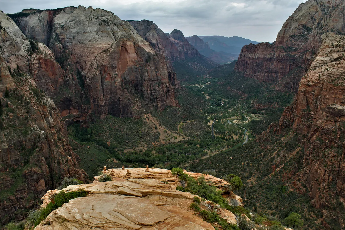
From Scout Lookout, the trail changes character entirely. The final 0.5 miles follow the exposed sandstone spine to the summit. Chains are anchored intermittently along the route — not continuously. Some sections have chains on both sides; others have chains on one side only; a few short stretches have no chains at all. The ridge crosses five distinct high points and saddles, each requiring careful footing and both hands. The summit itself is a small sandstone platform — nothing like Half Dome's 13-acre plateau — with views in every direction: Zion Canyon below, the Virgin River catching light, and the red-and-white cliff walls of Navajo Sandstone on all sides.
Scout Lookout — No Permit Required
If the lottery does not go your way, Scout Lookout is the destination.
The hike to Scout Lookout covers 3.6 miles round trip with 1,066 feet of elevation gain and takes 2–3 hours. You get the full Zion Canyon experience — the river crossing, Refrigerator Canyon, Walter's Wiggles, and panoramic views from the platform — without the chain section. From Scout Lookout, you can see the chain ridge stretching out ahead and watch hikers on the spine. Most first-time Zion visitors who hike to Scout Lookout walk away calling it the best hike they have done.
This is also the honest recommendation for anyone who found Baegundae's short cable section unnerving, or who has strong reactions to height exposure. Scout Lookout is not failure. It is the same trail, the same views, without the risk.
West Rim Trail — Backpacking Extension
For ambitious backpackers, Angels Landing connects to the longer West Rim Trail — 15.5 miles total, 4,396 feet of elevation gain, typically hiked over two days as a point-to-point from Lava Point to The Grotto. This requires a separate wilderness permit from the Zion Visitor Center. The West Rim Trail is a different category of hike entirely — overnight, backcountry, and unrelated to the chain section.
The Chain Section — The Critical Half-Mile
After Scout Lookout, all hikers converge onto the sandstone spine. From this point, exposure is continuous.
Chain section structure (0.5 mi, +434 ft). Heavy-gauge steel chains are anchored into drilled holes in the Navajo Sandstone, supported by steel posts spaced every 10–25 feet depending on the terrain. The chains function as handrails, not harnesses — they prevent drift but will not catch a fall. The spine width at the saddles drops below three feet. Both sides fall away 1,500 feet to the canyon floor.
Going up: Keep one hand on the chain at all times, two hands at the saddles. Pass slower groups only at wider sections — never mid-span. Rest at the wider rock ledges, not on the spine itself. Time to summit from Scout Lookout: 30–60 minutes.
Going down: Most hikers face forward descending — riskier than backward but psychologically easier. Yield to ascending hikers — they have momentum. The descent is where most fatigue-related accidents occur. Time back to Scout Lookout: 30–45 minutes.
Footwear matters here. Navajo Sandstone is gritty when dry and glass-slick when wet. Sticky-rubber approach shoes or trail runners outperform stiff hiking boots on this surface. Worn-out soles are genuinely dangerous. No sandals, no flip-flops — people have died wearing them.
Fatality statistics. At least 19 people have died on Angels Landing since the trail's construction — 17 from falls, 2 from medical events. Most of those deaths have occurred since 2000. Most victims were healthy adults. The common pattern: rushing, distraction during photos, wet rock, or strong wind. The 2022 permit system reduced crowding but did not change the trail's geometry. The chains are maintained regularly; the risk is the exposed rock between them.
Recommended Plan (Half-Day Climb)
The standard approach for most Angels Landing permit holders:
Day Before
- Arrive Springdale by mid-afternoon (2.5 hours from Las Vegas)
- Check in at lodging in Springdale (Cable Mountain Lodge, Cliffrose, or Desert Pearl — all walkable to park entrance)
- Verify Angels Landing permit and photo ID
- Pre-pack daypack: 3–4L water, energy bars, electrolytes, sun hat, sunscreen, headlamp, rain shell
Climb Day
- 4:30 AM — leave Springdale lodging on foot, headlamp on
- 4:45 AM — pass Zion Visitor Center, continue along the canyon road
- 6:00 AM — arrive The Grotto (Stop #6), begin hike
- 7:30 AM — Walter's Wiggles
- 7:45 AM — Scout Lookout (permit + ID check)
- 8:30 AM — summit
- 9:00 AM — begin descent
- 11:00 AM — back at trailhead
- 11:30 AM — shuttle back to Springdale for lunch
This schedule uses the pre-dawn walk-in along the closed canyon road (open to pedestrians) since the first shuttle at 7:00 AM is too late to clear the chains before heat. The schedule clears the chains well before afternoon heat peaks and avoids monsoon-season thunderstorms that typically arrive after 1 PM. The half-day format leaves the afternoon open for The Narrows, Emerald Pools, or recovery in Springdale.
Who Should Climb Angels Landing
Angels Landing is accessible to fit adults with no technical climbing experience — but only if you can handle sustained exposure to height. The chain section eliminates anyone unprepared for that specific dimension.
Climb Angels Landing if:
- You are comfortable on exposed rock with drops on both sides (not just in front)
- You can complete a 5.4-mile hike with 1,500 feet of elevation gain
- You have functional grip strength for chains across 30–60 minutes
- You have a confirmed lottery permit
- You can start by 6:00 AM and finish by noon
- You have sticky-rubber shoes with intact soles
Skip the chain section if:
- You have a strong fear of heights — Scout Lookout will tell you (this is not a test you want to fail mid-ridge)
- You cannot maintain focus while fatigued (the chain section demands calm concentration)
- Weather forecasts mention afternoon thunderstorms or rain
- You are hiking in winter without micro-spikes (ice on sandstone is worse than wet sandstone)
Honest framing for Korean hikers:
- If you climbed Jaunbong's chain ridge on Dobongsan comfortably — Angels Landing is achievable. The exposure is 8–10 times longer and 3–10 times deeper, but the physical format is the same.
- If you enjoyed Baegundae's cables on Bukhansan — Angels Landing is the next level.
- If Baegundae made you nervous — consider Scout Lookout (no permit needed, same views, no ridge).
Wildlife. Mule deer and rock squirrels are common on the trail; California condors — wingspan roughly 3 meters, the largest bird in North America — are occasionally spotted soaring near the cliffs. Desert bighorn sheep inhabit the canyon. Rattlesnakes are present in summer on warm rocks. Mountain lions are very rare. None of these are significant trail hazards if you maintain awareness.
Tips Before You Go
- Apply early. Seasonal lottery windows are 20 days long, roughly 3 months before each hike period. Include weekday and shoulder-season dates — they have significantly better odds than July weekends.
- Carry 3–4 liters of water. There is no water on the trail above The Grotto. In summer, carry 4–5 liters and add electrolytes — the desert dehydrates faster than altitude.
- Sticky-rubber shoes are non-negotiable. Approach shoes or trail runners with intact Vibram or Stealth soles grip Navajo Sandstone far better than stiff hiking boots. Worn-out soles kill friction.
- Start before 6 AM in summer. The trail is fully exposed. Sandstone radiates heat above air temperature. Hikers who start after 8 AM in July risk heat exhaustion before reaching the chains.
- Headlamp for pre-dawn starts. The shuttle runs from 7 AM, but pre-dawn walkers from Springdale reach The Grotto before the first bus arrives.
- Layer for temperature swings. Pre-dawn at the trailhead may be 10°C; the summit by 9 AM may be 30°C with direct sun. Light, removable layers work best.
- If rain starts, descend immediately. Wet Navajo Sandstone loses friction dramatically. Steel chains conduct lightning. This is not a judgment call — it is park policy.
- Scout Lookout is a legitimate destination. If you do not win the lottery, hike to Scout Lookout anyway. It is the same trail, the same Walter's Wiggles, the same canyon views — without the chain section.
- Cell coverage ends at Scout Lookout. Assume no signal on the chains. Plan accordingly.
- Emergency numbers: 911 (general), Zion Park Emergency (435) 772-3322, Zion Canyon Medical Clinic in Springdale (435) 772-3226.
How to Get There
From Las Vegas (most common): Drive northeast on I-15 for 110 miles, exit at Highway 9 toward Hurricane, continue east through Hurricane and La Verkin to Springdale — Zion's gateway town directly at the park entrance. Total driving time: approximately 2.5 hours, 160 miles. Rental car from LAS (McCarran) is the standard option. For hikers without a car, private shuttle services run Las Vegas–Springdale for roughly $95–190 per seat.
From Salt Lake City: Drive south on I-15 to SR-9, approximately 4.5 hours, 310 miles. Cedar City at the halfway point makes a natural overnight break.
From Los Angeles: Take I-15 north through Las Vegas to SR-9, approximately 6.5 hours, 430 miles. Most travelers split the drive overnight in Las Vegas.
Inside the park: Zion Canyon operates a free shuttle — no ticket, no reservation, no cost beyond your entrance pass. The shuttle runs 9 stops along the canyon road; Angels Landing trailhead at The Grotto is Stop #6. Private vehicles are prohibited on the canyon road during shuttle season (March through November). The 2026 shuttle season begins March 7, with the first bus at 7:00 AM.
Springdale Town Shuttle (also free) connects 9 stops in Springdale to the park's pedestrian entrance. Hotels in Springdale are walkable to the park gate.
Parking: The Visitor Center parking lot is the largest in the park and fills by 8–9 AM in peak season. Springdale has paid parking in three zones ($15–25/day during shuttle season, free after 5 PM). The recommended approach: stay overnight in Springdale, walk to the park entrance, and ride the shuttle. Do not plan to drive to The Grotto — you cannot.
Final Thoughts
Angels Landing rewards nerve more than fitness. The chain section, the narrow spine, the 1,500-foot drops on both sides — all of it adds up to a hike that is harder to face than it is to physically complete. Hikers who cannot handle exposure cannot climb. Hikers who do not win the lottery cannot climb. Hikers who start too late in summer overheat before the chains. The trail is short, but every part of it requires that you have done the right preparation in advance.
The structure of an Angels Landing climb — quarterly lottery, year-round permits, timed slots, mandatory ID checks — places it in the same regulatory category as Half Dome and Mount Fuji, but with a different access rhythm. Half Dome's cables go up seasonally; Fuji's climbing season runs 10 weeks per year. Angels Landing's chains stay up year-round, and the permit requirement never pauses. Three mountains, three permit systems, three different kinds of preparation — and none of them allow walk-up access anymore.
For travelers combining Angels Landing with Korean mountain itineraries, the contrast is sharp. After the lottery system and the $100 foreign surcharge, the open access to Hallasan on Jeju Island or Jirisan on the Korean mainland feels like a release. For climbers approaching Angels Landing as their first major American trail, Dobongsan's Jaunbong is the closest training analog Korean hikers have — a narrow ridge with chains and drops on both sides, similar in form but far smaller in scale, and accessible without permits.
Start early, wear sticky soles, respect the chains, and Angels Landing rewards the composure.
Related Guides
Explore more exposed and permit-based hikes:
- Half Dome Hiking Guide — cables, lottery permits, and the closest comparison to Angels Landing's exposure
- Mount Fuji Hiking Guide — Japan's highest peak, reservation-based access model
- Dobongsan Hiking Guide — closest Korean analog with chain ridge exposure
- Bukhansan Baegundae Hiking Guide — short cable section on granite dome
- Best hikes in Seoul — accessible day hikes with no permits
FAQ
How long does it take to climb Angels Landing? Most hikers take 4–6 hours round trip for the full 5.4-mile trail with 1,500 feet of elevation gain. The standard schedule is a 6:00 AM start with summit arrival around 8:30 AM and return to the trailhead by 11:00 AM. The chain section alone takes 30–60 minutes each way from Scout Lookout. Angels Landing is rated Hard — the difficulty is exposure on the chain section, not distance or altitude.
Do I need a permit to climb Angels Landing? Yes. Since April 2022, all hikers entering the chain section (Scout Lookout to summit) require a permit issued through the Recreation.gov lottery. Seasonal lotteries run four times a year with 20-day application windows roughly 3 months ahead; a day-before lottery covers remaining slots. Permits cost $6 per application plus $3 per person if selected. You can hike to Scout Lookout without a permit — a 3.6-mile, 1,066-foot alternative with the same canyon views. Foreign visitors also pay a $100 per-person park entrance surcharge at Zion starting January 1, 2026 (in addition to the $35 vehicle fee), or can purchase the $250 America the Beautiful Non-Resident Annual Pass for multi-park trips.
When is the best time to climb Angels Landing? Spring (March–May) and fall (September–November) offer the best conditions — mild temperatures, manageable crowds, and reasonable lottery odds. Summer (June–August) brings extreme heat above 100°F and afternoon monsoon thunderstorms. Winter is possible but risky — ice on the sandstone makes the chain section dangerous, and micro-spikes are essential. The chains stay up year-round; the permit is required in all seasons.
Can beginners climb Angels Landing? With proper preparation and honest self-assessment, yes — but Angels Landing demands comfort with extreme exposure more than fitness. The physical effort is moderate (5.4 miles, 1,500 feet of gain). The mental demand is high: a half-mile of continuous exposure with 1,500-foot drops on both sides. If you found Dobongsan's Jaunbong or Bukhansan's Baegundae unnerving, consider stopping at Scout Lookout — it is the same trail without the chain section and requires no permit.
How dangerous is the chain section? At least 19 people have died on Angels Landing since the trail's construction — 17 from falls, 2 from medical events. Most of those deaths have occurred since 2000, including incidents after the 2022 permit system was introduced. Most victims were healthy adults. The chains are maintained regularly; the risks are wet sandstone, wind, fatigue, distraction, and crowding at the saddles. Following park guidance — start early, descend if rain begins, use both hands at saddles — significantly reduces preventable risk.
Is Angels Landing worth climbing? Yes. Angels Landing is one of the most exposed short hikes in the United States — a half-mile of continuous double-sided exposure on a sandstone spine with canyon views in every direction. The chain section delivers an intensity that longer, higher mountains do not match in the same concentrated distance. For hikers who secure a permit and start early, it is a half-day experience in one of America's most dramatic national parks. And if the lottery does not go your way, Scout Lookout alone justifies the trip.
Continue exploring Korea's mountains
More routes, same honest field notes.
Related guides

Nearby hikes
HardHalf Dome Hiking Guide: Cables, Lottery Permits, and How to Climb from San Francisco
A practical guide to climbing Half Dome in Yosemite — Mist Trail, Sub Dome, the cable section, the Recreation.gov lottery, and how to plan from San Francisco.

Same region
HardMount Fuji Hiking Guide: Yoshida Trail, Permits, and How to Get There from Tokyo
A practical guide to climbing Mount Fuji — Japan's highest mountain at 3,776m, including the four official trails, the 2025 reservation system, summit sunrise (Goraiko), and bus access from Tokyo.