Half Dome Hiking Guide: Cables, Lottery Permits, and How to Climb from San Francisco
A practical guide to climbing Half Dome in Yosemite — Mist Trail, Sub Dome, the cable section, the Recreation.gov lottery, and how to plan from San Francisco.
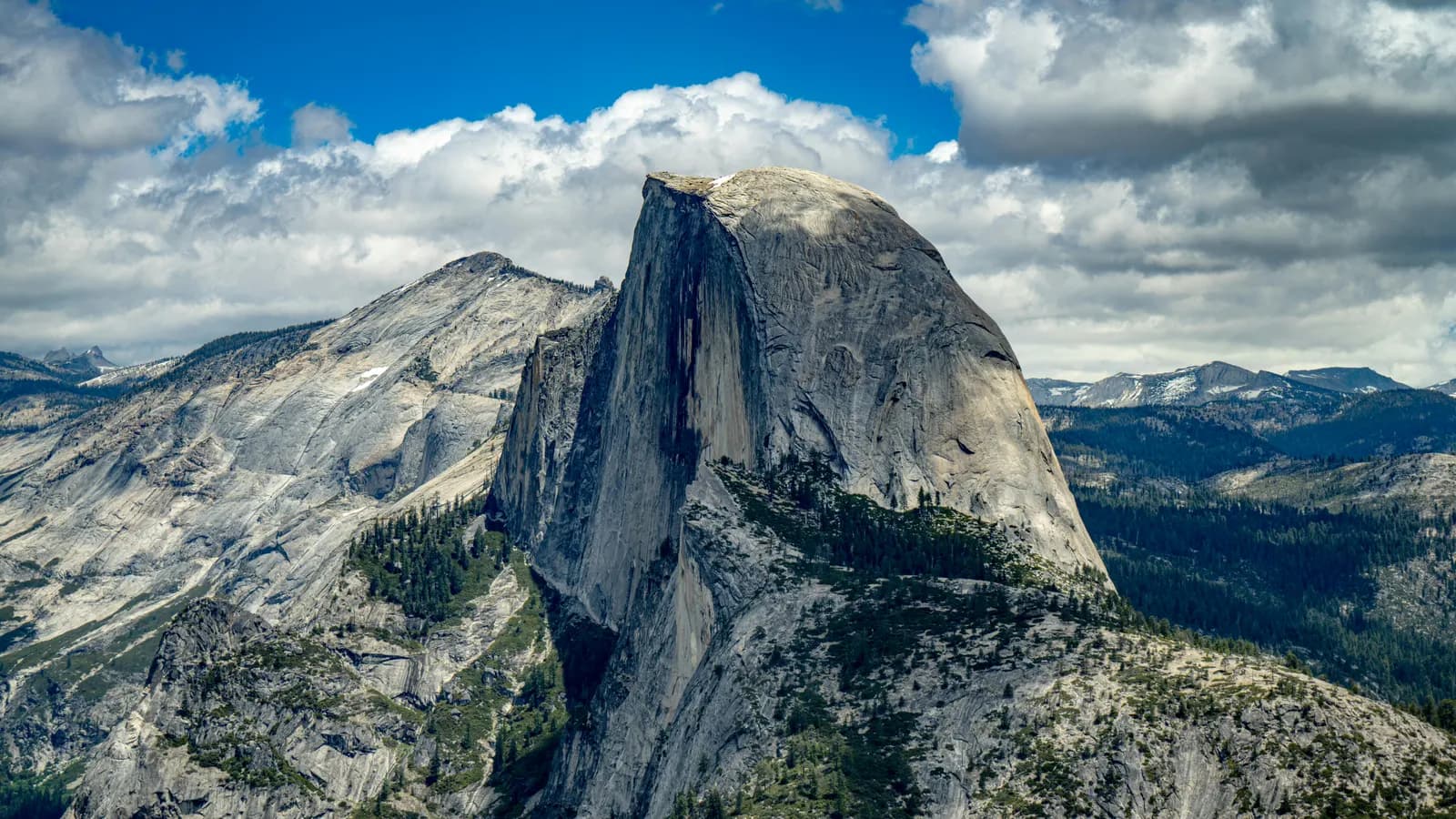
Half Dome (8,839 ft / 2,694 m) is the granite dome that defines Yosemite National Park's skyline and one of the most demanding day hikes in the United States. The 14.2-mile round trip covers 4,800 feet of elevation gain, and the final 400 feet ascend a 45–55 degree granite face using two parallel steel cables installed in 1919. Since 2010, all hikers ascending Half Dome on cable-up days require a permit issued through a Recreation.gov lottery — the system that limits the summit to 300 hikers per day.
Most hikers who fail on Half Dome do not fail at the cables. They fail at Sub Dome — the 600 stone steps directly below the cables that strip away anyone unprepared for steep, exposed granite without rails. The cables are the famous part. Sub Dome is where the climb is decided.
The mountain sits in the Sierra Nevada, roughly 170 miles east of San Francisco. From the Bay Area, the standard approach is a four-hour drive to Yosemite Valley, an early-morning shuttle to Happy Isles trailhead, and a 4–5 AM start on the Mist Trail. The full climb takes 10–14 hours for most hikers and requires headlamps for the descent. Yosemite was inscribed as a UNESCO World Heritage Site in 1984 — listed for its outstanding geological and ecological significance, not for cultural reasons. Half Dome is the most photographed feature of that designation.
What separates Half Dome from most regulated mountains is the access model. Like Mount Fuji in Japan, Half Dome operates on quota and permit. Unlike Fuji, the permits are distributed by lottery — there is no first-come, first-served option, and a successful entry depends on luck as much as planning. The cables run only from late May to mid-October. Outside that window, Half Dome becomes a Class 5 technical climb requiring ropes, harnesses, and helmets — beyond the scope of any standard hike.
For Korean hikers planning a US trip, the closest comparable experience is Bukhansan's Baegundae — both have granite dome summits with fixed steel rails on the final approach. Half Dome's cable section is roughly the same length as Baegundae's, but steeper, longer in total trail distance, and at three times the elevation. For high-altitude experience, Hallasan on Jeju is closer in feel to the full-day Half Dome effort, though without any cable or chain section.
⚠️ 2026 Permit System (Read First)
You cannot climb Half Dome on a cable-up day without a permit. Walk-up access does not exist. The Recreation.gov lottery is the only path.
What you need to do before climbing:
- Apply through Recreation.gov at recreation.gov/permits/234652
- Pay the $10 application fee (non-refundable, charged regardless of outcome)
- Pay an additional $10 per person if your application is selected
- Bring photo ID matching the permit holder name — checked at the Sub Dome ranger station
Two ways to enter:
| Lottery | When to Apply | Result | Success Rate |
|---|---|---|---|
| Preseason | March 1 – March 31, 2026 | Mid-April | ~18–22% (popular summer weekends drop to single-digit odds) |
| Daily | 2 days before climb date | Same day, ~9 PM PT | ~19–30% weekdays, ~18% weekends |
Each application allows up to 6 people per group and up to 7 preferred dates. Late September and October offer noticeably better odds than peak summer.
Cable operation dates (2026):
- Cables up: May 25, 2026 (Friday before Memorial Day)
- Cables down: October 16, 2026 (Tuesday after Columbus Day)
- Approximate window: 145 days
⚠️ Foreign visitor entry fees (2026): The National Park Service introduced a new fee structure on January 1, 2026, applying to 11 of the most-visited US national parks including Yosemite, Yellowstone, Grand Canyon, and Zion. Non-US residents 16 and older now pay $100 per person for entry, in addition to the standard $35 vehicle fee. A group of four foreign hikers will spend $400 in per-person fees alone, plus the $35 vehicle fee, before any Half Dome permit costs.
For groups visiting multiple parks or families of three or more, the America the Beautiful Non-Resident Annual Pass ($250) is usually the better option — it covers the pass holder plus three additional adults in a vehicle, and is valid at all 11 surcharge parks plus hundreds of other federal recreation sites for 12 months. Couples or solo travelers visiting only Yosemite typically pay the $100 per person directly.
Note: The $100 surcharge is currently not collected on YARTS buses (the public transit system from Merced to Yosemite Valley), though this may change. Foreign visitors arriving without a car may avoid the per-person fee for now by using YARTS — verify current policy on Recreation.gov before traveling.
Quick Info
Quick summary for planning your Half Dome climb at a glance.
- Location: Yosemite National Park, California, USA
- Summit: 8,839 ft (2,694 m)
- Round Trip: 14.2 mi (22.9 km) via Mist Trail
- Elevation Gain: 4,800 ft (1,463 m)
- Difficulty: Hard
- Cable Season: May 25 – October 16, 2026
- Permit: Required via Recreation.gov lottery
- Cost: $10 application + $10/person permit + $35/vehicle entry + $100/person foreign surcharge (or $250 Non-Resident Annual Pass)
- UNESCO: Yosemite World Heritage Site (1984, natural)
- Travel Time from San Francisco: ~4 hours by car
Trail Overview
| Trail | Distance (round trip) | Elevation Gain | Time | Difficulty | Best For |
|---|---|---|---|---|---|
| Mist Trail (standard) | 14.2 mi (22.9 km) | 4,800 ft | 10–14h | Hard | Standard route, waterfall close-ups |
| John Muir Trail | 16.5 mi (26.6 km) | 4,800 ft | 12–15h | Hard | Less crowded, gentler grade, knee-friendly descent |
| Glacier Point traverse | ~20 mi (32 km) | 5,800+ ft | 14–16h | Expert | Experienced hikers wanting different views |
| Tenaya Lake (backpacking) | ~23 mi (37 km) | Variable | 16h+ | Expert | Multi-day approach |
Best Trail for Most Hikers
If you have one shot at Half Dome, start on the Mist Trail and descend on the John Muir Trail. This combination is the route most experienced Half Dome hikers recommend, for reasons that become obvious after the climb:
- Mist Trail going up — shorter by 1.5 miles, with Vernal and Nevada Falls passing within feet of the trail. The granite stairs alongside Vernal Fall get soaked by the spray; bring a rain jacket.
- John Muir Trail coming down — longer but with a gentler grade. After 10 hours of climbing, descending steep granite stairs on knees and quads becomes painful. The John Muir descent is genuinely easier on the body.
For other priorities:
- Mist Trail both ways — fastest route, most direct, hardest on knees descending.
- John Muir Trail both ways — longest standard option, less crowded, no waterfall close-ups.
- Glacier Point traverse — for hikers who want to see Half Dome from the iconic photographic angle before climbing it.
If you are not sure: book Mist Trail up, John Muir down.
Why Half Dome Is a Different Kind of Climb
Half Dome's challenge is different from any high-altitude climb in Asia. The summit is not particularly high by world standards — at 2,694 meters, it stands taller than Hallasan by less than 750 meters. The challenge is the combination: 14.2 miles of trail, 4,800 feet of climbing, exposure on Sub Dome, and a 400-foot cable section that demands both arms working continuously.
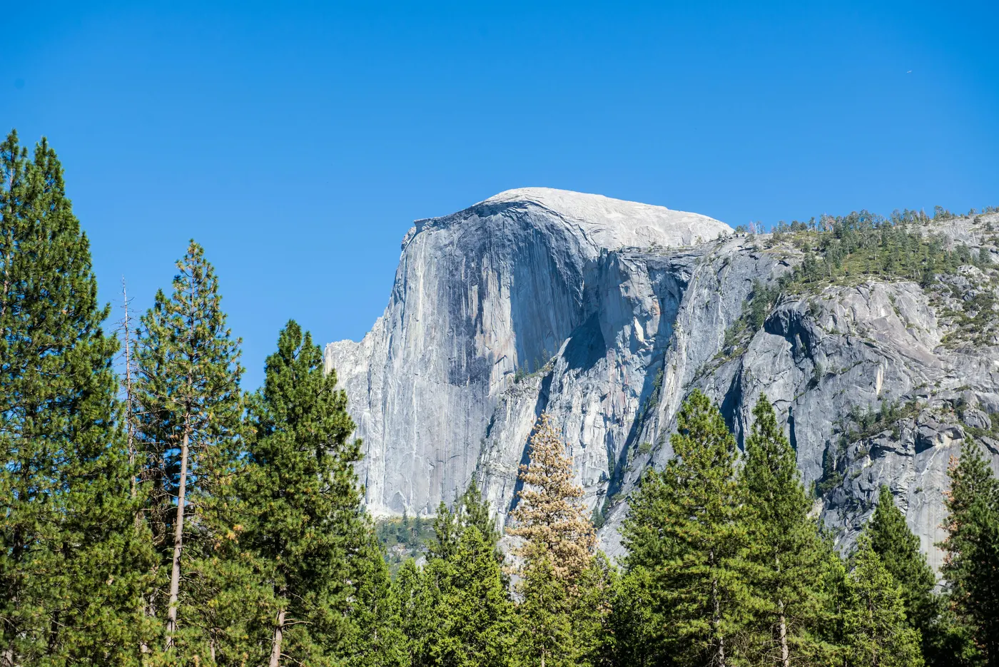
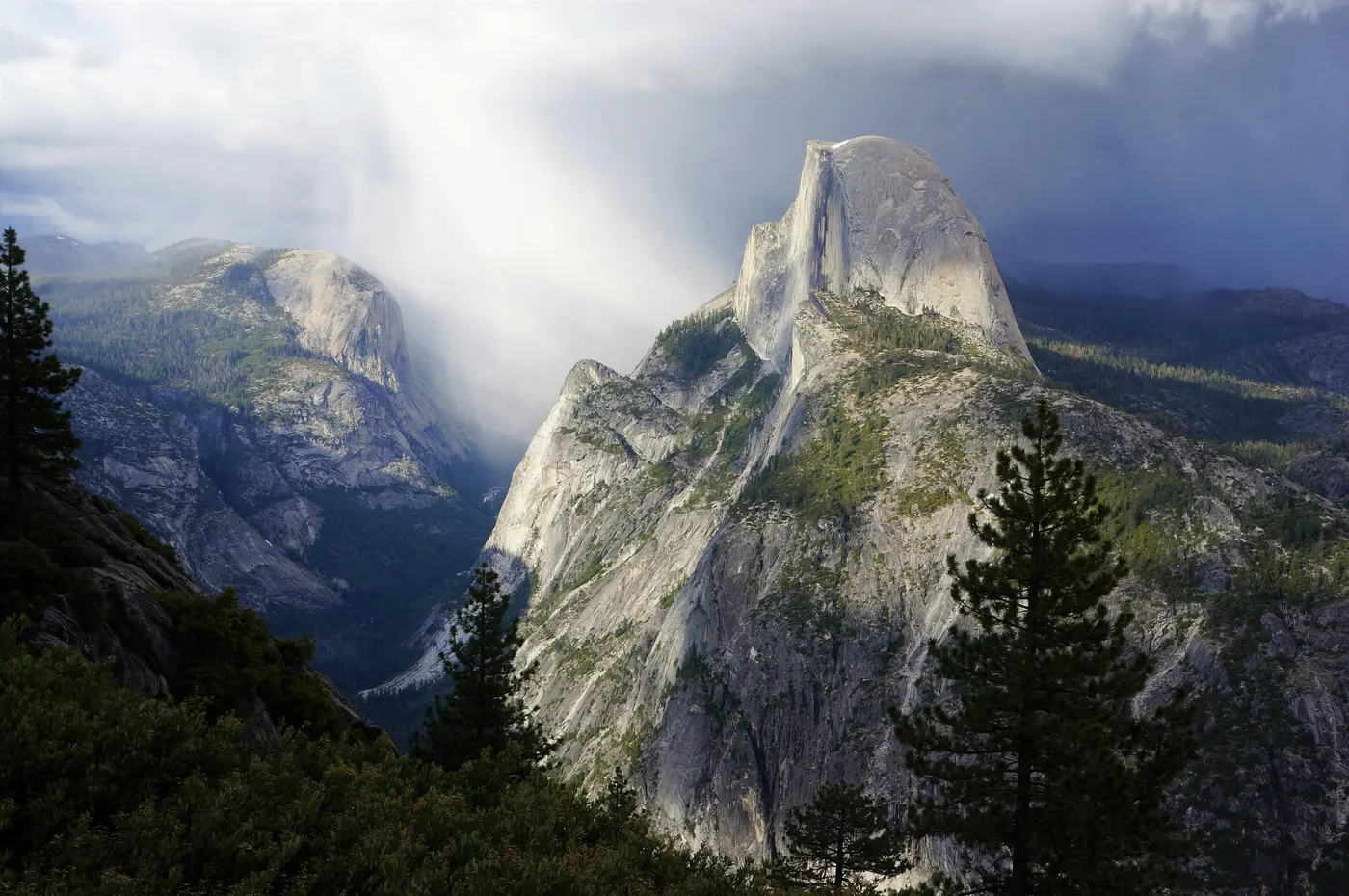
The geological framing is unique. Half Dome is not a peak that rises to a point — it is a granite dome with one side cleaved off, formed not by a single dramatic event but by exfoliation, the slow process by which pressure-released granite peels away in onion-like sheets over millions of years. The face that appears "missing" was never there. The northwest cliff drops roughly 700 meters straight down. The summit itself is a flat 13-acre granite plateau where hikers, having survived the cables, walk casually within feet of the edge.
The cultural framing comes from two sources. The Ahwahneechee — the original Native American inhabitants of Yosemite Valley — knew Half Dome as Tis-sa-ack, named for a young woman in a creation story whose tears, in legend, are the dark vertical streaks visible on the northwest face today. The mountain had a name long before George Anderson, a Scottish-born ship's carpenter, became the first European to summit it on October 12, 1875. Anderson drilled iron eye-bolts into the granite as he climbed, ascending barefoot for additional friction. Some of his original bolts are still embedded in the rock. In 1919, the Sierra Club installed the cable system that hikers use today.
What separates Half Dome most clearly from a Korean mountain climb is the lottery permit model. Korean national parks operate on near-open access — most trails require no booking, no fee, and no advance planning. Half Dome operates on a Recreation.gov lottery where popular summer weekends are heavily oversubscribed, and any single preferred date may take multiple seasons of attempts to win. If you have hiked Bukhansan's Baegundae, the cable section will feel familiar in form — granite dome, fixed steel, both hands required. The differences are scale and access: Baegundae is a 4–5 hour climb you can attempt next weekend; Half Dome is a 14-hour climb you may not get permission to attempt for two summers running.
Difficulty and Time Required
Half Dome is harder than the elevation suggests. The challenges are distance, exposure, and the cable section — not altitude.
Distance and elevation gain. The standard Mist Trail route covers 14.2 miles round trip with 4,800 feet of elevation gain. Most hikers take 10–14 hours from trailhead back to trailhead. The John Muir Trail variation adds 2.3 miles. The total effort is roughly equivalent to climbing four major Korean mountains in a single day, with the added complexity of an exposed cable finish.
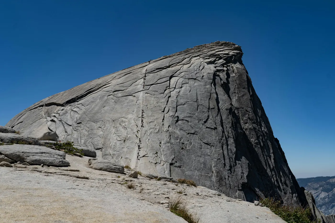
Sub Dome. The 0.3-mile section directly below the cables gains 460 feet across approximately 600 hand-cut granite steps. The exposure is severe — the granite slope drops away on both sides with no rails, no fixed lines, and no margin for hesitation. Hikers prone to vertigo or fear of heights often realize their limits here, before the cables. This is the section where most failed Half Dome attempts end.
Cable Section. The final 400 feet of granite ascends at 45–55 degrees. Two parallel steel cables, supported by metal posts at 10–20 foot intervals with wooden plank footing between them, allow hikers to ascend without technical climbing equipment. The cables take about 30 minutes to ascend in normal conditions, longer when traffic backs up. Gloves are essential — the cables are narrow steel, and friction on bare hands during a long ascent leads to lacerations and grip failure.
Weather windows. Sierra Nevada afternoons in summer produce reliable thunderstorms, particularly in July and August. Wet granite kills the friction the entire cable system depends on. Steel cables become lightning conductors. The official park guidance is unambiguous: if rain begins, descend immediately. Most experienced Half Dome hikers start at 4–5 AM specifically to clear the summit before noon.
Standard schedule (single-day climb):
- 4:00–5:00 AM — depart Happy Isles trailhead with headlamp
- 6:30–7:00 AM — Vernal Fall
- 7:30–8:30 AM — Nevada Fall
- 11:00 AM–12:00 PM — base of Sub Dome
- 12:30–1:30 PM — summit
- 2:00 PM — begin descent
- 6:00–8:00 PM — back at trailhead
Trail Options
Mist Trail — Standard Route
The most direct path to Half Dome and the route used by roughly 90% of permit holders.
The trail starts at Happy Isles (Yosemite Valley shuttle stop #16, elevation ~4,000 ft) and covers 7.1 miles one-way to the summit. The first highlight is Vernal Fall — a 317-foot waterfall reached by a 0.8-mile approach followed by a steep granite staircase carved directly into the wall beside the falls. The spray hits the trail; in early summer, hikers arrive at the top of Vernal Fall genuinely wet. Nevada Fall (594 feet) follows after a series of tight switchbacks. From there, the trail enters Little Yosemite Valley — a flat, wooded section that offers the only easy walking on the entire route. Past Little Yosemite Valley, the trail climbs steadily through forest before emerging at the base of Sub Dome.
Best for first-time Half Dome hikers, anyone wanting to maximize waterfall scenery, and hikers who prefer the shortest possible route to the summit despite the steeper grade.
⚠️ 2026 lottery cap: 300 hikers per day across all routes. Apply early.
John Muir Trail — Gentler Alternative
The longer, less-trafficked route that joins the Mist Trail above Nevada Fall.
This trail also starts at Happy Isles but takes a wider path that gains elevation more gradually. The total distance is 8.25 miles one-way (16.5 miles round trip). The trade-off is straightforward: more distance, less knee strain. The route bypasses the steep granite stairs at Vernal Fall — hikers see the falls from a distance but do not get soaked. From a fitness standpoint, the John Muir Trail is no easier; the elevation gain is the same. From a body-management standpoint, particularly on descent, it is significantly easier.
The most common strategy among experienced hikers is to ascend on the Mist Trail (saving distance, seeing the falls up close) and descend on the John Muir Trail (saving knees and quads). This split adds about 1.5 miles to the total day but saves the lower body considerable damage on the way down.
Glacier Point Traverse — Photographer's Route
A 20-mile route that approaches Half Dome from the south, passing the Glacier Point overlook before descending to join the standard route.
This route is rarely chosen because it adds significant distance and elevation to an already long day. It is most appropriate for hikers who want to see Half Dome from its most photographed angle — the Glacier Point viewpoint — before climbing it, and who have the conditioning to handle 14–16 hours on the trail. Best attempted as a backpacking trip with an overnight at Little Yosemite Valley, breaking the climb into two days.
Tenaya Lake Approach — Backpacking Route
A 23-mile route from the Tioga Road area that drops into the Yosemite high country before climbing Half Dome.
For experienced backpackers only. The route requires a wilderness permit in addition to the Half Dome permit and is typically completed over 2–3 days with camping at Sunrise Camp or Little Yosemite Valley.
Sub Dome and the Cables — The Critical Section
After Little Yosemite Valley, all standard routes converge at the base of Sub Dome. From this point forward, exposure increases sharply.
Sub Dome (600 stone steps, 0.3 mi, +460 ft). Hand-cut granite steps climb a steep, exposed dome with no railings. The slope drops away on both sides. There is no shade, no shelter from afternoon sun, and no easy turnaround — once committed, the only ways are up or back down the same steps. A ranger station at the base of Sub Dome checks permits and IDs.
Cable Section (400 ft, 45–55°). Two parallel steel cables run up the granite face, supported by metal posts every 10–20 feet with wooden planks between them for footing. Hikers grab both cables, position themselves between the posts, and climb hand-over-hand using legs to push and arms to stabilize. A pile of communal gloves sits at the base — take a pair that fits. The cables can take 20–30 minutes in light traffic, over an hour at peak weekend hours when descending and ascending hikers need to negotiate space on the same line. When meeting another hiker, one party must step outside the cables briefly — the most exposed moment on the entire route.
The summit itself is a flat 13-acre granite plateau with views in every direction — Yosemite Valley to the west, Tenaya Canyon to the north, the High Sierra to the east. Most hikers spend 30–60 minutes at the top before beginning the descent.
Recommended Plan (Single-Day Climb)
The standard approach for most Half Dome permit holders:
Day Before
- Arrive Yosemite Valley by mid-afternoon
- Check in at lodging (Curry Village, Yosemite Valley Lodge, or Housekeeping Camp)
- Verify Half Dome permit and ID
- Pre-pack daypack: 3–4L water, 6–8 energy bars, sandwich, gloves, headlamp, rain jacket, first-aid
Climb Day
- 3:30 AM — wake, breakfast at Coffee Corner (Curry Village) or pre-prepared
- 4:00–4:30 AM — depart Happy Isles trailhead, headlamp on
- 6:30 AM — Vernal Fall (sunrise here in summer)
- 8:00 AM — Nevada Fall, top of waterfalls
- 11:00 AM — base of Sub Dome
- 12:00 PM — start cables
- 1:00 PM — summit, lunch
- 2:00 PM — begin descent
- 7:00–8:00 PM — return to trailhead
This schedule clears the cables before afternoon thunderstorm season peaks (1–4 PM) and accommodates the 4–5 hour descent that catches most hikers off-guard. The descent is when most twisted ankles and knee injuries occur.
Who Should Climb Half Dome
Half Dome is accessible to fit adults with no technical climbing experience, but only if specific conditions are met. The combination of distance, exposure, and the cable section eliminates anyone unprepared in any of those three dimensions.
Climb Half Dome if:
- You can complete a 14-mile day hike with 4,800 feet of elevation gain
- You are comfortable on exposed granite without fixed rails (Sub Dome)
- You have functional grip strength for the cables (~30 minutes of arm engagement)
- You have a confirmed lottery permit
- You can start at 4:00 AM and finish by 8:00 PM
- You are climbing between late May and mid-October
Skip Half Dome if:
- You have severe fear of heights (Sub Dome will end the climb)
- You have shoulder, wrist, or grip injuries
- You have no permit (the ranger station turns away unauthorized climbers)
- You want to climb outside cable season (becomes a technical climb)
- Weather forecasts mention afternoon thunderstorms
Critical warnings the park takes seriously. Wet conditions on the cables have been involved in multiple fatalities since 1919. Park rangers explicitly recommend descending immediately if rain begins. Black bears are present throughout Yosemite Valley and along the Mist Trail — store all food in bear canisters or daypack bear-resistant containers; never leave food unattended.
Tips Before You Go
- Apply early. Preseason lottery opens March 1, 2026. Popular summer weekends are heavily oversubscribed, so applying for 7 different dates (including weekday and shoulder-season options) dramatically improves your odds.
- Carry 3–4 liters of water. Sierra Nevada summers are dry and exposed. There is no reliable water above Nevada Fall.
- Bring gloves — leather work gloves or climbing gloves work better than the communal pile at the cables.
- Headlamp is non-negotiable. Pre-dawn start, possible after-dark return. Carry spare batteries.
- Layer clothing. Trailhead temperatures at 5 AM may be 5°C; summit at noon may be 25°C with strong sun.
- Eat continuously. A 14-hour day demands 4,000+ calories. Most failed climbs are nutrition failures by mile 10.
- Train on stairs. The closest preparation in a city environment is climbing 100+ flights of stairs in a day.
- Park entry reservations may be required separately during peak summer 2026 — check Recreation.gov for current Yosemite entry rules.
- Emergency numbers: 911 (Yosemite has cell coverage in valley, spotty above).
- Bear safety: Bear-resistant canisters required for any food left unattended.
How to Get There
From San Francisco (most common): Drive east on I-580 toward Tracy, then I-205 to the Central Valley. Take Highway 120 (Big Oak Flat entrance) for the most direct summer route via Tioga Pass, or Highway 140 (Arch Rock entrance, the "All-Season Highway") for year-round access. Total driving time: approximately 4 hours, 170 miles. Rental car is the standard option from SFO.
From Los Angeles: Take I-5 north to Highway 99, then Highway 41 to the South Entrance via Mariposa Grove. Approximately 6 hours, 280 miles. For shorter ground time, fly LAX → Fresno (FAT, ~1 hour), then drive 1.5 hours to the South Entrance.
Without a car (Amtrak + YARTS): Amtrak from San Francisco/Oakland to Merced (~3 hours), then YARTS bus from Merced to Yosemite Valley (~2.5 hours). The only realistic non-driving option for international visitors flying into SFO.
Inside the park: Yosemite Valley operates a free shuttle that runs year-round. The Half Dome trailhead at Happy Isles is shuttle stop #16. Curry Village, Yosemite Valley Lodge, and the Visitor Center are all on the shuttle loop. Park your car once and use the shuttle for the rest of the trip.
Parking: Trailhead parking near Happy Isles is limited and full by 7 AM in summer. The recommended approach is to stay overnight at Curry Village (largest lot, walking distance to shuttle) or use the Yosemite Village Day-Use Parking. Arrive by 6 AM if you must park near the trailhead.
Final Thoughts
Half Dome rewards preparation more than fitness. The Recreation.gov lottery, the cable system, the seasonal window, the exposure on Sub Dome — all of these add up to a climb that is harder to plan than it is to physically complete. Hikers who do not get a permit cannot climb. Hikers who do not start before sunrise cannot finish. Hikers who do not bring gloves struggle at the cables. The mountain is not technical, but every part of it requires that you have done the work in advance.
The structure of a Half Dome climb — lottery permits, daily quotas, mandatory ID checks, fixed seasonal access — places it in the same category as Mount Fuji, Angels Landing in Zion, and Mount Whitney in California. The pattern is becoming the norm for popular American mountains. For climbers who plan a Half Dome trip properly, the same logic applies to most regulated high-altitude hikes in the western United States.
For travelers combining Half Dome with Korean mountain itineraries, the contrast is sharp. After the lottery system, the open access to Hallasan on Jeju Island or Jirisan on the Korean mainland feels like a release. For climbers approaching Half Dome as their first major American mountain, Bukhansan's Baegundae is the closest training analog Korean hikers have — a granite dome with a steel-rail cable section, scaled down by a factor of three and accessible without permits.
Plan early, bring gloves, start before dawn, and Half Dome rewards the effort.
Related Guides
Explore more high-altitude and permit-based hikes:
- Mount Fuji Hiking Guide — Japan's highest peak, similar permit-based access model
- Hallasan Hiking Guide — South Korea's highest mountain, full-day effort comparison
- Bukhansan Baegundae Hiking Guide — closest Korean analog with cable section
- Best hikes in Seoul — accessible day hikes with no permits
FAQ
How long does it take to climb Half Dome? Most hikers take 10–14 hours round trip via the Mist Trail (14.2 miles, 4,800 feet of elevation gain). The standard schedule is a 4:00–5:00 AM start with summit arrival around noon and return to the trailhead by 7:00–8:00 PM. The John Muir Trail variation adds 2.3 miles and roughly 2 hours. Half Dome is rated Hard — the difficulty is distance, exposure on Sub Dome, and the 400-foot cable section, not altitude.
Do I need a permit to climb Half Dome? Yes. Since 2010, all Half Dome hikers require a permit issued through the Recreation.gov lottery. The preseason lottery runs March 1–31 with results in mid-April; the daily lottery runs two days before each climb date. Permits cost $10 per application plus $10 per person if selected. Walk-up access does not exist. Foreign visitors also pay a $100 per-person park entrance surcharge starting January 1, 2026 (in addition to the $35 vehicle fee), or can purchase the $250 America the Beautiful Non-Resident Annual Pass for groups visiting multiple parks.
When can I climb Half Dome? The cables are operational from late May (typically the Friday before Memorial Day) to mid-October (typically the Tuesday after Columbus Day). For 2026, dates are May 25 – October 16. Outside this window, Half Dome becomes a Class 5 technical climb requiring ropes, harnesses, and helmets — beyond standard hiking. Off-season climbing is not recommended for non-climbers.
Can beginners climb Half Dome? With proper preparation, yes — but Half Dome is harder than most "beginner" labels suggest. Hikers need the fitness for a 14-mile day with 4,800 feet of elevation gain, the mental composure for exposed granite without rails on Sub Dome, and functional grip strength for the cable section. No technical climbing skills are required, but the combination of distance, exposure, and arm-intensive cables eliminates anyone unprepared in any of those three areas.
How dangerous are the cables? The cables have been involved in approximately 25 deaths since installation in 1919 — most caused by hikers attempting them in wet conditions, descending without proper grip, or losing focus on exposed sections. The cables themselves are sound; the risks are weather, fatigue, and crowding. Wet granite kills the friction the system relies on. Thunderstorms turn the steel cables into lightning conductors. The 2010 permit system has roughly halved fatality rates by reducing crowding. Following park guidance — start early, bring gloves, descend immediately if rain starts — eliminates most preventable risk.
Is Half Dome worth climbing? Yes. Half Dome is one of the most iconic granite formations in North America, the centerpiece of a UNESCO World Heritage natural site, and offers a summit experience — standing on a flat 13-acre granite plateau 4,800 feet above Yosemite Valley — that no other mountain in the United States quite matches. The climb requires planning that other mountains do not, but for hikers who secure a permit and prepare properly, it delivers a complete day-hike challenge in one of the world's great national parks.
Continue exploring Korea's mountains
More routes, same honest field notes.
Related guides

Nearby hikes
HardAngels Landing Hiking Guide: Permits, Chains, and How to Climb from Las Vegas
Climb Angels Landing in Zion — the sandstone spine, the chain section, Recreation.gov lottery, and how to plan a half-day hike from Las Vegas.

Same region
HardMount Fuji Hiking Guide: Yoshida Trail, Permits, and How to Get There from Tokyo
A practical guide to climbing Mount Fuji — Japan's highest mountain at 3,776m, including the four official trails, the 2025 reservation system, summit sunrise (Goraiko), and bus access from Tokyo.

Similar hike
HardGayasan Hiking Guide: Haeinsa and Tripitaka Koreana
A practical guide to hiking Gayasan National Park — the Haeinsa Temple route to Chilbulbong, the Manmulsang scramble, and UNESCO Tripitaka Koreana woodblocks.